
Walworth County, Wisconsin facts for kids
Quick facts for kids
Walworth County
|
|
|---|---|

Walworth County Courthouse
|
|

Location within the U.S. state of Wisconsin
|
|
 Wisconsin's location within the U.S. |
|
| Country | |
| State | |
| Founded | 1839 |
| Named for | Reuben H. Walworth |
| Seat | Elkhorn |
| Largest city | Whitewater |
| Area | |
| • Total | 577 sq mi (1,490 km2) |
| • Land | 555 sq mi (1,440 km2) |
| • Water | 21 sq mi (50 km2) 3.7%% |
| Population
(2020)
|
|
| • Total | 106,478 |
| • Estimate
(2023)
|
105,822 |
| • Density | 191.7/sq mi (74.0/km2) |
| Time zone | UTC−6 (Central) |
| • Summer (DST) | UTC−5 (CDT) |
| Congressional districts | 1st, 5th |
Walworth County is a county in the state of Wisconsin, USA. In 2020, about 106,478 people lived there. The main city and county seat is Elkhorn.
The county was formed in 1836. It was officially organized in 1839. It is named after Reuben H. Walworth. Walworth County is part of a larger group of cities. This group includes Milwaukee, Racine, and Waukesha.
You can find Lake Geneva in Walworth County. The University of Wisconsin-Whitewater is also here. Fun places like Alpine Valley Resort and Music Theatre are in the county too.
Contents
- Exploring Walworth County's Location and Size
- Getting Around Walworth County: Roads, Rails, and Air
- Neighboring Areas: Counties Around Walworth
- People of Walworth County: Population and Diversity
- Places in Walworth County: Cities, Villages, and Towns
- Learning in Walworth County: School Districts
- Images for kids
- See also
Exploring Walworth County's Location and Size
Walworth County covers a total area of 577 square miles. Most of this area, 555 square miles, is land. The remaining 21 square miles, or 3.7%, is water.
Getting Around Walworth County: Roads, Rails, and Air
Main Roads for Travel
Many important highways cross Walworth County. These roads help people travel easily.
 Interstate 43
 U.S. Highway 12
 U.S. Highway 14
 Highway 11 (Wisconsin)
 Highway 20 (Wisconsin)
 Highway 36 (Wisconsin)
 Highway 50 (Wisconsin)
 Highway 59 (Wisconsin)
 Highway 67 (Wisconsin)
 Highway 83 (Wisconsin)
 Highway 89 (Wisconsin)
 Highway 120 (Wisconsin)
Railroads Serving the County
Several railroad companies operate in Walworth County. They help move goods and people.
- Canadian National
- East Troy Electric Railroad
- Union Pacific
- Wisconsin and Southern Railroad
Local Airport
The East Troy Municipal Airport (57C) serves Walworth County. It also serves nearby communities.
Neighboring Areas: Counties Around Walworth
Walworth County shares its borders with several other counties.
- Waukesha County (to the northeast)
- Racine County (to the east)
- Kenosha County (to the east)
- McHenry County, Illinois (to the southeast)
- Boone County, Illinois (to the southwest)
- Rock County (to the west)
- Jefferson County (to the northwest)
People of Walworth County: Population and Diversity
In 2020, the population of Walworth County was 106,478. The county has a mix of different people. About 85.4% of the people were White. About 1.1% were Black or African American. About 1.0% were Asian. And about 0.4% were Native American.
About 4.6% of the people were from other races. Another 7.4% were from two or more races. About 11.8% of the population identified as Hispanic or Latino.
Places in Walworth County: Cities, Villages, and Towns

Cities in the County
- Burlington (mostly in Racine County)
- Delavan

- Elkhorn (this is the county seat)
- Lake Geneva
- Whitewater (partly in Jefferson County)
Villages in the County
- Bloomfield
- Darien
- East Troy
- Fontana-on-Geneva Lake
- Genoa City (partly in Kenosha County)
- Mukwonago (mostly in Waukesha County)
- Sharon
- Walworth
- Williams Bay
Towns in the County
Census-Designated Places
These are areas that are like towns but are not officially incorporated.
- Allen's Grove
- Como
- Delavan Lake
- Lake Ivanhoe
- Lake Lorraine
- Lauderdale Lakes
- Lyons
- Potter Lake
- Springfield

- Turtle Lake
Unincorporated Communities
These are smaller communities that are not officially part of a city or village.
- Abells Corners
- Adams
- Bardwell
- Big Foot Prairie (partially)
- Bowers
- East Delavan
- Fairfield (partially)
- Inlet
- Heart Prairie
- Hilburn
- Honey Creek (partially)
- Honey Lake (partially)
- La Grange
- Lake Beulah
- Lake Como
- Lake Lawn
- Lauderdale
- Lauderdale Shores
- Linton
- Little Prairie
- Millard
- North Bloomfield
- Pell Lake
- Powers Lake
- Richmond
- Spring Prairie
- Tibbets
- Troy
- Troy Center
- Voree
- Zenda
Learning in Walworth County: School Districts
Walworth County has many school districts. They serve students from kindergarten through 12th grade. There are also high school districts and elementary school districts.
K-12 School Districts
These districts serve all grades from kindergarten to high school.
- Burlington Area School District
- Clinton Community School District
- Delavan-Darien School District
- East Troy Community School District
- Elkhorn Area School District
- Mukwonago School District
- Palmyra-Eagle Area School District
- Whitewater School District
- Williams Bay School District
Secondary School Districts (High School)
- Big Foot Union High School District
- Lake Geneva-Genoa City Union High School District
Elementary School Districts
These districts focus on younger students.
- Fontana Joint No. 8 School District
- Geneva Joint No. 4 School District
- Genoa City Joint No. 2 School District
- Lake Geneva Joint No. 1 School District
- Linn Joint No. 4 School District
- Linn Joint No. 6 School District
- Sharon Joint No. 11 School District
- Walworth Joint No. 1 School District
The Wisconsin School for the Deaf is also located in Walworth County. It is a state-run school.
Images for kids
-
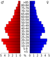
This image shows the age pyramid for Walworth County from the 2000 Census.

See also
 In Spanish: Condado de Walworth (Wisconsin) para niños
