
Arecibo, Puerto Rico facts for kids
Quick facts for kids
Arecibo
Municipio Autónomo de Arecibo
|
|||
|---|---|---|---|
|
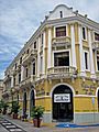
From top, left to right: Town square and cathedral, Old Tanamá Masonic Lodge, Oliver Building, and city hall in Arecibo Pueblo; Arecibo Observatory
|
|||
|
|||
| Nicknames:
"La Villa del Capitán Correa", "Muy Leal", "Ciudad del Cetí", "Diamante del Norte" (Diamond of the North)
|
|||
| Anthem: "Arecibo" | |||

Map of Puerto Rico highlighting Arecibo Municipality
|
|||
| Sovereign state | |||
| Commonwealth | |||
| First settled | 1556 | ||
| Founded | May 1, 1616 | ||
| Named for | Arasibo | ||
| Barrios | |||
| Area | |||
| • Municipality | 171.22 sq mi (443.5 km2) | ||
| • Land | 125.99 sq mi (326.3 km2) | ||
| • Water | 45.23 sq mi (117.1 km2) | ||
| Elevation | 23 ft (7 m) | ||
| Population
(2020)
|
|||
| • Municipality | 87,754 | ||
| • Rank | 7th in Puerto Rico | ||
| • Density | 512.522/sq mi (197.886/km2) | ||
| • Metro | 182,705 (MSA) | ||
| • Racial groups (2010 Census) |
85.5% White 5.1% Black 0.5% American Indian 0.2% Asian 8.6% mixed or other |
||
| Demonym(s) | Arecibeños | ||
| Time zone | UTC−4 (AST) | ||
| ZIP Codes |
00612, 00613, 00614, 00616, 00652, 00688
|
||
| Area code(s) | 787/939 | ||
| Major routes | |||


Arecibo (pronounced ah-reh-SEE-boh) is a city and municipality on the northern coast of Puerto Rico. It sits right by the Atlantic Ocean. Arecibo is located west of San Juan, the capital city. It is the largest municipality in Puerto Rico by land area.
Arecibo is divided into 18 areas called barrios and a downtown area called Arecibo Pueblo. In 2020, about 87,754 people lived there. The famous Arecibo Observatory, which once had the world's largest radio telescope, is located here. Sadly, the Arecibo telescope collapsed on December 1, 2020.
Contents
Arecibo's Name and Nicknames
The name Arecibo comes from a Taíno chief named Xamaica Arasibo. He was the leader of a settlement called Abacoa. The Spanish built their town of Arecibo in this very spot in 1556.
The word Arasibo might come from Taíno words. Ara could mean "people," and siba likely means "rock" or "stone." A river that flows through the area into the Atlantic Ocean is also named after Arecibo.
Arecibo has several cool nicknames:
- Villa del Capitán Correa (Villa of Captain Correa): This name honors Captain Antonio de los Reyes Correa. He was a Spanish soldier who bravely defended the city from a British attack.
- La Muy Leal (The Very Loyal One): This title was often given to important Spanish colonial cities.
- Diamante del Norte (Diamond of the North): This nickname comes from the city's important location on the northern coast of the island.
A Glimpse into Arecibo's Past
When the Spanish first arrived, they found the area was home to the native Taíno. Their chief was Xamaica Arasibo, who led the town of Abacoa. Spanish settlers founded Arecibo in 1556. It was the fourth Spanish settlement on the island.
Arecibo officially became a town on May 1, 1616. This happened under the rule of Captain Felipe de Beaumont y Navarra. The King of Spain gave the land to Lope Conchillos.
Other European countries sometimes tried to take over the island. On August 5, 1702, Captain Antonio de los Reyes Correa and 30 soldiers successfully defended Arecibo. They stopped an attack by two British warships. This brave defense earned the city its nickname, "The Village of Captain Correa."
In 1778, Arecibo was given the status of "Villa" by the king. It officially became a villa in 1802. In 1850, it received the title "Muy Leal" (very loyal). Over time, many parts of Arecibo became separate municipalities. These include Manati, Barceloneta, and Hatillo. In 1982, Arecibo was made a city.
On September 20, 2017, Hurricane Maria caused a lot of damage. It led to widespread flooding and damaged buildings. Many people lost their homes.
Arecibo's Geography
Arecibo is located in the Northern Coastal Plain of Puerto Rico. It also stretches into the Northern Karst region. The city is on the Atlantic Ocean. It is north of Utuado and east of Hatillo. Arecibo covers an area of about 127 square miles (330 km2).
The Rio Grande de Arecibo is the main river in the area. It flows through the middle of the municipality. South of the city, this river forms the Dos Bocas Lake. This lake is a major source of water for northern Puerto Rico.
Arecibo has two forest reserves. Cambalache State Forest is near the border with Barceloneta. Rio Abajo State Forest is between Arecibo and Utuado. Famous caves include Cueva Ventana, which offers great views. Another is Cueva del Indio, known for ancient drawings by indigenous peoples.
Arecibo's Barrios

Like all municipalities in Puerto Rico, Arecibo is divided into areas called barrios. The main city buildings, central square, and large Catholic church are in a small barrio called "el pueblo". This area is near the center of the municipality.
- Arecibo barrio-pueblo including Jareales subbarrio
- Arenalejos
- Arrozal
- Cambalache
- Carreras
- Domingo Ruíz
- Dominguito
- Esperanza
- Factor
- Garrochales
- Hato Abajo
- Hato Arriba
- Hato Viejo
- Islote
- Miraflores
- Río Arriba
- Sabana Hoyos
- Santana
- Tanamá
Arecibo's Climate
Arecibo has a tropical monsoon climate. This means it has warm temperatures all year round. It also experiences a lot of rain, especially during certain months.
| Climate data for Arecibo Observatory (elevation: 1,060 feet (320 m)) (1991–2020 normals, extremes 1980–present) | |||||||||||||
|---|---|---|---|---|---|---|---|---|---|---|---|---|---|
| Month | Jan | Feb | Mar | Apr | May | Jun | Jul | Aug | Sep | Oct | Nov | Dec | Year |
| Record high °F (°C) | 93 (34) |
94 (34) |
94 (34) |
93 (34) |
94 (34) |
97 (36) |
97 (36) |
95 (35) |
95 (35) |
96 (36) |
93 (34) |
92 (33) |
97 (36) |
| Mean maximum °F (°C) | 86.3 (30.2) |
87.1 (30.6) |
88.5 (31.4) |
89.7 (32.1) |
90.7 (32.6) |
91.6 (33.1) |
91.7 (33.2) |
91.5 (33.1) |
91.8 (33.2) |
90.7 (32.6) |
88.4 (31.3) |
86.3 (30.2) |
93.7 (34.3) |
| Mean daily maximum °F (°C) | 79.9 (26.6) |
80.7 (27.1) |
81.9 (27.7) |
83.2 (28.4) |
84.7 (29.3) |
86.7 (30.4) |
86.6 (30.3) |
86.4 (30.2) |
86.3 (30.2) |
85.5 (29.7) |
82.4 (28.0) |
80.7 (27.1) |
83.8 (28.8) |
| Daily mean °F (°C) | 70.4 (21.3) |
70.6 (21.4) |
71.3 (21.8) |
72.8 (22.7) |
74.6 (23.7) |
76.3 (24.6) |
76.4 (24.7) |
76.7 (24.8) |
76.5 (24.7) |
75.8 (24.3) |
73.6 (23.1) |
71.6 (22.0) |
73.9 (23.3) |
| Mean daily minimum °F (°C) | 61.0 (16.1) |
60.6 (15.9) |
60.6 (15.9) |
62.4 (16.9) |
64.5 (18.1) |
65.9 (18.8) |
66.3 (19.1) |
66.9 (19.4) |
66.7 (19.3) |
66.1 (18.9) |
64.7 (18.2) |
62.6 (17.0) |
64.0 (17.8) |
| Mean minimum °F (°C) | 55.8 (13.2) |
57.1 (13.9) |
57.1 (13.9) |
58.7 (14.8) |
61.4 (16.3) |
63.6 (17.6) |
63.6 (17.6) |
63.2 (17.3) |
64.1 (17.8) |
63.5 (17.5) |
60.9 (16.1) |
58.1 (14.5) |
53.2 (11.8) |
| Record low °F (°C) | 45 (7) |
48 (9) |
47 (8) |
47 (8) |
51 (11) |
54 (12) |
52 (11) |
50 (10) |
53 (12) |
50 (10) |
54 (12) |
47 (8) |
45 (7) |
| Average precipitation inches (mm) | 4.33 (110) |
3.45 (88) |
5.28 (134) |
7.43 (189) |
10.40 (264) |
6.71 (170) |
6.87 (174) |
9.53 (242) |
9.91 (252) |
8.29 (211) |
7.55 (192) |
4.83 (123) |
84.58 (2,148) |
| Average precipitation days (≥ 0.01 in) | 12.3 | 10.2 | 11.7 | 13.5 | 16.1 | 12.7 | 15.0 | 15.7 | 16.7 | 17.0 | 16.3 | 13.6 | 170.8 |
| Source: NOAA | |||||||||||||
| Climate data for Dos Bocas, Puerto Rico (200 feet (61 m)) (1991–2020 normals, extremes 1937–present) | |||||||||||||
|---|---|---|---|---|---|---|---|---|---|---|---|---|---|
| Month | Jan | Feb | Mar | Apr | May | Jun | Jul | Aug | Sep | Oct | Nov | Dec | Year |
| Record high °F (°C) | 96 (36) |
94 (34) |
96 (36) |
98 (37) |
98 (37) |
99 (37) |
98 (37) |
100 (38) |
100 (38) |
98 (37) |
97 (36) |
96 (36) |
100 (38) |
| Mean maximum °F (°C) | 88.0 (31.1) |
89.0 (31.7) |
90.4 (32.4) |
91.6 (33.1) |
93.2 (34.0) |
94.7 (34.8) |
94.2 (34.6) |
94.5 (34.7) |
93.9 (34.4) |
92.9 (33.8) |
90.1 (32.3) |
88.6 (31.4) |
95.7 (35.4) |
| Mean daily maximum °F (°C) | 84.9 (29.4) |
85.6 (29.8) |
86.3 (30.2) |
87.5 (30.8) |
88.6 (31.4) |
90.8 (32.7) |
90.9 (32.7) |
90.7 (32.6) |
90.6 (32.6) |
89.9 (32.2) |
87.3 (30.7) |
85.5 (29.7) |
88.2 (31.2) |
| Daily mean °F (°C) | 74.7 (23.7) |
74.7 (23.7) |
75.3 (24.1) |
77.0 (25.0) |
78.7 (25.9) |
80.4 (26.9) |
80.8 (27.1) |
81.0 (27.2) |
80.5 (26.9) |
79.9 (26.6) |
78.0 (25.6) |
75.9 (24.4) |
78.1 (25.6) |
| Mean daily minimum °F (°C) | 64.5 (18.1) |
63.8 (17.7) |
64.2 (17.9) |
66.5 (19.2) |
68.7 (20.4) |
70.0 (21.1) |
70.8 (21.6) |
71.2 (21.8) |
70.4 (21.3) |
69.8 (21.0) |
68.6 (20.3) |
66.2 (19.0) |
67.9 (19.9) |
| Mean minimum °F (°C) | 60.3 (15.7) |
60.0 (15.6) |
60.4 (15.8) |
62.5 (16.9) |
64.6 (18.1) |
67.1 (19.5) |
67.8 (19.9) |
68.4 (20.2) |
67.7 (19.8) |
67.0 (19.4) |
65.0 (18.3) |
62.1 (16.7) |
58.1 (14.5) |
| Record low °F (°C) | 50 (10) |
51 (11) |
51 (11) |
52 (11) |
52 (11) |
59 (15) |
58 (14) |
60 (16) |
59 (15) |
58 (14) |
58 (14) |
50 (10) |
50 (10) |
| Average precipitation inches (mm) | 3.61 (92) |
3.46 (88) |
4.82 (122) |
6.82 (173) |
10.23 (260) |
5.81 (148) |
5.36 (136) |
8.12 (206) |
9.69 (246) |
8.45 (215) |
7.34 (186) |
4.54 (115) |
78.25 (1,988) |
| Average precipitation days (≥ 0.01 in) | 14.1 | 11.6 | 12.8 | 14.2 | 17.4 | 13.1 | 15.3 | 17.3 | 17.7 | 16.9 | 17.0 | 14.5 | 181.9 |
| Source: NOAA | |||||||||||||
Fun Things to See and Do in Arecibo
Arecibo is one of Puerto Rico's oldest colonial towns, founded in 1616. It has many interesting historic buildings and places to visit.
Historic Buildings

- Cathedral of Saint Philip the Apostle: This beautiful church started being built in the late 1700s. The first church was destroyed by an earthquake in 1787. Construction on the current one began soon after. It was finished in 1846, but another earthquake damaged it just four days later! Repairs took many years. It is the second-largest church in Puerto Rico.

- Arecibo City Hall: Built in 1866, this building once held revolutionaries in 1868. An earthquake in 1918 destroyed the front part. When it was repaired, a tower and clock were added. In 1978, the building was restored to look like its original design.
- Punta Los Morrillos Lighthouse: The Spanish built this lighthouse in 1898. It became automated in 1964 and is still used today. A small park, Arecibo Lighthouse and Historical Park, is now around it.
- Arecibo Observatory: This was home to the Arecibo telescope. It was once the largest single-dish radio telescope ever built. It was also one of the world's most powerful radar-radio telescopes. The observatory was used for scientific studies. It even appeared in Hollywood movies like GoldenEye and Contact. In 1974, the telescope sent the Arecibo message into space. The telescope collapsed in 2020.
- Casa Ulanga: This building was originally a home. Over the years, it has been a bank, a store, and even a hospital. Today, it is the Arecibo Cultural Center.
Natural Wonders and Parks

- Cueva del Indio: This is an important archeological site. You can find ancient drawings made by the Taíno here.
- "Birth of the New World" Statue: This huge statue shows Christopher Columbus. It is located in Islote, Arecibo. At 295 feet (90 meters) tall, it is the tallest statue in the Americas. It was created by Russian sculptor Zurab Tsereteli.
- The Cambalache Forest Reserve: A great place to explore nature.
- Dos Bocas Lake: This is a reservoir located between Arecibo and Utuado.
- Paseo Victor Rojas: Also known as Paseo de Damas, this walk was built in 1881. It is where the old Fort San Miguel once stood.
Other Places of Interest
- Manuel "Petaca" Iguina Coliseum: This is the home of the Arecibo Captains basketball team.

- Museum of Art and History of Arecibo: Here you can see art from local artists. It also shows the city's history.
- Arecibo Beaches: Some popular beaches include Los Morillos, Los Negritos, Poza del Obispo, and Las Tunas. Be careful at Pozo del Obispo Beach, as it is considered dangerous.
Arecibo's Culture
Festivals and Events
Arecibo has celebrated its patron saint festival since 1616. The Fiestas Patronales de San Felipe Apostol takes place in May. It is a religious and cultural event. You can usually find parades, games, local crafts, and live entertainment.
Other fun festivals and events in Arecibo include:
- Bicycle competition – January
- Festival de Paracaidismo (Parachuting festival) – February
- Arecibo Carnival – February
- Folklore Festival – July
- Beach festival – July
- Artisan Fair – September
- Cetí Festival – November
- Centennial of the Puerto Rican flag – December
Sports
Arecibo has two professional sports teams. The Lobos de Arecibo play in the Roberto Clemente Professional Baseball League. The Capitanes de Arecibo play in the National Superior Basketball League.
Baseball
The Lobos de Arecibo won the national baseball championship in 1983. They also won the Caribbean World Series that same year. They won another championship in 1996.
Basketball
The Capitanes de Arecibo won their first national basketball championship in 1959. After many years, they started winning again in the 2000s. They won championships in 2005, 2008, and 2010.
Radio Stations
- WCMN-FM – Hot 102 107.3 FM
- WCMN-AM – NotiUno 1280 AM
- WNIK-FM – Super K 106 FM
- WNIK-AM – Radio Unica
- WMIA-AM – MIA Radio Arecibo 1070 AM
Arecibo's Economy
.jpg)
Arecibo has a varied economy. It includes pharmaceuticals, agriculture, and fishing. Vaqueria Ceiba Del Mar is a large dairy farm located in Arecibo.
Businesses
The main shopping mall in Arecibo is Plaza del Atlantico. There is also Plaza del Norte in the nearby town of Hatillo. In 2021, a Hilton hotel was being built in Arecibo.
Industries
Many large companies have operations in Arecibo. These include Merck and General Electric. Other important companies are Thermo King Corporation, Eaton, and ABB.
Arecibo's Population
| Historical population | |||
|---|---|---|---|
| Census | Pop. | %± | |
| 1900 | 36,910 | — | |
| 1910 | 42,429 | 15.0% | |
| 1920 | 46,578 | 9.8% | |
| 1930 | 56,525 | 21.4% | |
| 1940 | 69,192 | 22.4% | |
| 1950 | 75,361 | 8.9% | |
| 1960 | 69,879 | −7.3% | |
| 1970 | 73,468 | 5.1% | |
| 1980 | 86,766 | 18.1% | |
| 1990 | 93,385 | 7.6% | |
| 2000 | 100,131 | 7.2% | |
| 2010 | 96,440 | −3.7% | |
| 2020 | 87,754 | −9.0% | |
| U.S. Decennial Census 1899 (shown as 1900) 1910–1930 1930–1950 1960–2000 2010 2020 |
|||
According to the 2010 Census, almost all of Arecibo's population is Hispanic. Most people identify as white (of European background). There are also people of Black, American Indian, and Asian descent. Many people have mixed backgrounds.
Puerto Rico became a territory of the United States after the Spanish–American War in 1898. In 1899, the first census of Puerto Rico found that Arecibo had a population of 36,910 people.
Arecibo's Symbols
The municipality of Arecibo has an official flag and a coat of arms. These symbols were adopted in 1968.
The Flag
The flag of Arecibo uses colors and designs from the city's coat of arms. It is split into two equal parts. The left side is blue and has a belt. This belt represents "Captain Correa," a local military hero. The right side has blue and yellow diamond shapes. These refer to the coat of arms of Felipe de Beaumont y Navarra, who founded the city.
The crown on the flag represents the Taíno Chief Arasibo. The turtles represent the city's long history. They also show the native people of the region. Hunting turtles was once a source of wealth. The towers on the flag show the size of the settlement. Three towers mean it's a municipality.
The Coat of Arms

The shield of the coat of arms has gold and blue diamond shapes. It also has a blue stripe at the top. On this stripe is an open five-point crown. It is decorated with drawings inspired by Taíno art.
The people of Arecibo also honored Captain Antonio de los Reyes Correa on their coat of arms. They included a gold belt with the words "Muy Leal," meaning "Very Faithful." This represents Captain Correa's loyalty. These symbols together represent the Taíno Chief Arasibo, the governor who founded the town, and Captain Correa who defended it.
Getting Around Arecibo

Arecibo has a small airport called Antonio (Nery) Juarbe Pol Airport. It does not currently have commercial flights.
Major roads like PR-22 (Interstate PR-2) pass through the city. You can reach downtown Arecibo using PR-2, PR-10, and PR-129. There are 51 bridges in Arecibo.
The Puente Victor Rojas (Victor Rojas Bridge) collapsed during Hurricane Georges in 1998. It was rebuilt. This important bridge leads into downtown Arecibo. It was closed again in 2017 due to sea damage but reopened in 2021 after repairs.
Learning in Arecibo
_-_photograph_-_page_147.jpg)
The first school in Arecibo opened on October 12, 1805.
Today, Arecibo has many public and private schools. Public education is managed by the State Department of Education. There are also several colleges and universities in the city, including:
- University of Puerto Rico at Arecibo
- Interamerican University of Puerto Rico
- Pontifical Catholic University of Puerto Rico
- National University College
Arecibo also has other technical schools like ICPR Junior College.
Famous People from Arecibo
Many notable people come from Arecibo, such as:
- Antonio de los Reyes Correa – a military hero
- Arasibo – a Taíno Chief
- Cayetano Coll y Cuchí – the first President of the Puerto Rico House of Representatives
- Cayetano Coll y Toste – a historian
- Luisa Capetillo – a union leader and civil rights activist
- Manuel Zeno Gandía – an author
- Myrta Silva – a singer
- René Marqués – a playwright
- Iann Dior – a rapper and singer
Images for kids
-
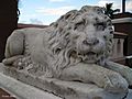
Lion in Plaza Colón
-
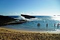
Playa La Poza del Obispo in Arecibo
-
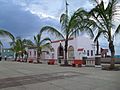
Buildings in Plaza Colon in Arecibo downtown (pueblo)
-
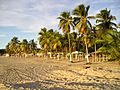
A beach in Arecibo
-

Cow from Vaquería Ceiba Del Mar in Arecibo
-

Punta los Morrillos lighthouse
-
Edificio Oliver

.jpg)


.jpg)


See also
 In Spanish: Arecibo para niños
