Atascadero, California facts for kids
Quick facts for kids
Atascadero, California
|
||
|---|---|---|
| City of Atascadero | ||
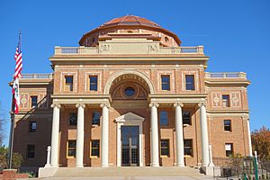
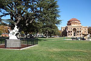
Atascadero City Hall (Atascadero Colony Administration Building), built 1914–1918
|
||
|
||
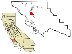
Location of Atascadero in San Luis Obispo County, California
|
||
| Country | United States | |
| State | California | |
| County | San Luis Obispo | |
| Incorporated | July 2, 1979 | |
| Founded by | Edward Gardner Lewis | |
| Named for | Bog | |
| Government | ||
| • Type | Council–manager | |
| • Body | Atascadero City Council | |
| Area | ||
| • Total | 26.13 sq mi (67.69 km2) | |
| • Land | 26.07 sq mi (67.52 km2) | |
| • Water | 0.06 sq mi (0.16 km2) 1.87% | |
| Elevation | 879 ft (268 m) | |
| Population
(2020)
|
||
| • Total | 29,773 | |
| • Density | 1,142.04/sq mi (440.95/km2) | |
| Time zone | UTC-8 (Pacific) | |
| • Summer (DST) | UTC-7 (PDT) | |
| ZIP codes |
93422–93423
|
|
| Area code | 805 | |
| FIPS code | 06-03064 | |
| GNIS feature IDs | 1660277, 2409745 | |
Atascadero is a city in San Luis Obispo County, California. Its name comes from a Spanish word that means "bog" or "mire." This refers to a muddy, soft ground area.
The city is located on U.S. Route 101. Atascadero is more inland than other cities nearby. This means it usually has warmer, drier summers and cooler winters. Other cities like San Luis Obispo and Pismo Beach are closer to the coast.
U.S. 101 is the main highway through Atascadero. Other state roads, Route 41 and Route 46, connect the city to the Pacific Coast and California's Central Valley.
E. G. Lewis founded Atascadero in 1913. As of 2020, about 29,773 people live there.
Contents
What is the History of Atascadero?
The name Atascadero comes from a Spanish word meaning "to become stuck." However, in the local Obispeño language, the area was called tsɨskikiye. This means "place of much water."
Early Inhabitants and Missions
The Chumash and Salinan Native American tribes lived in this area first. Between 1769 and 1823, Spanish Franciscans built 21 missions along the California coast. Nearby missions included Mission San Miguel Arcángel and Mission San Luis Obispo de Tolosa.
In 1821, Mexico became independent from Spain. California then became a Mexican province. The Mexican government later took over the mission lands. In 1842, Trifon Garcia received Rancho Atascadero. Pedro Estrada received Rancho Asuncion in 1845.
Founding a Planned Community
Edward Gardner Lewis, a magazine publisher, founded Atascadero in 1913. He wanted to create a planned community, almost like a perfect town. He had done something similar before in Missouri.
Lewis bought the Atascadero Ranch in 1912. He gathered investors and celebrated the purchase on July 4, 1913. Early settlers lived in a "tent city" while the town was being built. Lewis hired experts to plan the city and its farms for about 30,000 future residents.
In 1914, the land was mapped out and divided. Thousands of acres of fruit orchards were planted. A water system was also put in place. An 18-mile (29 km) road was built through the Santa Lucia Mountains to the ocean at Morro Bay. Lewis also built cottages and a hotel there.
Important Buildings and Landmarks
The first big public building in Atascadero was the Atascadero Press Building. It had special printing presses, the first of their kind west of Chicago. Lewis used it to publish the Atascadero News newspaper and a photo magazine.
The most important building in Lewis's plan was the Rotunda Building. It was designed in an Italian Renaissance style. This building served as the Atascadero City Hall and Museum for many years. It was damaged in the 2003 earthquake. After a lot of repair work, it reopened in August 2013. This unique building, built between 1914 and 1918, is now a California Historical Landmark.
The Rotunda Building was finished in 1918. It was the main office for the Atascadero Colony. It has also been a private school, a veterans' building, and county offices. The city hall has a 40-foot (12 m) dome on top.
Another important early building is the Carlton Hotel. It was built in 1929. It is located near the Sunken Gardens. The hotel was empty for many years but was fully restored and reopened in 2003.
The Skytherm House
Atascadero is also known for the Skytherm house. This house was a pioneer in using solar power for heating and cooling. It used water-filled bags on the roof with movable covers. During the day, the covers could be opened to let the sun warm the water for heating at night. For cooling, the covers would be closed during the day to keep the house cool. At night, the covers would open to let the water cool down.
What is Atascadero's Geography and Climate?
Atascadero covers about 26.1 square miles (67.6 km²). Most of this area is land. It is the largest city in San Luis Obispo County by land area. The city is also near the Carrizo Plain.
Climate in Atascadero
Atascadero has a hot-summer Mediterranean climate. This means it has hot, dry summers and mild, wet winters. The temperature can change a lot between day and night.
| Climate data for Atascadero | |||||||||||||
|---|---|---|---|---|---|---|---|---|---|---|---|---|---|
| Month | Jan | Feb | Mar | Apr | May | Jun | Jul | Aug | Sep | Oct | Nov | Dec | Year |
| Mean daily maximum °F (°C) | 61 (16) |
65 (18) |
67 (19) |
73 (23) |
80 (27) |
87 (31) |
91 (33) |
92 (33) |
88 (31) |
81 (27) |
68 (20) |
62 (17) |
76 (25) |
| Mean daily minimum °F (°C) | 33 (1) |
37 (3) |
39 (4) |
40 (4) |
45 (7) |
49 (9) |
52 (11) |
52 (11) |
48 (9) |
42 (6) |
39 (4) |
31 (−1) |
42 (6) |
| Average precipitation inches (mm) | 6.9 (180) |
6.4 (160) |
5.4 (140) |
1.8 (46) |
0.6 (15) |
0.1 (2.5) |
0 (0) |
0.1 (2.5) |
0.3 (7.6) |
1.7 (43) |
3.0 (76) |
5.0 (130) |
31.3 (802.6) |
How Many People Live in Atascadero?
| Historical population | |||
|---|---|---|---|
| Census | Pop. | %± | |
| 1950 | 3,443 | — | |
| 1960 | 5,983 | 73.8% | |
| 1970 | 10,293 | 72.0% | |
| 1980 | 16,232 | 57.7% | |
| 1990 | 23,138 | 42.5% | |
| 2000 | 26,411 | 14.1% | |
| 2010 | 28,310 | 7.2% | |
| 2020 | 29,773 | 5.2% | |
| U.S. Decennial Census | |||
As of the 2020 Census, Atascadero had a population of 29,773 people.
Population Details
In 2010, there were 28,310 people living in Atascadero. Most residents (86.4%) were White. About 15.6% of the population identified as Hispanic or Latino.
There were 10,737 households in the city. About 31.9% of these households had children under 18. The average household had about 2.51 people. The average age of people in Atascadero was 41.0 years.
How Do People Get Around Atascadero?
Atascadero is located where U.S. 101 and State Route 41 meet. It is about halfway between Los Angeles and San Francisco on U.S. 101.
Main Roads
 U.S. Route 101 (US 101) is the busiest road in Atascadero. It runs north-south through the city. Northward, it goes to San Jose and San Francisco. Southward, it goes to San Luis Obispo, Santa Barbara, and Los Angeles.
 State Route 41 (SR 41) runs northeast-southwest through the city. Going southwest, it leads to the Pacific Ocean in Morro Bay. Going northeast, it connects to Interstate 5 and continues towards Fresno.
Train Travel
The Union Pacific Railroad's Coast Line runs through Atascadero. This line carries Amtrak's Coast Starlight passenger train.
The Atascadero Transit Center helps people connect to nearby train stations. You can take a bus from there to the Paso Robles station or San Luis Obispo station. Amtrak Thruway buses also connect Atascadero to other cities like Visalia and Santa Maria.
Airports
The closest airport is San Luis Obispo County Regional Airport (SBP). It is located south of San Luis Obispo. This airport is used for general flights and has commercial airlines. It serves areas from southern Monterey County to northern Santa Barbara County.
What Schools Are in Atascadero?
The Atascadero Unified School District has several schools. This includes elementary schools, middle schools, high schools, and a college.
Elementary Schools
- Monterey Road Elementary (Kindergarten-5th grade)
- San Benito Road Elementary (Kindergarten-5th grade)
- Santa Rosa Road Elementary (Kindergarten-5th grade)
- San Gabriel Road Elementary (Preschool-5th grade)
- Atascadero Fine Arts Academy (4th-8th grade)
- North County Christian School (Kindergarten-6th grade) (Not part of Atascadero Unified)
- Santa Margarita Elementary (Kindergarten-6th grade) (In Atascadero Unified, but outside city)
- Creston Elementary (Kindergarten-6th grade) (In Atascadero Unified, but outside city)
- Carissa Plains Elementary (Kindergarten-6th grade) (In Atascadero Unified, but outside city)
Middle Schools
- Atascadero Middle School (6th-8th grade)
- Atascadero Fine Arts Academy (4th-8th grade)
- North County Christian School (7th-8th grade)
High Schools
- Atascadero High School (9th-12th grade)
- Paloma Creek High School (9th-12th grade)
- North County Christian School (9th-12th grade)
Colleges
- San Joaquin Valley College (SJVC) - Atascadero Campus
Sports and Recreation
Atascadero has the Colony Park Community Recreational Center.
Lake Nacimiento is a large lake about 18 miles (29 km) northwest of the city. It's in the Santa Lucia Range. At the lake, you can go fishing, swimming, waterskiing, wakeboarding, and jetskiing.
Parks in Atascadero
Atascadero has many parks for fun and relaxation:
- Apple Valley Park
- Colony Park
- Atascadero Lake Park
- Joy Park (a special park for everyone, with a fence)
- Paloma Creek Park
- A-town Park (has ramps for scooters and skateboards)
- Stadium Park
- Sunken Gardens
- Heilmann Regional Park
- Chalk Mt. Park and Golf Course
- Dove Creek Park
- "Little" Park
City Facilities
Atascadero City Hall
The Atascadero City Hall, also called the Rotunda, was built in 1918. It was part of founder E.G. Lewis's plan for a perfect community. In 2003, the building was damaged by the 6.6 San Simeon earthquake. The city used a bowling alley as a temporary city hall while the building was repaired. In August 2013, after ten years, the original city hall reopened and is still in use today.
Atascadero Fire Department
The Atascadero City Fire Department helps with all kinds of emergencies. They respond to medical calls, fires, car crashes, and other situations. The fire department has two stations.
Colony Park Community Center
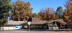
This community center is 18,000 square feet (1,672 m²). It has a full-size gym, a teen center, a café, an arts and crafts room, a dance room, and meeting rooms.
Paramedic and Ambulance Services
San Luis Ambulance and the Atascadero Fire Department provide paramedic and ambulance services.
Images for kids
See also
 In Spanish: Atascadero para niños
 | Jewel Prestage |
 | Ella Baker |
 | Fannie Lou Hamer |


