
Aztalan State Park facts for kids
|
Aztalan
|
|

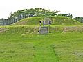
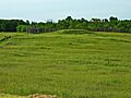
Steps on the eastern face of the largest platform mound, Aztalan State Park
|
|

Location in Wisconsin

Location in the United States
|
|
| Location | Near Lake Mills on WI 89, Jefferson County, Wisconsin, USA |
|---|---|
| Nearest city | Lake Mills, Wisconsin |
| NRHP reference No. | 66000022 |
Quick facts for kids Significant dates |
|
| Added to NRHP | October 15, 1966 |
| Designated NHL | July 19, 1964 |

Aztalan State Park is a special place in Wisconsin. It's a state park located near the Crawfish River in Jefferson County. This park protects the remains of an ancient Native American settlement.
The people who lived here were part of the Mississippian culture. They built huge earth mounds and lived in a fortified village. This settlement was active between the 10th and 13th centuries. Aztalan became a National Historic Landmark in 1964. It was added to the National Register of Historic Places in 1966. Today, the park covers about 172 acres (70 hectares).
Contents
Ancient Aztalan: A Thriving Village (900–1300)

Aztalan was first settled around 900 CE. The people belonged to the Middle Mississippian Tradition. Their main city was Cahokia in Illinois, which was huge for its time. It had 20,000 to 30,000 people.
Mississippian settlements are known for several things:
- They built large earth mounds.
- They created strong stockades (wooden walls).
- They made special Mississippian culture pottery.
- They were skilled farmers.
The people of Aztalan traded with other groups far away. They used rivers to travel and move goods. For example, they got copper from Michigan and shells from the Gulf of Mexico. They also traded for special stone from other parts of the Midwest.
Sometime between 1200 and 1300 CE, the Aztalan settlement was left empty. Experts aren't sure why. It might have been due to a lack of resources or more conflicts with other groups. A colder period called the Little Ice Age also began around 1300. This could have made farming harder.
Daily Life in Aztalan
Most people lived in round or rectangular houses. These homes were built between the river and a protective wall. The village was carefully planned around a central open area. This area was likely used for ceremonies and public gatherings.
The houses were made with wooden posts for the frame. The walls were filled in with "wattle and daub." This was a mix of grass and clay. The roofs were covered with bark or thatch. Doorways usually faced south to block cold winter winds.
Inside, families slept on beds made of poles. They used tamarack branches, deer skins, and furs for comfort. A fire often burned in the middle of the house. A hole in the roof let out the smoke. Storage pits in the floor held corn, nuts, and seeds.
The location of Aztalan was great for finding food. Their main food was corn, which they grew. They also gathered acorns, hickory nuts, and berries. Tobacco was grown for special rituals.
For meat, they hunted deer a lot, especially in winter. They also caught beavers, elk, foxes, muskrats, and raccoons. Birds and turtles were also part of their diet. They caught many fish from the Crawfish River. They even built rock barriers called fish weirs to help with fishing.
The people also used natural resources for tools and building. Trees provided wood for houses, weapons, and firewood. Shells were used for jewelry, beads, spoons, and digging tools. They dug clay from the river to make pottery.


Special Features of Aztalan

The most striking features at Aztalan are its pyramid-shaped, flat-topped mounds and the stockades. These were important for ceremonies and for protecting the village.
The Mounds
There are three main platform mounds at the site.
- The largest mound is in the southwest corner of the stockade.
- Another large one is in the northwest corner.
- The smallest mound is along the east side, near the Crawfish River.
- A hill in the southeast corner is natural, not built by the people.
The largest mound was built in three stages. It had steps leading to the top. A building was constructed on its flat top. This building might have stored corn for the village. It could also have been used for ceremonies or as a home for important leaders. Each time the mound was made bigger, the building on top was rebuilt.
The northwestern mound was used for special burials. It was also built in three stages. A small building was on its west side. Inside, the bodies of ten people were laid out. Another person's bones were bundled together. After the bodies were placed, the building was burned.
The eastern mound had a large, open-walled structure on top. It had fire pits lined with white sand. The exact purpose of this mound is still a mystery.
Outside the main stockade, to the northwest, are "marker mounds." When archaeologists dug into these, they didn't find burials. Instead, each mound had a large post in its center. These posts might have marked the site for travelers. They could also have been used for announcements or to track astronomical events. Similar uses have been found at other Mississippian sites like Cahokia.
The Stockade Walls

The village was surrounded by a palisade. This was a wall of logs standing upright in the ground. Flexible willow branches were woven through the posts. Then, a mix of clay and grass was plastered over it to fill gaps. This technique is like "wattle and daub."
At one point, a smaller stockade was built inside the main one. Experts are not sure if both walls were used at the same time for double defense. Or, if one was built after the other fell apart.
In 1850, a scientist named Increase A. Lapham studied the site. He described the outer stockade as being very long. It had at least 33 square bastions. These were like small towers that allowed defenders to shoot arrows. The entrance to the village was hidden, blending in with the wall.
Over time, two sets of outer stockades were built. The first one rotted away. The second one burned down and was never rebuilt. It's not fully clear if the stockade was only to keep out enemies. It might have had other purposes too.
Aztalan's Rediscovery (1835–1919)
A young man named Timothy Johnson found the ruins of Aztalan in 1835. The first rough survey was done in 1836 by N. F. Hyer. He published his discovery in a newspaper.
The name "Aztalan" was given by Mr. Hyer. He thought it might be linked to the Aztecs of Mexico. The Aztecs had a story that their ancestors came from a northern land called Aztalan. The name "Aztalan" means "near water" in a Mexican language. This made people think the Aztecs might have come from the Great Lakes area.
Hyer wanted to protect the ruins. But in 1838, the land was sold for $22. After that, the site was plowed for farming. Mounds were flattened. Pottery pieces and "Aztalan brick" were taken away to fill potholes. Many artifacts were also taken by souvenir hunters.
In 1850, Lapham urged people to save the stockade. At that time, parts of it were still standing.
Becoming a State Park (1919–Present)

In 1919, archeological digs began at Aztalan. Dr. S. A. Barrett led these efforts. In 1920, groups like the State Historical Society of Wisconsin started working to save what was left. They bought some land in 1921.
Efforts to preserve the site continued. In 1936, groups asked the government for money to rebuild the stockade. They didn't get it then. But in 1941, a new local group, the Lake Mills-Aztalan Historical Society, pushed hard to save the area.
In 1945, the Wisconsin State Assembly began looking into making Aztalan a state park. In 1947, the Wisconsin State Legislature asked the State Conservation Commission to buy Aztalan. In 1948, 120 acres (49 hectares) were bought. Other societies also donated their land. Finally, Aztalan opened to the public in 1952 as Aztalan State Park.
Aztalan was named a National Historic Landmark in 1964. It was added to the National Register of Historic Places in 1966. In 1968, parts of the stockade wall were rebuilt. New posts were placed in the original holes. A section was also covered with the wattle and daub mix, but this has since worn away.
Images for kids
-
Steps on the eastern face of the largest platform mound, Aztalan State Park
-
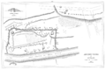
1855 map of Aztalan historical site; north is to the right.
-
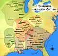
Approximate areas of Mississippian and related cultures. Aztalan is in the Oneota region of the map.
-

Largest platform mound viewed from the south and part of a stockade
-
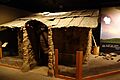
A replica of an Aztalan house at the Wisconsin Historical Museum
-
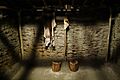
Inside the Aztalan house replica in the museum
-
Reconstructed stockade behind the northwestern mound
-
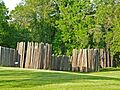
Reconstructed stockade near the Crawfish River
-
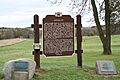
Historic marker for Aztalan State Park
