Bonneville County, Idaho facts for kids
Quick facts for kids
Bonneville County
|
||
|---|---|---|

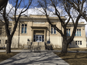
Bonneville County Courthouse
|
||
|
||

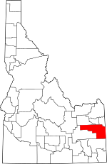
Location within the U.S. state of Idaho
|
||
 Idaho's location within the U.S. |
||
| Country | ||
| State | ||
| Founded | February 7, 1911 | |
| Named for | Benjamin Bonneville | |
| Seat | Idaho Falls | |
| Largest city | Idaho Falls | |
| Area | ||
| • Total | 1,901 sq mi (4,920 km2) | |
| • Land | 1,866 sq mi (4,830 km2) | |
| • Water | 35 sq mi (90 km2) 1.8% | |
| Population
(2020)
|
||
| • Total | 123,964 | |
| • Estimate
(2022)
|
129,496 |
|
| • Density | 63.8/sq mi (24.6/km2) | |
| Time zone | UTC−7 (Mountain) | |
| • Summer (DST) | UTC−6 (MDT) | |
| Congressional district | 2nd | |
Bonneville County is a county located in the U.S. state of Idaho. In 2020, about 123,964 people lived here. This makes it the fourth-largest county in Idaho by population. It is also the most populated county in eastern Idaho.
The main city and county seat is Idaho Falls. Bonneville County was created in 1911. It was named after Benjamin Bonneville (1796–1878). He was a French-born officer in the U.S. Army. He was also a fur trapper and explorer in the American West. Bonneville County is part of the Idaho Falls Metropolitan Statistical Area.
Contents
History
Bonneville County was officially formed on February 7, 1911. The state legislature created it from parts of Bingham County, Idaho. It was named after Captain B.L.E. Bonneville. He explored the Snake River area in the 1830s.
A small town started in 1864 near a ferry crossing on the Snake River. This town was first called Eagle Rock. Later, in 1891, its name changed to Idaho Falls.
Today, Bonneville County has different types of land. It goes from dry desert areas to green valleys with farms. It also has tall, forested mountains. The area that is now Bonneville County was first part of Oneida County. This large county covered much of southern Idaho. Later, it became the northern part of Bingham County. Finally, in 1911, Bonneville County was formed. Idaho Falls became its county seat.
Even before towns and governments were set up, this region had a rich history. Native American tribes traveled through the county. They went to places where camas plants grew for harvest. In 1808, John Colter explored the area. Major Andrew Henry saw the country in 1810. Then, in 1832, Captain B.L.E. Bonneville visited. The county was later named after him.
The first real town in the county was Keenan. It was in the far eastern part of Bonneville County. Keenan had almost 1,000 people around 1870. At the same time, Caribou City also grew. Eagle Rock, which is now Idaho Falls, also started to get more people. For a while, it seemed like Caribou City might become bigger than Eagle Rock.
A gold rush happened in the Caribou region. Even though the settlements were not permanent, it was a big event. People found about $50 million worth of gold dust and nuggets. Besides gold, raising cattle was the first major business. Before railroads came, Matt Taylor brought a herd of cattle to the valley. As more settlers arrived, they also started raising cattle. This became a successful and growing business.
Farmers discovered that many crops could grow well in the area. Farms spread across the valley. In 1888, some farmers planted small fields of potatoes. That fall, they sold them for 90 cents per hundred pounds. This started a new industry. In the early 1900s, more tests showed that sugar beets could also grow well. In 1902, Mark Austin looked into building a sugar factory. He suggested building it east of Idaho Falls. The factory's first stone was laid in 1903. That fall, the factory started making sugar. A small town called Lincoln grew up around it.
From 1863 to 1900, Bonneville County changed a lot. The Utah and Northern Railroad Company made Eagle Rock a major stop. They built repair shops there, and the town grew. By 1885, Eagle Rock had 1,500 people. But in 1887, the railroad shops moved to Pocatello. This almost made Eagle Rock a ghost town. However, with new ways to water crops, the town became lively again. It became a very important shipping point between Ogden, Utah and Butte, Montana.
Idaho Falls
On August 26, 1891, the name of Eagle Rock changed to Idaho Falls. This was because of the waterfall in the river on the west side of the city. The town officially became a city on April 6, 1900. Joseph A. Clark was its first Mayor. Idaho Falls was growing. It was headed for a future where it would become a center for atomic energy. But in 1900, it was still controlled by Blackfoot. Blackfoot was the county seat of Bingham County at that time. It took 11 more years before Idaho Falls became the county seat.
Geography
Bonneville County covers about 1,901 square miles. About 1,866 square miles is land, and 35 square miles (1.8%) is water. The Snake River flows through Bonneville County. It starts at the Wyoming border as the Palisades Reservoir. The river leaves the county near its northern border. Then it turns and re-enters about 20 miles west. From there, it flows southwest through Idaho Falls.
Adjacent counties
- Madison County - north
- Teton County - north
- Teton County, Wyoming - northeast
- Lincoln County, Wyoming - southeast
- Caribou County - south
- Bingham County - west
- Jefferson County - northwest
Major highways
National protected areas
- Caribou National Forest (part)
- Grays Lake National Wildlife Refuge (part)
- Targhee National Forest (part)
Demographics
| Historical population | |||
|---|---|---|---|
| Census | Pop. | %± | |
| 1920 | 17,501 | — | |
| 1930 | 19,664 | 12.4% | |
| 1940 | 25,697 | 30.7% | |
| 1950 | 30,210 | 17.6% | |
| 1960 | 46,906 | 55.3% | |
| 1970 | 51,250 | 9.3% | |
| 1980 | 65,980 | 28.7% | |
| 1990 | 72,207 | 9.4% | |
| 2000 | 82,522 | 14.3% | |
| 2010 | 104,234 | 26.3% | |
| 2020 | 123,964 | 18.9% | |
| 2023 (est.) | 131,366 | 26.0% | |
| U.S. Decennial Census 1790–1960, 1900–1990, 1990–2000, 2010–2020 |
|||
2010 census
In 2010, there were 104,234 people living in Bonneville County. There were 36,629 households and 26,787 families. The population density was about 55.9 people per square mile.
Communities

Cities
- Ammon
- Idaho Falls
- Iona
- Irwin
- Ririe (partially)
- Swan Valley
- Ucon
Census-designated place
Unincorporated communities
- Beachs Corner
- Bone
- Osgood
- Palisades
Ghost towns
- Herman
- Caribou City
Education
School districts in Bonneville County include:
- Bonneville Joint School District 93
- Idaho Falls School District 91
- Ririe Joint School District 252
- Shelley Joint School District 60
- Soda Springs Joint School District 150
- Swan Valley Elementary School District 92
The College of Eastern Idaho serves this county. It is the only county in its tax area.
See also
 In Spanish: Condado de Bonneville para niños
 | Percy Lavon Julian |
 | Katherine Johnson |
 | George Washington Carver |
 | Annie Easley |


