
Bradford Dale (Yorkshire) facts for kids
Quick facts for kids Bradford Dale |
|
|---|---|
| Bradfordale | |
.jpg)
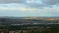
An image looking north eastwards across Bradford and Bradford Dale.
The dale extends across the middle foreground from left to right (where the warehouses are) and then changes direction to go back to the left around Manningham Mills (the very tall chimney in the middle). The steep sides of Airedale are the hillsides in the distance |
|

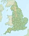
Bradford Dale
Location in England
|
|
| Floor elevation | 85 m (279 ft) |
| Length | 8 mi (13 km) East–north |
| Width | 6 mi (9.7 km) East–west |
| Geography | |
| Location | City of Bradford |
| Country | England |
| State/Province | Yorkshire and the Humber |
| River | Bradford Beck |
Bradford Dale (also called Bradfordale) is a valley in West Yorkshire, England. It's a side valley of Airedale. Water from Bradford Beck flows through it, across the City of Bradford, and into the River Aire at Shipley. Even though it's called a "dale" (which means valley), it's not part of the famous Yorkshire Dales. Instead, it's known for its history of factories and industry.
Before Bradford grew into a big city, this valley was a mix of small villages surrounded by forests. During the Industrial Revolution, machines changed how wool was made. This led to many people moving here, and the small villages became part of the growing city of Bradford. By 1897, Bradford officially became a city. Because of this growth, the name "Bradford Dale" isn't used much anymore. Sometimes, people still use it to describe the flat land between Bradford City Centre and Shipley.
The wool and textile industries greatly changed the valley and the whole region. People also found coal and special hard sandstone here. This stone, called Elland Flags and Gaisby Rock, was great for building and even for harbours because it resisted water. Unlike other valleys with big rivers, Bradford Dale only has the small Bradford Beck. This meant clean water had to be brought in from far away, like Nidderdale, for people and factories. Sadly, much of the beck in the city centre is now hidden underground and was very polluted by the old industries.
Contents
History of Bradford Dale
Bradford Dale is like a natural bowl, about 6 to 8 miles (10 to 13 km) wide. It sits on the eastern side of the Pennines hills. The only flat way out of the valley is north, towards the River Aire at Shipley. The valley where the Bradford Beck flows has had many names over time, like Bradforddale and Broadfordesdale. The city of Bradford got its name from "Broad Ford," which was a wide crossing point over the Bradford Beck. Bradford became a city in 1897.
Before the Industrial Revolution, "Bradford Dale" was the name that connected all the small communities in the valley. Places like Allerton, Bolton, and Manningham were separate villages. But after Bradford became a city, these places became its suburbs. So, people started saying they were "in Bradford" instead of "in Bradford Dale."
Ancient Times and Early Settlements
After the last Ice age, a huge lake called Lake Bradford covered the valley of the River Aire. Melted ice from places like Cottingley and Keighley fed this lake. Water also formed lakes higher up in Bradford Dale. When the water went away, people from the Paleolithic and Mesolithic periods settled in the wooded valley. They were hunter-gatherers.
Later, the Romans arrived, and then the Anglo-Saxons. This pushed the Celts to the edges of the valley. But it also brought Christianity to the area. The Church of St Peter, built in what is now Bradford city centre, was sometimes called "St Peters in Bradfordale." It became a cathedral much later, in 1919.
Medieval and Civil War Times
In the 13th century, the valley was called vallis dé Bradford. By the 14th century, there were cloth-making businesses here. However, the Black Death plague killed many people, and other plagues and raids by Scots caused many to leave.
During the English Civil War in 1642, wool bales were hung from the church to protect it from cannons. Bradford supported the Parliamentarian side, and some say this led to "impeded trade" for 50 years. This allowed nearby Leeds to grow more. By the end of the 17th century, wool farming became popular. People farmed in summer and processed wool in winter.
The Rise of Industry
By the late 18th century, Bradford town had fewer than 3,000 people and was mostly about farming and traditional wool work. Early 19th-century maps show Bradford as a small market town with open streams. Most of the town was on the north side of Bradford Beck.
By the mid-19th century, the population had grown to 4,000. In the late 19th and early 20th centuries, the lower parts of the valley became very busy. Coal mining, quarrying, canals, roads, and railways changed the landscape. Many forests were cut down. The wool trade grew, and by 1861, Bradford's population was over 100,000, making it the ninth largest town in England.
The area around Manningham was still beautiful in the 1860s. But when a railway station opened there in 1868, industry and people moved in quickly. Manningham's population jumped from 20,000 in 1871 to 37,000 in 1881. The Borough of Bradford was created in 1847, with the motto Labor Omnia Vincit (Work Conquers All). This motto stayed when Bradford became a city in 1897.
Transport and Water in the Valley

The City of Bradford sits in a natural bowl, surrounded by hills up to 1,200 feet (370 m) high. Many streams flow into the city, like Pitty Beck and Horton Beck. They all join in the city centre to form Bradford Beck, which then flows north. These streams and the valley's geology created Bradford Dale. The area that collects water for the dale is over 62 square kilometres (24 sq mi).
Bradford Dale is said to start above the moors at Thornton. It then heads east and curves north towards Shipley, following the Bradford Beck. Shipley is where the Bradford Beck meets the River Aire. This low, flat land between Shipley and Bradford was perfect for building the Bradford Canal and the first railway lines.
Water Supply Challenges
Unlike other big cities, Bradford didn't have a major river nearby. But the wool industry needed lots of clean water to wash wool. People also needed clean drinking water. In 1848, Bradford had 38 mills and 88 steam engines, all needing water. As early as 1790, companies started bringing fresh water into Bradford from outside the valley.
The Bradford Beck and the Bradford Canal became very polluted. At one point, the canal was so polluted that gases bubbling up from its surface could be set on fire! Because of this, the Bradford Corporation (the city's government) bought the Bradford Water Company. They built the Nidd Aqueduct to bring clean water into the valley from Nidderdale, far away. Other reservoirs on the moors also supply water. A sewage plant was built at Frizinghall, but it wasn't big enough for all the factory waste. So, a new plant was built at Esholt in Airedale.
Air Pollution
As factories grew, so did air pollution. By 1847, a rule said that all chimneys had to be at least 90 feet (27 m) tall to help smoke escape the valley. But even then, these chimneys "belched out large quantities of smoke, ash, sulphur and other irritants." In still air, especially in winter, polluted air would get trapped in the valley, causing deadly "pea-soup fogs."
Roads and Railways
Today, many roads cross Bradford Dale. The A647 and B6145 run on either side of the small valley in the west. From the city centre, the A6037 and A650 go north through the valley to Shipley.
The railways that went up the western edge of the dale, like the Queensbury Lines, were known as the "Alpine Lines" because they were so steep and hilly. Bradford has two main train stations, Forster Square and Bradford Interchange. They are at different heights, which has made it hard to connect them with a single through line. This has sometimes made it difficult for businesses and people to travel easily. There are plans to build a central station if a new high-speed rail line, HS3, is built.
Geology of the Valley

Bradford Dale is mostly made of coal layers, with hard sandstone in some places. While the famous hard millstone grit is more common further up the Aire Valley, Bradford Dale had good spots for sandstone flags. Quarries at Bolton Woods were known for producing the famous Elland Flags. This stone could be used for paving, building, roof tiles, and crushed stone. Elland Flags from Bolton Woods were used to build town halls in Bradford, Leeds, and Manchester. Bolton Woods Quarry closed in 2016 after 150 years.
Other quarries, like Spinkwell and Cliffe Wood, were closer to Bradford. Spinkwell was especially known for a reliable stone called Gaisby Rock (Sprinkwell Stone). This stone was used in the Leeds University Great Hall, Wakefield Town Hall, and Manchester Town Hall. Stone was even sent by train to southern England to build places like the Woolwich Arsenal and Portsmouth Admiralty Docks.
Coal Mining
Bradford Dale is on the northern edge of the South Yorkshire Coalfield. This area provided coal, fireclay, ironstone, sandstone, and brick clay. All these materials helped Bradford grow hugely in the 18th and 19th centuries. In 1866, collieries (coal mines) in the Bradford area produced 1,900,000 tonnes of coal. Most of this coal was used to melt metals.
While there was coal north of Bradford, the seams were thin and didn't produce much. The coal was also known to be of poor quality. However, some mines had names like Bolton Woods Coal Mine. The coal mines south of the city, around Low Moor, were better for producing large amounts of coal. By 1924, only three collieries were still active in the area. Some open-pit mining was restarted during the Second World War.
Coal was sent out of the valley by canal or by railway. Coal was also mined at Thornton and near the small village of Egypt. At Egypt, the coal was only 23 yards (21 m) below the surface. Egypt also had four fireclay quarries. These quarries produced so much waste that huge walls were built to hold it back. These walls were called the Walls of Jericho but were taken down in the 1980s because they were unsafe.
Industry in Bradford Dale
.jpg)
The main industries in Bradford Dale were wool and worsted (a type of wool fabric). The first record of a fulling mill (which cleans and thickens wool) near the city centre was in 1316. When Flemish weavers came to England during the time of King Edward III, it helped the wool trade in the valley. In the 18th and early 19th centuries, most textile work was done in people's homes. About 6,000 people worked in the industry across the valley.
Large wool factories started to appear in the valley from the 19th century onwards. Many wool warehouses and mills were built in the Little Germany area of Bradford. Building these was sometimes difficult because of old mine workings underneath.
Lister Mills
In 1871, the mills at Manningham burned down. In 1873, Samuel Cunliffe Lister built his new Manningham Mills (also known as Lister Mills). This factory was designed like the wool warehouses in Little Germany. It made textiles, especially silk. When it was fully working, it was the largest textile factory in England and the biggest silk factory in the world. During the Second World War, the mill made parachute cord and silk for the British military. The mills closed in 1992.
Metal and Chemical Industries
Most metalworking and chemical industries were in Low Moor, south of the valley. However, the Bierley Ironworks used most of the coal mined within the dale. This meant lime had to be brought in from places like Skipton, as Bradford Dale didn't have its own lime. In the early 19th century, Bierley, Bowling, and Low Moor Ironworks were important for making cannonballs for the British military during the Napoleonic Wars. At that time, they produced more metal than similar factories in the traditional steel-making area of South Yorkshire.
Settlements in Bradford Dale
Besides the city of Bradford itself, the following places were historically part of Bradford Dale:
- Allerton
- Bierley
- Bolling
- Bolton
- Chellow
- Clayton
- Eccleshill
- Frizinghall
- Heaton
- Great Horton and Little Horton
- Manningham
- Mountain
- Queensbury
- Scholemoor
- Thornton
- Wilsden
Shipley is also mentioned as being where the valleys of Bradford and the Aire meet.
Images for kids
-
An image looking north eastwards across Bradford and Bradford Dale.
-
Location within England
-
Bradford Beck under Broadway shopping centre
-
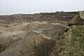
Bolton Woods Quarry
-
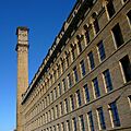
Manningham Mills
-
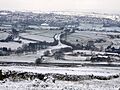
The site of Queensbury railway station. Thornton is in the distance.

.jpg)
