Cairo–Cape Town Highway facts for kids
Quick facts for kids
Trans-African Highway 4 |
||||
|---|---|---|---|---|
 |
||||
| Route information | ||||
| Length | 10,228 km (6,355 mi) | |||
| Major junctions | ||||
| North end | ||||
| South end | ||||
| Highway system | ||||
Template:Infobox road/browselinks/AFR
|
||||
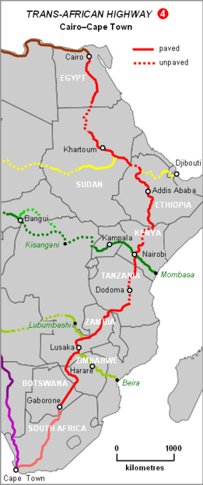
The Cairo–Cape Town Highway is a very long road in Africa. It's part of a big network of roads called the Trans-African Highway system. This system is being built by several important groups, like the United Nations Economic Commission for Africa (UNECA) and the African Union. The highway stretches for about 10,228 kilometers (6,355 miles). It connects Cairo in Egypt all the way down to Cape Town in South Africa.
Long ago, the British Empire wanted to build a road through its colonies in Africa. This idea was known as the Cape to Cairo Road or the Pan-African Highway. In some parts of Africa, people called it the Great North Road. This road was never fully finished while the British still ruled these lands.
In the 1980s, the idea for this road came back. It became part of the modern Trans-African Highway plan. The new Cairo-Cape Town Highway uses many of the same roads as the old plan. But it also takes some different paths in a few places.
Contents
A Road with a Long History
The first idea for a "North South Red Line" route came in 1874. It was suggested by Edwin Arnold, an editor for The Daily Telegraph newspaper. This newspaper helped fund an expedition by Henry Morton Stanley to explore Africa. The original plan wasn't just for a road. It included a mix of railway and river travel.
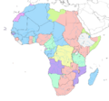
The British wanted this road to connect their colonies across Africa. These colonies included places like South Africa, Rhodesia (now Zimbabwe and Zambia), Nyasaland (now Malawi), Kenya, Sudan, and Egypt. The British believed this road would help them control Africa better. It would also link important cities like Cape Town, Johannesburg, Harare, Lusaka, Nairobi, Khartoum, and Cairo.
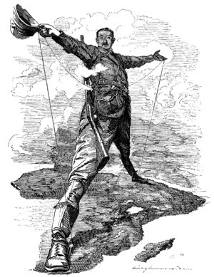
A big supporter of this idea was Cecil John Rhodes. He really wanted a railway to connect the continent. Even though German East Africa (now Tanzania) was a gap in British lands, Rhodes thought Germany would be an ally. Before he died, he convinced the German Kaiser to allow a telegraph line through his colony. After 1918, German East Africa became British, filling the gap.

One challenge was that the British Empire started to lose its power. Its colonies became independent. Egypt became independent in 1922, and Sudan in 1956. This ended the original colonial reason for the road.
France had its own plan in the late 1890s. They wanted to link their colonies from west to east across Africa. This would connect Senegal to Djibouti. But this plan failed after a disagreement with Britain in Sudan, known as the Fashoda Incident.
The first known attempt to drive a car from Cape Town to Cairo was in 1913-14. But it ended sadly when Captain Kelsey was killed by a leopard. The first successful car journey happened in 1924-1926. It was led by Major Chaplin Court Treatt. His wife, Stella Court Treatt, wrote a book about their adventure. They drove two trucks and took over a year to complete the trip.
The modern plan for the highway started in the 1980s. South Africa was not included at first because of its Apartheid laws. But now, the highway is recognized to continue into South Africa. Most people see Cape Town as the southern end of this important road.
Traveling the Highway Today
The Cairo-Cape Town Highway is a long and varied journey. Here's what it's like in different parts:
North Africa: Egypt and Sudan
The road between Dongola and Wadi Halfa in northern Sudan is now open. You can cross the border between Egypt and Sudan at the Qastal-Ashkeet post.
Between Wad Madani in Sudan and Wereta in Ethiopia, the highway shares its path with another road, the Ndjamena-Djibouti Highway.
East Africa: Ethiopia and Kenya
The part of the road in Ethiopia is all paved. But it goes through mountains, so some parts can be tricky to drive on.
In northern Kenya, the road used to be dangerous because of bandits. Travelers even called it "Hell's Road." But now, this section is fully paved. In Nairobi, Kenya, the Cairo-Cape Town Highway crosses paths with the Lagos–Mombasa Highway.

Central and Southern Africa: Tanzania to South Africa
The road from Arusha through Babati and Dodoma to Iringa in central Tanzania is fully paved. You can drive on it almost all year round.
Between Iringa in Tanzania and Kapiri Mposhi in Zambia, the highway uses a key route called the Tanzam Highway. This highway connects East Africa to Southern Africa. It's one of the most used roads between different regions on the continent. In Tanzania, it's called the T1 Road. In Zambia, it's known as the Great North Road or T2 Road.
From Kapiri Mposhi, the road is paved and usually in good condition. It continues south as the T2 Road (Great North Road). It passes through Kabwe and Lusaka. Near the Kafue River Bridge, it becomes the Lusaka–Livingstone Road. This road goes through Mazabuka and Choma to Livingstone and the famous Victoria Falls. Here, the road crosses the Zambezi River and enters Zimbabwe. Part of the road from Kapiri Mposhi to the Kafue Bridge is shared with the Beira-Lobito Highway.
The road through Zimbabwe is also paved. It goes from Victoria Falls to Bulawayo (as the A8 Road). Then it turns towards Botswana (as the A7 Road). It crosses the border into Botswana near Plumtree.
In Botswana, the road is paved. It goes from the Zimbabwe border (as the A1 Road) through Francistown, Palapye, Gaborone, and Lobatse. It reaches the Ramatlabama border with South Africa.
In South Africa, the road is fully paved. It starts from the Ramatlabama Border and goes south through Mahikeng to Warrenton (as the N18 Route). Then, from Warrenton, it goes through Kimberley to Beaufort West (as the N12 Route). Finally, from Beaufort West to Cape Town, it is the N1 Route. In Cape Town, it meets another major road, the Tripoli–Cape Town Highway, and this is where the Cairo-Cape Town Highway ends.
How the Modern Route is Different
The current Cairo–Cape Town Highway follows much of the original "Cape to Cairo Road" idea. But there are some key differences:
- The modern highway goes through Addis Ababa, Ethiopia. The older plan went directly through South Sudan from Kenya.
- In Tanzania, the new highway takes a shorter path through Dodoma and Babati when going from Iringa to Arusha. The older route was longer and went through Chalinze.
- The modern highway passes through Livingstone (near Victoria Falls), Bulawayo, Francistown, and Gaborone. The original plan went through Harare, Pretoria, and Johannesburg.
The Original "Great North Road"
Let's look at where the original route would have gone today:
Starting from the south in South Africa, the N1 road connects Cape Town to Beit Bridge. This is on the Limpopo River border with Zimbabwe. This road passes through Johannesburg and Pretoria.
In Zimbabwe, the road from Beit Bridge continues as the Chirundu-Beitbridge Regional Road Corridor. This includes the A4 road to Harare and the A1 road to Chirundu Border Post on the Zambezi River. From there, it becomes the T2 Road in Zambia to Lusaka. There's also an alternative route through Bulawayo and Victoria Falls.
From Lusaka, Zambia's Great North Road continues to Tanzania. This is the T2 Road, also known as the Tanzam Highway.
In Tanzania, the original route would have gone from Tunduma (on the Zambia border) through Iringa and Morogoro to the Arusha turnoff at Chalinze. Then it would go north to Arusha and on to Nairobi in Kenya. This route is now all paved. In the 1930s, there was even a marker in Arusha to show the midpoint of the road!
Kenya has a paved highway to its border with Sudan. But the roads in southern Sudan are often in poor condition. Also, the border between Sudan and South Sudan was closed for a long time. So, most travelers prefer the route through Ethiopia. The road from Isiolo in Kenya to Moyale on the Ethiopian border used to be dangerous. But now it is paved.
Through Ethiopia, the route is paved. But some parts might be in rough shape. A paved road from Lake Tana to Gedaref takes the route into Sudan.
The hardest part of the old Cape to Cairo journey was crossing the Nubian Desert in northern Sudan. But now, there's a paved road on the west side of the Nile River. This road goes from Dongola to Abu Simbel and then to Aswan. Paved highways then continue the route all the way to Cairo.
See also
- Trans-African Highway network
- Lagos-Mombasa Highway
Images for kids
 | Bessie Coleman |
 | Spann Watson |
 | Jill E. Brown |
 | Sherman W. White |


