Campbell County, Tennessee facts for kids
Quick facts for kids
Campbell County
|
|||||
|---|---|---|---|---|---|

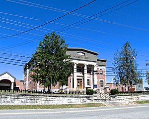
Campbell County Courthouse in Jacksboro
|
|||||
|
|||||

Location within the U.S. state of Tennessee
|
|||||
 Tennessee's location within the U.S. |
|||||
| Country | |||||
| State | |||||
| Founded | September 11, 1806 | ||||
| Named for | Arthur Campbell | ||||
| Seat | Jacksboro | ||||
| Largest city | LaFollette | ||||
| Area | |||||
| • Total | 498 sq mi (1,290 km2) | ||||
| • Land | 480 sq mi (1,200 km2) | ||||
| • Water | 18 sq mi (50 km2) 3.6%% | ||||
| Population
(2020)
|
|||||
| • Total | 39,272 |
||||
| • Density | 79/sq mi (31/km2) | ||||
| Time zone | UTC−5 (Eastern) | ||||
| • Summer (DST) | UTC−4 (EDT) | ||||
| Congressional districts | 2nd, 3rd | ||||
Campbell County is a county in the state of Tennessee, USA. It is located in the northern part of East Tennessee. In 2020, about 39,272 people lived there. The main town and county seat is Jacksboro. Campbell County is also part of the larger Knoxville area.
Contents
History of Campbell County
Campbell County was created in 1806. It was formed from parts of Anderson and Claiborne Counties. The county was named after Colonel Arthur Campbell. He was an important soldier during the American Revolutionary War.
A place called New Mammoth Cave, located near Jellico, was once used to mine saltpeter. Saltpeter is a key ingredient for making gunpowder. This mining happened during the War of 1812. Today, this cave is a safe home for bats, including the Indiana bat, which is an endangered species.
During the American Civil War, most people in Campbell County supported the Union. On June 8, 1861, they voted against Tennessee leaving the Union. Campbell County was the first county in Tennessee to create a Union Army group for the Civil War. They formed Company B of the 1st Tennessee Infantry in Jacksboro.
Geography of Campbell County
Campbell County covers about 498 square miles (1,290 square kilometers). Most of this area, about 480 square miles (1,243 square kilometers), is land. The remaining 18 square miles (47 square kilometers) are covered by water.
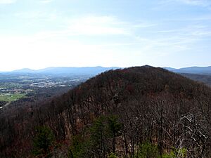
The county is located where the Cumberland Mountains meet the Appalachian Ridge-and-Valley Range. This area has many long hills and mountains. Some of these are Cross Mountain and Pine Mountain. The highest point is Cross Mountain, which is 3,534 feet (1,077 meters) tall.
Norris Lake is a large lake in the area. It was created in the 1930s by the Tennessee Valley Authority (TVA). The lake is fed by the Clinch and Powell Rivers. Another smaller lake, Cove Lake, is also part of the Norris project.
Most people in the county live in the southern part. This is where towns like La Follette, Jacksboro, and Caryville are located. Jellico is another important town, located near the border with Kentucky.
Neighboring Counties
- Whitley County, Kentucky (north)
- Claiborne County (east)
- Union County (southeast)
- Anderson County (south)
- Scott County (west)
- McCreary County, Kentucky (northwest)
Protected Natural Areas
- Chuck Swan State Forest (part)
- Cove Creek Wildlife Management Area
- Cove Lake State Park
- Cumberland Trail (part)
- Indian Mountain State Park
- Norris Dam State Park (part)
- North Cumberland Wildlife Management Area (part)
Population of Campbell County
| Historical population | |||
|---|---|---|---|
| Census | Pop. | %± | |
| 1810 | 2,668 | — | |
| 1820 | 4,244 | 59.1% | |
| 1830 | 5,110 | 20.4% | |
| 1840 | 6,149 | 20.3% | |
| 1850 | 6,068 | −1.3% | |
| 1860 | 6,712 | 10.6% | |
| 1870 | 7,445 | 10.9% | |
| 1880 | 10,005 | 34.4% | |
| 1890 | 13,486 | 34.8% | |
| 1900 | 17,317 | 28.4% | |
| 1910 | 27,387 | 58.2% | |
| 1920 | 28,265 | 3.2% | |
| 1930 | 26,827 | −5.1% | |
| 1940 | 31,131 | 16.0% | |
| 1950 | 34,369 | 10.4% | |
| 1960 | 27,936 | −18.7% | |
| 1970 | 26,045 | −6.8% | |
| 1980 | 34,923 | 34.1% | |
| 1990 | 35,079 | 0.4% | |
| 2000 | 39,854 | 13.6% | |
| 2010 | 40,716 | 2.2% | |
| 2020 | 39,272 | −3.5% | |
| U.S. Decennial Census 1790-1960 1900-1990 1990-2000 2010-2020 |
|||
2020 Census Information
| Race | Number | Percentage |
|---|---|---|
| White (non-Hispanic) | 37,101 | 94.47% |
| Black or African American (non-Hispanic) | 130 | 0.33% |
| Native American | 77 | 0.2% |
| Asian | 94 | 0.24% |
| Other/Mixed | 1,370 | 3.49% |
| Hispanic or Latino | 500 | 1.27% |
In 2020, there were 39,272 people living in Campbell County. They lived in 16,192 households, with 11,127 of these being families.
Economy of Campbell County
Coal Mining
The northern part of Campbell County is known for its coal. This area is part of a very large coalfield in the Appalachian Mountains. In the early 1900s, Campbell County was Tennessee's biggest coal producer. The coal found here was a special type that burned slowly.
Tourism
Tourism is very important to Campbell County. Norris Lake is a big draw, with 11 marinas that bring in many visitors each year. The county also has the Royal Blue Trails Complex, which is great for outdoor activities.
There are four state parks in Campbell County:
- Cove Lake State Park near Caryville
- Indian Mountain State Park near Jellico
- Norris Dam State Park near Rocky Top
- The Cumberland Trail
Many people also visit the Tennessee Welcome Center along I-75 at Jellico.
Communities in Campbell County
Cities
- Jellico
- LaFollette
- Rocky Top (partly in another county)
Towns
Census-designated place
Other Communities
See also
 In Spanish: Condado de Campbell (Tennessee) para niños


