
Carlile Shale facts for kids
Quick facts for kids Carlile ShaleStratigraphic range: Turonian ~93.9–89.8Ma |
|
|---|---|

Rare exposure of the Fairport Chalk member of the Carlile Shale in southern Ellis County, Kansas
|
|
| Type | Geological formation |
| Unit of | Colorado Group (lower); or Benton Formation |
| Sub-units | Juana Lopez (CO, NM) Codell Sandstone Blue Hill Shale Fairport Chalk |
| Underlies | Niobrara Formation |
| Overlies | Greenhorn Limestone |
| Thickness | 170–230 feet (52–70 m) |
| Lithology | |
| Primary | Shale, chalky to carbonaceous |
| Other | Limestone Sandstone Siltstone Septarians Bentonite |
| Location | |
| Coordinates | 38°22′34″N 104°58′44″W / 38.376°N 104.979°W |
| Region | Mid-continental |
| Country | |
| Type section | |
| Named for | Carlile Spring and Carlile Station, 21 mi west of Pueblo, Colorado |
| Named by | Gilbert |
| Year defined | 1896 |
The Carlile Shale is a special type of rock layer found in the central-western United States. It formed during the Cretaceous Period, about 93.9 to 89.8 million years ago. This rock layer is mostly made of shale, which is a type of rock formed from mud.
You can find the Carlile Shale in many states. These include Colorado, Kansas, Nebraska, New Mexico, North Dakota, South Dakota, and Wyoming. It was created from ancient ocean deposits. These deposits formed as a huge inland sea, called the Western Interior Seaway, slowly started to get smaller.
Contents
Exploring the Carlile Shale
The Carlile Shale can be seen in different places. For example, along Interstate 70 in Kansas, you can spot low hills made of this rock. These hills are mostly from the Fairport Chalk member, which is a part of the Carlile Shale. Its thin limestone layers make it tougher than other parts.
Near Yocemento, Kansas, you can see slopes of the Blue Hill Shale member. This part of the Carlile Shale is often blue-gray. In some areas, you might even find large, orange-tinted septarian boulders. These are round rocks with cracks inside.
Discovering Ancient Life: Carlile Shale Fossils
The Carlile Shale is a great place to find fossils! Scientists have discovered amazing remains of ancient creatures here.
What Fossils Are Found?
One exciting find in the Blue Hill Shale Member in Kansas is Plesiosaur remains. Plesiosaurs were large, marine reptiles with long necks. They swam in the ancient seas millions of years ago.
In eastern South Dakota, the Carlile Shale also holds other treasures. You can find shark teeth from ancient sharks. There are also fossils of wood and leaves, showing what plants were like back then. Ammonites, which were shelled creatures similar to modern-day Nautilus, are also common finds.
How Scientists Studied the Carlile Shale
Scientists have been studying the Carlile Shale for a long time. They wanted to understand how it formed and what it tells us about Earth's past.
Naming the Carlile Shale
The Carlile Shale was first named by a geologist named Grove Karl Gilbert. He named it in 1896 after Carlile Spring. This spring is located about 21 miles (34 km) west of Pueblo, Colorado. Gilbert described it as a gray shale with limestone or sandstone on top.
Later, in 1931, other geologists like William Walden Rubey mapped the Carlile Shale. They found it stretched into Kansas and the Black Hills. Rubey also linked it to a larger group of rocks called the Colorado Group. In 1948, C.H. Dane connected it to the Mancos Shale in New Mexico.
Gallery
-
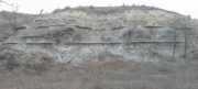
The lower 25 feet (7.6 m) of the Fairport Chalk member in southern Ellis County, Kansas.
-
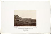
1867, bluffs west of Hays, behind the seated soldiers is pre-settlement digging in the Blue Hill Shale.
-
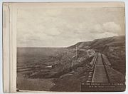
The bare Blue Hill Shale slopes at Yocemento as they appeared in 1873.

.jpg)
.jpg)
