Clarke Island (Tasmania) facts for kids
|
Native name:
lungtalanana
|
|
|---|---|

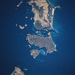
Lying below Flinders Island and Cape Barren Island is Clarke Island. The land mass at the bottom left corner is Tasmania.
|
|

Clarke Island (Tasmania)
|
|
| Geography | |
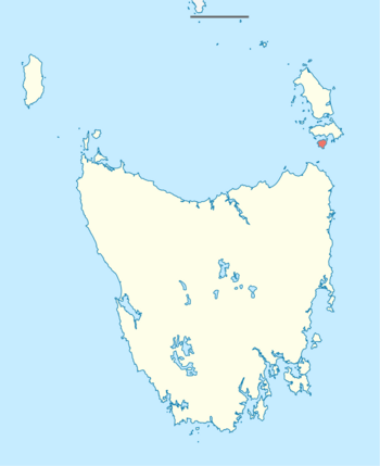
| Location | Bass Strait |
| Coordinates | 40°32′06″S 148°10′12″E / 40.535°S 148.170°E |
| Archipelago | Furneaux Group |
| Area | 82 km2 (32 sq mi) |
| Area rank | 8th in Tasmania |
| Highest elevation | 206 m (676 ft) |
| Administration | |
|
Australia
|
|
| State | Tasmania |
The Clarke Island, also known by its Aboriginal name of lungtalanana, is a special island in Bass Strait, Australia. It's part of the Furneaux Group of islands. Clarke Island is about 82 square kilometers (32 sq mi) in size. It lies south of Cape Barren Island, about 15 miles (24 km) off the northeast coast of Tasmania. The Banks Strait separates it from mainland Tasmania. Clarke Island is the third-largest island in the Furneaux Group. It is also Tasmania's eighth largest island overall.
Off its west coast, you can find the shipwreck of HMS Litherland. This ship sank in 1853 and was found again in 1983.
Contents
Island History
Early Days
Aboriginal Tasmanians have known Clarke Island as lungtalanana for a very long time. Aboriginal people lived on and used the land when it was connected to the mainland. This was before the last glacial period. It is thought that people lived there until about 6,500 years ago.
When sea levels rose, lungtalanana became an island. Aboriginal people stopped living there for a while. They did not return until sealers brought them there in 1810. They then lived mainly in huts around the area now called Spike Bay.
The Sydney Cove Shipwreck (1797)
The ship Sydney Cove got stuck near Preservation Island on February 28, 1797. A group of seventeen men left the ship in a small boat to get help. They hoped to reach Port Jackson, which was 400 nautical miles (740 km) away.
This group was led by Hugh Thompson, the first mate. It included William Clark, three European sailors, and twelve Indian sailors. Bad luck struck again, and their boat was wrecked on the mainland. This happened at the northern end of Ninety Mile Beach. Their only hope was to walk along the shore all the way to Sydney. This was a distance of over 600 kilometers (370 mi).
They had little food and no weapons. People became tired and hungry, and their group got smaller as they walked. Along the way, they met different Aboriginal Tasmanians. Some were friendly, and some were not. The last person to die on the walk was killed by a man named Dilba and his people. These people were known for being fierce around Port Jackson.
In May 1797, three survivors made it to a cove at Wattamolla. These were William Clark, sailor John Bennet, and one Indian sailor. On May 15, 1797, they were very weak. They managed to signal a fishing boat, which took them to Sydney.
During the walk, William Clark noticed coal in the cliffs. This was at a place now called Coalcliff, between Sydney and Wollongong. This was the first coal ever found in Australia. When they arrived at Port Jackson, the men told Governor Hunter about the Sydney Cove. They also told him about the remaining crew and cargo. Governor Hunter sent two ships, the Francis and the Eliza, to rescue the ship and its crew.
On the first rescue trip, the crew of the Francis found wombats on the island. A live wombat was taken back to Port Jackson. Matthew Flinders, who was on the Francis for its third trip, also took a wombat from the island. Governor Hunter later sent the wombat's body to Joseph Banks. This was to confirm it was a new animal species. Flinders also saw many fur seals on the island in 1798.
The island was later named Clarke Island, after William Clark.
The HMS Litherland Shipwreck (1853)
The ship HMS Litherland sank off the coast of Clarke Island in 1853. Its wreck was discovered in 1983.
Later Uses of the Island
Sealing happened on the island from 1810 until 1837. From 1843 onwards, farmers brought livestock to the island. They raised sheep and cattle there. This European use of the island brought new animals, weeds, and plant diseases.
Handback to Aboriginal People
In 1995, the Aboriginal Land Council of Tasmania bought a large area of land on the island. This was done under a lease agreement.
In 1997, Aboriginal people gained some control over Clarke Island. It became known to them as lungtalanana. This name comes from an Aboriginal woman named Tanalipunya. She had been taken to the Bass Strait Island by white sealers. Her skills were very important in helping the sealers survive. During this time, the island was used for youth justice programs. These programs offered an alternative to prison for young Aboriginal offenders. Some families lived on the island to help run these programs.
On May 10, 2005, the government officially handed over Crown lands on Clarke Island to Aboriginal people. This was a very important moment. It was the first official handover of Crown land to an Aboriginal community in Tasmania. The Aboriginal Land Council of Tasmania now oversees these lands.
In 2009, Clarke Island had one person living there all the time. Small groups of up to eight people visited for youth programs. The island's buildings were old. In 2009, a new power system was installed. It uses 2kW solar and 1kW wind energy to make electricity. This replaced an old diesel generator that cost a lot to run.
Also in 2009, the island was named an Indigenous Protected Area (IPA). This helps protect its natural and cultural values.
Location and Geography
Clarke Island is part of the Furneaux Group. It is an 82 square kilometer (32 sq mi) island in Bass Strait. It lies south of Cape Barren Island, about 15 miles (24 km) off the northeast coast of Tasmania, Australia. The Banks Strait separates the island from Cape Portland on the mainland.
Clarke Island is Tasmania's eighth largest island. It is also the third largest in the Furneaux Group.
Island Shape and Features
A main feature of Clarke Island is a central plateau. This high area rises about 350 feet (110 m). It collects some water, which then flows to the sea. The highest point on the island is about 676 feet (206 m) high. It is located on the northwestern part of the island.
There are three main hills: Blue Hills in the east, Green Hill in the southwest, and Steep Hill in the northwest. Along the coastline, there are wet areas. The coast has rocky parts with white beaches in between them. On the eastern side of the island, there is a line of white beaches in the Rutherford Cove area.
Human Access and Life
Many old sites on the island show signs of Aboriginal people living there. They used the land for a very long time.
The main settlement is in the northwest corner. It has several buildings and an airstrip for small planes.
Nature, Plants, and Animals
In the early 1800s, Clarke Island had many eucalypt trees and sheoaks (called limuna). The sheoaks grew in a belt close to the shore. A lot of damage happened to the native plants. This was after about 4000 sheep grazed on the island. During this time, no cultural burning took place. This led to several damaging bushfires. Grazing stopped in 2005 after the island was handed back to the local Aboriginal people. But the damage is still there in the 2020s. The pastures are only slowly growing back. A big fire in 2014 burned about 98% of the island's plants.
The Xanthorrhoea australis (yamina, or "black boy") forest on the island is very important. It is part of a special ecosystem. There is a forest of very old yamina in the northern part of the island. These plants are important to the community. Their leaves can be used for weaving. They grow very slowly. People were worried about them after so many burned in the 2014 fire. But they can recover well after a fire.
A survey in 2014, done eight months after the fire, found that most plant species were growing back well. But they were still at risk from more fires or dry weather. The survey also found eight types of land mammals on the island. Six of these were introduced animals. Only two native species were found. This was only 20 percent of the native mammals seen before.
Clarke Island is the only place in Tasmania where the Australian pelican breeds. Small islands around Seal Point provide important homes for the threatened white-fronted tern.
Threats to the Island
Animals that were brought to the island and still live there include rabbits, cats, and rats. The cats likely caused the remaining small native mammals to disappear from the island.
A root fungus called Phytophthora cinnamomi was found on the island in 2002. This disease can kill Australian native plants. It rots the roots of plants. By 2015, this disease had spread and was a concern. It especially threatened the yamina forest. This disease can be carried by dirty soil on machines or clothes.
Protecting the Island
Reports are published regularly. Plans are in place to keep the island's natural systems healthy. The Aboriginal Land Council of Tasmania gives advice for managing weeds and diseases. They also help protect plant species that are at risk.
In January 2023, a project started to remove the feral cats. This is to protect a group of vulnerable white-fronted terns (Sterna striata) nesting on the island. Because it is an IPA, the island gets some money from the government. This money helps pay for Indigenous rangers to manage the land. WWF-Australia has also given money to the island. This money is for bringing back native animals.
A project to move several animal species to the island is planned for mid-2025. It will start with Bass Strait wombats from Flinders Island and Maria Island. It is hoped that Bennetts wallabies and long-nosed potoroos will be next. This will happen once the cat population is controlled. Wombats create burrows, which can cool the earth and provide shelter for smaller animals.


