
Corsham facts for kids
Quick facts for kids Corsham |
|
|---|---|
 Town Hall and Post Office at the High street |
|

Corsham
|
|
| Population | 13,369 (2021 census) |
| OS grid reference | ST873706 |
| Civil parish |
|
| Unitary authority |
|
| Ceremonial county | |
| Region | |
| Country | England |
| Sovereign state | United Kingdom |
| Post town | Corsham |
| Postcode district | SN13 |
| Dialling code | 01249 01225 |
| Police | Wiltshire |
| Fire | Wiltshire |
| Ambulance | Great Western |
| EU Parliament | South West England |
| UK Parliament |
|
Corsham is a historic town in west Wiltshire, England. It sits at the edge of the Cotswolds hills. You can find it just off the A4 main road. Corsham is about 28 miles (45 km) southwest of Swindon and 8 miles (13 km) northeast of Bath.
Long ago, Corsham was a farming area. Later, it became known for making wool. Today, it's still important for quarrying Bath Stone, a special type of rock. The town has many old buildings, like the grand stately home called Corsham Court.
During the Second World War and the Cold War, Corsham became a big center for the Ministry of Defence. Many military sites were built here, some even hidden in old quarry tunnels! The area around Corsham also includes the villages of Gastard and Neston.
Contents
- History of Corsham
- What to See and Do
- Villages in the Parish
- Important Buildings
- How Corsham is Governed
- Population and People
- Education in Corsham
- Churches in Corsham
- Getting Around Corsham
- Town Twinning
- Economy: How Corsham Makes Money
- Media and News
- Sports and Fun
- Famous People from Corsham
- Images for kids
- See also
History of Corsham
The name Corsham likely comes from Cosa's hām. "Hām" is an Old English word for a homestead or village. In the old Domesday book, the town was called Cosseham. The letter 'R' was probably added later when the Normans arrived.
During the Anglo-Saxon times, the King owned the Corsham area. It had a large forest, which was later cleared for farms. Some people even called it "Corsham Regis," meaning "King's Corsham." This name is still used by a local primary school.
Corsham became rich during the Middle Ages because of the wool trade in Wiltshire. Even after the wool trade slowed down, the town stayed wealthy. This was thanks to the quarrying of Bath stone, which was mined underground south and west of Corsham. The main road from London to Bristol (now the A4) also passed through the town, helping it to grow.
Many old buildings on the High Street are very special. Numbers 94 to 112 are called the "Flemish Weavers Houses." However, it's more likely that a few Dutch workers settled here in the 1600s. The Grove and The Ivy are great examples of classic Georgian-style buildings. The High Street alone has over 60 buildings listed as historic!
What to See and Do

Corsham's town center has a historic High Street. It also has the Martingate Centre, which is a shopping area built in the late 1900s.
Right in the town center, you'll find the beautiful Corsham Court. This grand house stands on what was once a Saxon Royal Manor. The main house was built in 1582. Since 1745, it has belonged to the Methuen family.
Corsham Court has an amazing collection of old paintings. Its rooms were designed by famous artists like Robert Adam and Thomas Chippendale. The gardens were planned by well-known landscape designers, Capability Brown and Humphry Repton. You can visit the house almost all year round. It's famous locally for its peacocks, which often wander around the streets!
In the 1600s, Sir Edward Hungerford owned Corsham Court. His wife, Lady Margaret Hungerford, built the Hungerford Almshouses in the town center. These were homes for people who needed help.
Community Fun
The Pound is a lively arts center and community hub for the area. It hosts many events, including music and comedy. The Pound Arts Trust also organizes two yearly festivals:
- The Blue Sky Festival in June, which celebrates different art forms.
- The Magic and Mayhem Festival in November, featuring magic, burlesque, and other exciting performances.
Villages in the Parish
The Corsham parish includes several smaller villages and hamlets.
Gastard Village
The village of Gastard has been a settlement since the 1100s. It has a church built in the 1900s.
Neston Village
Neston village grew up around Neston Park. This is a large country estate with a house built around 1790. Neston Park is home to the Fuller family. They are known for the Fuller, Smith and Turner brewery in London, which makes the famous Fuller's London Pride cask ale.
Pickwick Village
Pickwick was once a separate village but is now part of Corsham. Its name comes from old Anglo-Saxon words: pic (meaning a peak or pointed hill) and wic (village).
Interestingly, Corsham inspired Charles Dickens' famous novel The Pickwick Papers. It's thought that Dickens got the name from Moses Pickwick. He was a coachman born in Pickwick who ran coaches between Bath and London.
Other Nearby Areas
North of the A4 road, you'll find the small areas of Middlewick, Upper Pickwick, and Cross Keys.
Other settlements now part of Corsham include Hudswell, Leafield, Westwells with Moor Green, and Neston further south. To the east are Easton, Thingley, and Westrop. In the southeast, you'll find Chapel Knapp, Gastard, Monk's Park, The Linleys, and The Ridge.
Important Buildings
Pickwick Manor, on Bath Road, is a very impressive manor house from the late 1600s. It even has parts of a 1300s wing! More recently, this historic house has been home to architect Harold Brakspear and his family.
Beechfield is a beautiful late Georgian house. Part of its grounds were turned into a nature area in 2002. Here, you can see local plants and animals. Nearby, Guyers House is a 1600s house that is now a hotel and restaurant.

Middlewick House, just outside town, was once home to Camilla Parker Bowles (who later became Queen Camilla). In 1995, Nick Mason from the band Pink Floyd bought it. Further north, Hartham Park is another Georgian estate. Rudloe Manor, a 1600s manor house, is also nearby.
How Corsham is Governed
For national elections, Corsham is part of the Chippenham area. Since 2024, Sarah Gibson from the Liberal Democrats has represented this area in Parliament.
Since 2009, Corsham has been part of Wiltshire Council, which manages local services. Voters in Corsham elect three councillors to this council.
Corsham also has its own local government called Corsham Town Council. It was formed in 1895. Even though Corsham never officially received a "town charter," it became a town council in 2000. There are currently twenty councillors who help run the town.
Population and People

In 1801, the first official count showed Corsham had 2,402 people. By 2011, the population had grown to exactly 13,000! The big jump in population around 1840 was because many stone workers moved here. The Great Western Railway also arrived around that time.
No count was taken in 1941 due to the Second World War. However, the population grew a lot between 1931 and 1951. This was because many military people moved to Corsham during and after the war.
In 2001, Corsham's population was similar to the rest of the country. The unemployment rate was lower than the national average. More people in Corsham had degrees compared to the national average.
Education in Corsham
Corsham has four primary schools, one independent school, and a large secondary school. Primary schools teach students up to age 11:
- Corsham Primary School is split between two sites. It was formed from several older schools and now teaches about 680 students.
- Corsham Regis Primary Academy opened in 1943 for children of military workers. It now has about 150 students.
- Neston Primary School was founded in 1861. It now teaches about 200 students.
- St Patrick's Catholic Primary School opened in 1966 and has about 190 students.
Some students from Corsham also go to primary schools in nearby Box and Shaw.
The Corsham School is the only secondary school in Corsham. It opened in 1972 and is now a large academy with a sixth form (for older students). In July 2024, it had 1,264 students.
Heywood Prep School is an independent school for children aged 2 to 11. It has about 260 students. The school is located on a historic site in the center of Corsham, near Corsham Court. The main building is a beautiful Georgian building from 1776.
An early school in Corsham was set up by Lady Margaret Hungerford in 1668. A new schoolroom was built in 1816. This building is still standing and is now used as a college center.
Churches in Corsham
Former Priory
Corsham once had a priory, which was a type of monastery. It was mentioned in 1336. Later, a Georgian house was built on the site, which is now part of Heywood Prep School.
Anglican Churches

The main church in Corsham is the Church of St Bartholomew. It stands between the High Street and Corsham Court. Parts of the church are built on very old Saxon foundations. The church has parts from the 1100s, but it was greatly rebuilt in the late 1800s.
The church has a tall tower with a spire. Inside, you can see old Norman arches and a roof from the 1400s. In 1960, the church was recognized as a Grade I listed building, meaning it's very important historically.
Churches in Nearby Villages
The Church of St Philip and St James in Neston opened in 1866. Its design is in the early English Gothic style.
The Church of St. John the Baptist in Gastard was built in 1912 in the gothic style.
Roman Catholic Church
St. Patrick's Roman Catholic Church opened in 1945. It used to be the Pickwick school, built in 1858. Before becoming a church, it was also used as a glove factory and a gas mask factory!
Monk's Chapel
Monk's Chapel, built near Gastard in 1662, was first a Quaker meeting-house. It later became a Congregational church. This chapel is a Grade I listed building and is still used today.
Other Churches
- The Baptist Chapel at Moor Green was founded in 1833.
- Ebenezer Baptist Chapel at Velly was founded in 1857.
- The Congregational Church on Pickwick Road started in 1790. It closed in 1971 and is now used as offices.
- Ebenezer Chapel on Priory Street opened in 1829. It is now Corsham Baptist Church.
- Zion Hill Baptist Chapel was built in 1859 by a group who left the Priory Street chapel.
- A large Wesleyan Methodist chapel was built on Pickwick Road in 1903. In 1984, it joined with the nearby Congregational church to form the United Church of St Aldhelm, which is still in use.
Getting Around Corsham

Corsham is connected to other towns by roads like the B3109 to Bradford on Avon and the A4 to Chippenham and Bath. Junction 17 of the M4 motorway is about 8 miles (12 km) away. Local buses run by Faresaver connect Corsham to nearby towns.
The Great Western Main Line railway, which goes from London to Bristol and beyond, passes through Corsham. However, Corsham station closed in 1965. There have been talks about reopening the station since 2009. In 2021, a study was approved to see if it's possible.
The closest active train stations are Melksham, about 4.5 miles (7.2 km) away, and Chippenham, about 4.7 miles (7.6 km) away. Chippenham offers more frequent express train services.
The eastern entrance of Box Tunnel is on the western edge of Corsham. This was the longest railway tunnel of its time, built by the famous engineer Isambard Kingdom Brunel. The railway line also passes through the Corsham Railway Cutting, which is a special scientific site because of its unique geology.
Town Twinning
.jpg)
Corsham has a special "twinning" relationship with the town of Jargeau, France. This partnership started in 1981. There's an active group that organizes events to celebrate this friendship, including music, charity events, and French food. They even have a boules competition! In 2008, they staged a pretend Storming of the Bastille to celebrate Bastille Day, with Corsham Town Hall acting as the famous Parisian prison.
Economy: How Corsham Makes Money
Defence Industry
The Ministry of Defence (MoD) has had many sites around Corsham since the First World War. About 2,000 people work for the MoD here. Several of these defense sites are underground, built in old Bath Stone quarries. The largest above-ground sites are in the Hawthorn area.
Basil Hill Site
The Basil Hill site is now called MOD Corsham. It has about 2,100 people working there. It's home to the UK's Defence Digital organization and the Ministry of Defence's Global Operations Security Control Centre.
Rudloe Site
The Rudloe site was once part of RAF Rudloe Manor. It was set up during the Second World War for administrative and command purposes. It was also the main entrance for a secret government wartime headquarters. Today, it's part of Joint Support Unit Corsham.
Hawthorn Site
The Hawthorn site helps support the Skynet military communications satellites. These satellites help with military communications around the world.
Copenacre Site
The Copenacre site used to be an underground stone quarry. The Ministry of Defence took it over in 1937 and used it as a Royal Naval Stores Depot. The underground stores closed in 1995, and the whole site closed in 2011. It's now being redeveloped for housing.
Other Defence Units
The Joint Support Unit helps manage all these MoD locations. The Corsham Computer Centre is a Royal Navy facility for data processing.
The Services Cotswold Centre in Neston is a welfare center. It offers temporary housing for military families who need it. It has 63 family units and a medical center.
HMS Royal Arthur was a naval training base here from 1947 to 1993. Many defense companies also have offices near the MoD sites.
Quarries
Underground quarrying of Bath Stone still happens in Corsham, though on a smaller scale than before. Hanson plc operates Hartham Park Quarry and Monk's Park Quarry.
Old, unused quarries have found new uses. Besides defense, one quarry at Eastlays is now a wine storage facility. Another at Neston stores magnetic media for data protection.
Film and Television
The old quarries are also used by the film industry! Underground scenes for the TV show Blake's 7 were filmed at Eastlays. Some disused tunnels are now part of Corsham Media Park, a business park for film and media companies.
Corsham is also a popular place for filming period dramas. Neston Park was used for outdoor scenes in the 2008 BBC show Lark Rise to Candleford. The BBC also filmed parts of Tess of the D'Urbervilles in Church Street and at Corsham Court.
Corsham Court itself has been a filming location for many productions, including Barry Lyndon (1975), The Remains of the Day (1993), and Wives and Daughters (1999).
From 2014 to 2019, scenes for the TV show Poldark were filmed on Corsham's High Street.
Media and News
You can get local news and TV programs from BBC West and ITV West Country.
Local radio stations include BBC Radio Wiltshire (104.3 FM), Heart West (102.2 FM), Greatest Hits Radio South West (107.5 FM), and Kik Radio, which is an online community radio station.
The local newspapers are the Gazette and Herald and Wiltshire Times.
Sports and Fun
Corsham has a non-League football club called Corsham Town F.C.. They were founded in 1884 and play at Southbank. In 2007, they finished first in the Western Football League Premier Division.
Famous People from Corsham
- Decca Aitkenhead (b. 1971), a journalist for The Guardian.
- Felix Aylmer (1889–1979), an actor.
- Jennifer Biddall (b. 1980), an actress known for Hollyoaks.
- Queen Camilla (b. 1947) and her first husband lived at Middlewick House.
- Harold Brakspear (1870–1934), a famous architect and archaeologist.
- Elizabeth Hurley (b. 1965), an actress, attended St Patrick's Primary School for a short time.
- Kris Marshall (b. 1973), an actor known for My Family and Death In Paradise.
- Nick Mason (b. 1944), musician from Pink Floyd, lives at Middlewick House.
- The Baron Methuen family, whose home is Corsham Court.
- Michael Tippett (1905–1998), a famous composer, lived in Corsham from 1960 to 1970.
Images for kids
-
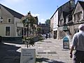
The historic High Street is typical of a Cotswold town
-
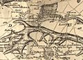
A 1773 map shows Neston's earlier name of Corsham Side
-
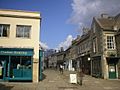
The southern portion of the High Street is pedestrianised


See also
 In Spanish: Corsham para niños
