
Danville, California facts for kids
Quick facts for kids
Town of Danville
|
|||
|---|---|---|---|

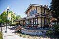
Museum of the San Ramon Valley, pictured in 2021
|
|||
|
|||
| Mottoes:
Live Locally
"Heart of the San Ramon Valley" |
|||

Location of Danville in Contra Costa County, California
|
|||

Danville, California
Location in the United States
|
|||
| Country | United States | ||
| State | California | ||
| County | Contra Costa | ||
| Incorporated | July 1, 1982 | ||
| Area | |||
| • Total | 18.08 sq mi (46.82 km2) | ||
| • Land | 18.08 sq mi (46.82 km2) | ||
| • Water | 0.00 sq mi (0.00 km2) 0% | ||
| Elevation | 358 ft (109 m) | ||
| Population
(2020)
|
|||
| • Total | 43,582 | ||
| • Density | 2,410.78/sq mi (930.82/km2) | ||
| Time zone | UTC-8 (Pacific) | ||
| • Summer (DST) | UTC-7 (PDT) | ||
| ZIP codes |
94506, 94526
|
||
| Area code | 925 | ||
| FIPS code | 06-17988 | ||
| GNIS feature IDs | 277497 2412403 | ||

Danville is a charming town located in the San Ramon Valley in Contra Costa County, California. It's special because it's one of the few places in California that uses "town" in its name instead of "city". In 2020, about 43,582 people lived here. For five years in a row, Danville has been known as "the safest town in California."
The Iron Horse Regional Trail is a popular spot in Danville. This trail used to be a railroad, but now it's a wide path for biking and hiking. It stretches from Livermore to Concord, passing right through Danville.
Danville is also home to some cool places like the Eugene O'Neill National Historic Site, the Village Theatre and Art Gallery, and the Museum of the San Ramon Valley.
Contents
Discovering Danville's Past
.jpg)
Danville is often called the "Heart of the San Ramon Valley." Long ago, Native Americans lived here, especially near creeks and on Mount Diablo during summer. Later, the land was used for grazing by Mission San José and was part of a Mexican land grant called Rancho San Ramon.
From Farms to a Modern Town
Danville started as a farming community. Farmers grew wheat, but after the Southern Pacific Railroad built tracks here in 1891, they switched to growing fruits and nuts. The town began to grow as a place for people to live in 1947, when the first big housing areas were built. Its population grew a lot in the 1970s and 1980s.
The Danville Post Office opened in 1860. Henry W. Harris, a hotel owner, was the first postmaster. As the community grew, churches, schools, and other groups started up. The Union Academy, a private high school, served the area from 1859 to 1868. The Danville Presbyterian Church was built in 1875.
Many old buildings from Danville's early days are still standing. The original 1874 Grange Hall is still here, and the old Danville Hotel is downtown. Many streets and schools are named after the early pioneer families, like Baldwin, Harlan, and Wood.
When the Southern Pacific Railroad arrived in 1891, Danville kept growing. Farmers used the trains to ship their crops, and people could travel easily. John Hartz sold some of his land for the Danville Depot. He then sold smaller plots of land near the station, which made the town's main area shift from Front Street to Hartz Avenue. Soon, a bank, a drug store, and other businesses joined the homes along the street.
Danville in the 20th Century
In the 1900s, Danville was affected by big events like wars and the Great Depression. In 1910, a public high school, San Ramon Valley Union High School, was built. A library opened in 1913 with 104 books. St. Isidore's Catholic Church was founded in 1910. In 1915, an Improvement League helped fund the first streetlights and paved roads.
Danville remained mostly farmland into the 1940s. The population grew from 2,120 people in 1940 to 4,630 by 1950. New housing areas like Montair and Cameo Acres were built. The water and sewer systems expanded, and the new I-680 freeway was built through Danville in the mid-1960s.
In 1982, the people of Danville voted to officially become an incorporated town. By 2000, Danville's population reached 40,484. In 2022, Danville was named the safest city in California for the fifth year in a row.
Exploring Danville's Geography

Danville is located in a narrow part of the San Ramon Valley. To the west is the Las Trampas Ridge, and to the east is the Diablo Range. The most famous landmark is Mount Diablo, which stands tall at 3,849 feet (1,173 meters) to the east. It creates a beautiful view for Danville and nearby towns. Sycamore Creek flows through Danville, draining water from Mount Diablo.
To the north of Danville is the town of Alamo. To the south, San Ramon borders Danville. Both are nice suburbs.
Interstate 680 is the main highway that runs through the valley, making it easy to travel in and out of town. Camino Tassajara is another important road for traveling east and west, especially to reach neighborhoods further east. It also leads to the community of Blackhawk.
Danville covers an area of about 18.0 square miles (46.8 square kilometers), and it's all land.
Danville's Climate and Weather
Danville has a Mediterranean climate. This means summers are long, with hot days and cool nights. Winters are cool, with mild daytime temperatures, usually around 50 degrees Fahrenheit (10 degrees Celsius). Nighttime temperatures usually stay above freezing.
Like other parts of the Bay Area, summers in Danville are very dry. It's common for months to pass between the last rain in spring and the first rain in fall. Winters are rainy, but even in the middle of winter, there are often several days or a week of mild, dry, and sunny weather.
| Climate data for Danville, California (1981–2010 normals) | |||||||||||||
|---|---|---|---|---|---|---|---|---|---|---|---|---|---|
| Month | Jan | Feb | Mar | Apr | May | Jun | Jul | Aug | Sep | Oct | Nov | Dec | Year |
| Mean daily maximum °F (°C) | 55.8 (13.2) |
60.4 (15.8) |
64.7 (18.2) |
69.4 (20.8) |
74.3 (23.5) |
79.5 (26.4) |
84.6 (29.2) |
84.1 (28.9) |
81.5 (27.5) |
74.6 (23.7) |
64.5 (18.1) |
56.3 (13.5) |
70.8 (21.6) |
| Daily mean °F (°C) | 47.5 (8.6) |
51.2 (10.7) |
54.2 (12.3) |
57.5 (14.2) |
62.0 (16.7) |
66.6 (19.2) |
70.2 (21.2) |
70.1 (21.2) |
68.3 (20.2) |
62.5 (16.9) |
54.2 (12.3) |
47.9 (8.8) |
59.3 (15.2) |
| Mean daily minimum °F (°C) | 39.2 (4.0) |
41.9 (5.5) |
43.6 (6.4) |
45.4 (7.4) |
49.7 (9.8) |
53.6 (12.0) |
55.9 (13.3) |
56.1 (13.4) |
55.0 (12.8) |
50.5 (10.3) |
44.0 (6.7) |
39.5 (4.2) |
47.9 (8.8) |
| Average precipitation inches (mm) | 4.86 (123) |
4.90 (124) |
3.67 (93) |
1.46 (37) |
0.88 (22) |
0.16 (4.1) |
0.03 (0.76) |
0.08 (2.0) |
0.20 (5.1) |
1.28 (33) |
3.06 (78) |
4.57 (116) |
25.14 (639) |
| Source: PRISM Climate Group | |||||||||||||
People and Community
| Historical population | |||
|---|---|---|---|
| Census | Pop. | %± | |
| 1960 | 3,585 | — | |
| 1970 | 14,059 | 292.2% | |
| 1980 | 26,446 | 88.1% | |
| 1990 | 31,306 | 18.4% | |
| 2000 | 41,715 | 33.2% | |
| 2010 | 42,039 | 0.8% | |
| 2020 | 43,582 | 3.7% | |
| 2022 (est.) | 42,732 | 1.6% | |
| source: | |||
Danville is known as one of the wealthiest areas in America. It's a very well-off suburb of Oakland and San Francisco. Many households in Danville have high incomes.
In 2020, Danville's population was 43,582. Most residents are White, but there's also a growing number of Asian and Hispanic or Latino residents, along with people from other backgrounds. The town is home to many families, with a good number of households having children under 18.
Arts and Culture in Danville

Museums and Historic Places
- Eugene O'Neill National Historic Site – This is also known as Tao House.
- Museum of the San Ramon Valley – Located in the old 1891 Southern Pacific train station.
- Blackhawk Museum
- All Wars Memorial – Found in Oak Hill Park, built in 2005.
- Veterans Memorial Building of San Ramon Valley
Libraries for Learning
The Danville Library is part of the Contra Costa County Library system. It's one of the busiest libraries in the county, meaning lots of books are checked out here!
Fun Seasonal Events
- The Kiwanis Fourth of July parade brings over 40,000 people each year.
- The Devil Mountain Run happens every March. It's a 10k, 5k, or 1-mile run that starts in Downtown Danville.
- Hot Summer Sundays Car Shows are held on Hartz Avenue in Downtown Danville one Sunday in September. You can see hundreds of cool vintage cars from before the 1960s and enjoy live music.
- The Annual Lighting of the Old Oak Tree (LOOT) takes place on Diablo Road every year the Friday after Thanksgiving.
Parks and Recreation
Danville has many parks and outdoor spaces for everyone to enjoy.
- Mount Diablo State Park
- Las Trampas Regional Wilderness
- Front Street Park
- Baldwin School Park
- Danville South Park
- Diablo Vista Park
- Green Valley School Park
- Greenbrook School Park
- Montair School Park
- Oak Hill Park
- Osage Station Park
- Sycamore Valley Park
- Hap Magee Ranch Park
- Bret Hart Park
Education in Danville
Public Schools
Danville schools are part of the San Ramon Valley Unified School District.
- (John) Baldwin Elementary School
- Del Amigo High (Continuation)
- Diablo Vista Middle School
- Creekside Elementary School
- Green Valley Elementary School
- Greenbrook Elementary School
- Los Cerros Middle School
- Montair Elementary School
- Monte Vista High School
- Sycamore Valley Elementary School
- Tassajara Hills Elementary School
- Vista Grande Elementary School
- Charlotte Wood Middle School
- San Ramon Valley High School
Private Schools
- San Ramon Valley Christian Academy (Christian)
- St. Isidore's School (Roman Catholic)
- The Athenian School (non-denominational)
- Danville Montessori School
Famous People from Danville
Many well-known people have lived in or are from Danville:
- Alissa Anderegg – Miss World America 2020
- Billy Beane – Former baseball player and executive for the Oakland Athletics, known from the book and movie Moneyball
- Doug Bowser – Businessman, president of Nintendo of America
- D'Arcy Carden – Actress, known for The Good Place
- Leroy Chiao – Astronaut
- E-40 – Rapper
- Ellise – Singer and musician
- Elizabeth Emken – Politician
- Zach Ertz – Tight end for NFL's Arizona Cardinals; went to Monte Vista High School
- Draymond Green – Power forward for NBA's Golden State Warriors
- Kyle Harrison (born 2001) – Baseball pitcher for the San Francisco Giants
- Dallas Jaye – Soccer player
- George Komsky – Ukrainian-born singer
- Duane Kuiper – Former baseball player and broadcaster for the San Francisco Giants
- Nate Landman – NFL linebacker; went to Monte Vista High School
- Jason Lucash – Inventor of Origaudio
- Mark Madsen – NBA player and coach; went to San Ramon Valley High School
- Judah Miller – Screenwriter and producer
- Murray Miller – Screenwriter and producer
- Joe Morgan – Baseball Hall of Fame second baseman
- Bob Myers – General manager of the NBA champion Golden State Warriors
- Vince Neil – Singer for Mötley Crüe
- Jeff Newman – MLB All-Star baseball catcher and manager
- Evan O'Dorney – Winner of the 80th Scripps National Spelling Bee in 2007
- Eugene O'Neill – The only Nobel Prize-winning American playwright. He wrote some of his best plays while living at Tao House (now the Eugene O'Neill National Historic Site) from 1937 to 1944.
- Greg Papa – Broadcaster for the San Francisco 49ers
- A. J. Puckett – Baseball pitcher for Chicago White Sox
- Marchmont Schwartz (1909–1991) – College football player and coach
- Nate Schierholtz – Baseball player; went to San Ramon Valley High School
- Adam Schiff – U.S. Representative; went to Monte Vista High School
- Russell Simpson – Actor
- Greg Sestero – Actor; went to Monte Vista High School
- Gale Storm – Actress and singer
- Chesley B. "Sully" Sullenberger – Pilot who safely landed US Airways Flight 1549 in the Hudson River, saving all 155 people on board.
- Nancy Tellem (born 1952) – Chief media officer
- Mark Tollefsen (born 1992) – Basketball player
- Christy Turlington – Supermodel; went to Monte Vista High School
- Dana Vollmer – Olympic swimmer, gold medalist in 2004, 2012, and 2016
- Joey Wagman – Baseball pitcher
- Andre Ward – Professional boxer
- Randy Winn – MLB outfielder
- Chris Wondolowski – Soccer player for San Jose Earthquakes and the United States men's national soccer team
- Kevin Woo – Singer for the band U-KISS
- David Zuckerman – Writer and producer of Family Guy
Images for kids
-
Museum of the San Ramon Valley
-

Seal of Danville
-
Logo of Danville
-
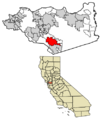
Location of Danville in Contra Costa County, California
See also
 In Spanish: Danville (California) para niños
