
Doubs facts for kids
Quick facts for kids
Doubs
|
|||
|---|---|---|---|
_(adjusted).jpg)
Prefecture building of the Doubs department, in Besançon
|
|||
|
|||

Doubs in France
|
|||
| Country | France | ||
| Region | Bourgogne-Franche-Comté | ||
| Département | 4 March 1790 | ||
| Prefecture | Besançon | ||
| Subprefectures | Montbéliard, Pontarlier | ||
| Area | |||
| • Total | 5,232.6 km2 (2,020.3 sq mi) | ||
| Population
(2014)
|
|||
| • Total | 534,710 | ||
| • Density | 102.1882/km2 (264.666/sq mi) | ||
| Demonym(s) | Doubistes | ||
| Time zone | UTC+1 (CET) | ||
| • Summer (DST) | UTC+2 (CEST) | ||
| ISO 3166 code | FR-25 | ||
| Arrondissements | 3 | ||
| Cantons | 19 | ||
| Communes | 578 | ||
| Website | www.doubs.fr | ||


Doubs is a department in eastern France. It is in the Bourgogne-Franche-Comté region. It is named after the Doubs river.
The largest city in the department, and its prefecture (capital), is the city of Besançon.
Contents
History
Doubs is one of the original 83 departments created during the French Revolution on 4 March 1790 with Besançon as its capital. It was formed from part of the old province of Franche-Comté.
It was divided in six districts: Besançon, Baume-les-Dames, Saint-Hippolyte, Pontarlier, Quingey and Ornans. In 1800, with the creation of the arrondissements in France, the six districts were changed into four arrondissements: Besançon, Baume-les-Dames, Pontarlier and Saint-Hippolyte. In 1816, the subprefecture of Saint-Hippolyte is moved to Montbéliard.
After the Battle of Waterloo (18 June 1815), the department was occupied by the Austrian army from June 1815 to November 1818.
On 10 September 1926, the arrondissement of Baume-les-Dames was eliminated.
Geography
Doubs is part of the Bourgogne-Franche-Comté region. It has an area of 5,232.6 km2 (2,020 sq mi).
The department borders with 3 departments of the Bourgogne-Franche-Comté region (Jura, Haute-Saône and Territoire de Belfort) and 3 cantons of Switzerland (Vaud, Neuchâtel and Jura).
The Doubs department is partially on the Jura Mountains, mainly the eastern part of the department on the border with Switzerland. The highest point in the department is Mont d'Or (46°44′0″N 6°21′24″E / 46.73333°N 6.35667°E), 1,461 m (4,793 ft) high; it is on the border between the communes Jougne and Longevilles-Mont-d'Or at about 20 km (12 mi) to the south of the city of Pontarlier. The lowest point is where the Ognon leaves the department, 200 m (660 ft) high.
The main rivers in the department are the Doubs, that gives its name to the department, the Ognon and the Loue (tributary of the Doubs).
Climate
The Köppen climate classification type for the climate at Besançon is an "Oceanic climate" (also known as Marine West Coast Climate) and of the subtype Cfb.
The average temperature for the year in Besançon is 11 °C (52 °F). The warmest month, on average, is July with an average temperature of 19.9 °C (67.8 °F). The coolest month, on average is January, with an average temperature of 2.3 °C (36.1 °F).
The average amount of precipitation for the year in Besançon is 934.7 mm (36.80 in). The month with the most precipitation on average is September with 106.7 mm (4.20 in) of precipitation. The month with the least precipitation on average is February with an average of 50.8 mm (2.00 in).
Administration
Doubs is managed by the Departmental Council of Doubs in Besançon. The department is part of the Bourgogne-Franche-Comté region.
Administrative divisions
There are 3 arrondissements (districts), 19 cantons and 578 communes (municipalities) in Saône-et-Loire.
| INSEE code |
Arrondissement | Capital | Population (2014) |
Area (km²) |
Density (Inh./km²) |
Communes |
|---|---|---|---|---|---|---|
| 251 | Besançon | Besançon | 248,199 | 1,942.2 | 127.8 | 260 |
| 252 | Montbéliard | Montbéliard | 176,670 | 1,255.7 | 140.7 | 169 |
| 253 | Pontarlier | Pontarlier | 109,841 | 2,034.7 | 54.0 | 149 |
The following is a list of the 19 cantons of the Doubs department (with their INSEE codes), following the French canton reorganisation which came into effect in March 2015:
- Audincourt (2501)
- Baume-les-Dames (2502)
- Bavans (2503)
- Besançon-1 (2504)
- Besançon-2 (2505)
- Besançon-3 (2506)
- Besançon-4 (2507)
- Besançon-5 (2508)
- Besançon-6 (2509)
- Bethoncourt (2510)
- Frasne (2511)
- Maîche (2512)
- Montbéliard (2513)
- Morteau (2514)
- Ornans (2515)
- Pontarlier (2516)
- Saint-Vit (2517)
- Valdahon (2518)
- Valentigney (2519)
Demographics
The inhabitants of Doubs are known, in French, as Doubistes, or Doubiens (women: Doubiennes).
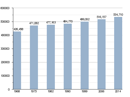
Doubs had a population, in 2014, of 534,710, for a population density of 102.2 inhabitants/km2. The arrondissement of Besançon, with 248,199 inhabitants, is the arrondissement with more inhabitants.
Evolution of the population in Doubs
The cities with more than inhabitants in the department are:
| City | Population (2014) |
Arrondissement |
|---|---|---|
| Besançon | 116,690 | Besançon |
| Montbéliard | 25,521 | Montbéliard |
| Pontarlier | 17,413 | Pontarlier |
| Audincourt | 14,131 | Montbéliard |
| Valentigney | 9,970 | Montbéliard |
| Morteau | 6,827 | Pontarlier |
| Seloncourt | 5,906 | Montbéliard |
| Bethoncourt | 5,729 | Montbéliard |
| Grand-Charmont | 5,535 | Montbéliard |
| Valdahon | 5,344 | Pontarlier |
Places of interest
Some places of interest are:
- The Citadel of Besançon.
- The Royal Saltworks at Arc-et-Senans.
- The castle of Montbéliard.
- The Fort de Joux.
- The village of Lods.
Gallery
-
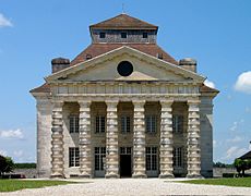
Royal Saltworks at Arc-et-Senans.
-
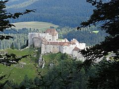
Fort de Joux.
-
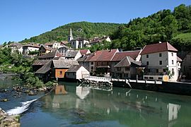
Lods, one of the most beautiful villages of France.
-
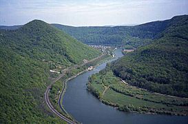
The Doubs river is the main river of the department.


.JPG)

Related pages
See also
 In Spanish: Doubs para niños
