
Echo Park facts for kids
Quick facts for kids
Echo Park
|
|
|---|---|

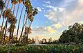
Echo Park Lake, with the Downtown Los Angeles skyline in the background
|
|

Echo Park
Location in Los Angeles

Echo Park
Location in the Los Angeles metropolitan area

Echo Park
Location in California

Echo Park
Location in the United States
|
|
| Country | |
| State | |
| County | Los Angeles |
| City | Los Angeles |
| Elevation | 120 m (394 ft) |
| Time zone | UTC−8 (PST) |
| • Summer (DST) | UTC−7 (PDT) |
| ZIP Code |
90026
|
| Area codes | 213, 323 |
Echo Park is a lively neighborhood in the middle of Los Angeles, California. It's located just northwest of Downtown. This area is known for its cool local shops and is a favorite spot for artists, musicians, and other creative people. The heart of the neighborhood is the beautiful Echo Park Lake.
Contents
History of Echo Park

Early Film Studios in Edendale
Long before Hollywood became famous for movies, a part of Echo Park called Edendale was a major center for filmmaking. This started way back in 1892.
By the 1910s, many film studios were busy along what is now Glendale Boulevard. Famous studios like Keystone Studios made movies here.
Many silent film stars worked in Edendale. These included Fatty Arbuckle, Harold Lloyd, Mabel Normand, and Gloria Swanson. Even Charlie Chaplin made his first film at Keystone Studios. The very first feature-length comedy also came from here.
A funny movie moment, the first "pie-in-the-face" scene, was filmed at what became the Mack Sennett Studios. This old studio building is now a historic landmark in Los Angeles.
The Story of Echo Park Lake
Echo Park Lake began as a drinking water reservoir in 1868. Water flowed into it from the Los Angeles River. In 1891, landowners gave the city 33 acres around the reservoir to create a park.
Work on the park started in 1892. The city's park superintendent named it "Echo Park" because he heard echoes during construction. By 1895, the park and a boathouse were complete. Movie companies even used the park for filming in the late 1910s.
In 2006, the lake was identified as needing a cleanup. The city spent $64.7 million to make it better. The lake closed in 2011 for a big renovation project. It reopened on June 5, 2013, looking beautiful after a $45 million update.
Transportation in Echo Park
Glendale Freeway
The Glendale Freeway (SR 2) was planned to connect to the Hollywood Freeway. However, it stops about 1.5 miles short of its goal. This happened because people living in the area didn't want the freeway built through their community.
This means that cars exiting the freeway now drive through Echo Park streets. This can cause traffic jams on roads like Glendale Boulevard. There have been ideas to turn the unused freeway part into a public park.
Pacific Electric Railway Red Cars
Long ago, the Pacific Electric Railway ran through Echo Park. These were electric trolleys, often called the "Red Cars." They traveled along Glendale Boulevard. At the start of the 1900s, this was the biggest and most advanced public transit system in the world. It connected many cities in Southern California.
The Red Car system eventually stopped running. The line through Echo Park officially ended service on June 19, 1955.
Geography and Climate
Echo Park has many hills and valleys. There are also some flat areas, like around Echo Park Lake. The main shopping and business streets are Sunset and Glendale boulevards.
.jpg)
Where is Echo Park?
Echo Park is in the central part of Los Angeles. It's located between Hollywood and Downtown Los Angeles. Major freeways like the 101, the 2, and the 5 are nearby.
Echo Park is surrounded by other neighborhoods. These include Elysian Valley to the north, Elysian Park to the east, and Silver Lake to the northwest.
Weather in Echo Park
Echo Park has a warm, sunny climate, much like the rest of Los Angeles. Summers are hot, and winters are mild. It doesn't rain very often, mostly in the cooler months.
| Climate data for Echo Park, Los Angeles | |||||||||||||
|---|---|---|---|---|---|---|---|---|---|---|---|---|---|
| Month | Jan | Feb | Mar | Apr | May | Jun | Jul | Aug | Sep | Oct | Nov | Dec | Year |
| Record high °F (°C) | 95 (35) |
95 (35) |
99 (37) |
106 (41) |
103 (39) |
112 (44) |
109 (43) |
106 (41) |
113 (45) |
108 (42) |
100 (38) |
92 (33) |
113 (45) |
| Mean maximum °F (°C) | 83.3 (28.5) |
84.3 (29.1) |
85.8 (29.9) |
91.2 (32.9) |
89.7 (32.1) |
90.2 (32.3) |
94.1 (34.5) |
95.3 (35.2) |
98.9 (37.2) |
95.5 (35.3) |
88.0 (31.1) |
81.4 (27.4) |
102.7 (39.3) |
| Mean daily maximum °F (°C) | 68.2 (20.1) |
68.6 (20.3) |
70.2 (21.2) |
72.7 (22.6) |
74.5 (23.6) |
78.1 (25.6) |
83.1 (28.4) |
84.4 (29.1) |
83.1 (28.4) |
78.5 (25.8) |
72.8 (22.7) |
67.7 (19.8) |
75.2 (24.0) |
| Daily mean °F (°C) | 58.0 (14.4) |
58.9 (14.9) |
60.6 (15.9) |
63.1 (17.3) |
65.8 (18.8) |
69.2 (20.7) |
73.3 (22.9) |
74.3 (23.5) |
73.1 (22.8) |
68.6 (20.3) |
62.4 (16.9) |
57.5 (14.2) |
65.4 (18.6) |
| Mean daily minimum °F (°C) | 47.8 (8.8) |
49.3 (9.6) |
51.0 (10.6) |
53.5 (11.9) |
57.1 (13.9) |
60.3 (15.7) |
63.6 (17.6) |
64.1 (17.8) |
63.1 (17.3) |
58.7 (14.8) |
52.0 (11.1) |
47.2 (8.4) |
55.6 (13.1) |
| Mean minimum °F (°C) | 41.3 (5.2) |
42.9 (6.1) |
44.9 (7.2) |
48.4 (9.1) |
53.6 (12.0) |
57.2 (14.0) |
61.2 (16.2) |
61.8 (16.6) |
59.2 (15.1) |
54.1 (12.3) |
45.0 (7.2) |
40.8 (4.9) |
39.1 (3.9) |
| Record low °F (°C) | 28 (−2) |
28 (−2) |
31 (−1) |
36 (2) |
40 (4) |
46 (8) |
49 (9) |
49 (9) |
44 (7) |
40 (4) |
34 (1) |
30 (−1) |
28 (−2) |
| Average rainfall inches (mm) | 3.12 (79) |
3.92 (100) |
2.43 (62) |
0.91 (23) |
0.26 (6.6) |
0.09 (2.3) |
0.01 (0.25) |
0.04 (1.0) |
0.24 (6.1) |
0.66 (17) |
1.04 (26) |
2.33 (59) |
15.05 (382.25) |
| Source: The Weather Channel | |||||||||||||
Neighborhood Areas
Echo Park has a few special areas within it:
Angelino Heights
Angelino Heights is famous for its beautiful old Victorian era houses. These homes are a reminder of how the area looked long ago.
Elysian Heights
Since the 1910s, Elysian Heights has been a home for many artists, writers, and filmmakers. It's a place where creative people have always gathered.
People of Echo Park
Echo Park is a very diverse neighborhood. Many different cultures and backgrounds make up the community. It's a place where people from all over the world live and work together.
Parks and Fun Places
Echo Park has many great spots for outdoor activities and relaxation.
Parks to Explore
Elysian Park
Elysian Park is one of Los Angeles's biggest and oldest parks. It was founded in 1886. A small part of this large park is in Echo Park.
- Angels Point: This is a small hill in Elysian Park. It offers amazing views of Dodger Stadium and the Downtown Los Angeles skyline.
- Chavez Ravine Arboretum: Opened in 1893, this arboretum has over 100 types of trees. Some of these trees are believed to be the oldest and largest of their kind in the United States.
- Grace E. Simons Lodge: This is a lovely event space with waterfalls and rooms for gatherings.
Echo Park Lake

Echo Park Lake is a wonderful place for fun and nature. It has wetlands that are home to many animals. The lake also hosts community events, like the annual Lotus Festival in July.
- Boathouse: You can rent swan-shaped paddle boats here and enjoy the water.
- Picnic Areas: There are picnic tables, BBQ pits, and grassy spots for family outings.
- Walking Trail: A 1-mile paved path goes around the lake, perfect for a walk or jog.
Vista Hermosa Natural Park
Vista Hermosa Natural Park is a 10.5-acre urban park. It has walking trails, streams, and meadows. You can also find oak trees and a nature-themed playground here. The park offers great views of the Downtown Los Angeles skyline.
Sports and Recreation Centers
- Chavez Ridge Disc Golf Course: Located in Elysian Park, this is a fun place to play disc golf.
- Echo Park Deep Pool: An indoor swimming pool for everyone to enjoy.
- Echo Park Recreation Complex: This complex has many features. It includes lighted baseball diamonds, basketball courts (indoor and outdoor), tennis courts, and a children's play area. A skate park opened here in 2020.
- Elysian Fields: Two baseball diamonds in Elysian Park.
Government and Services
Echo Park is part of the city of Los Angeles.
Local Services
The Los Angeles Fire Department has Station 20 in the area.
The Los Angeles Police Department (LAPD) has the Rampart Community Police Station nearby. They also have a police academy and training facility in Elysian Park.

Libraries for Learning

The Los Angeles Public Library has two branches in Echo Park: the Echo Park Branch and the Edendale Branch. These are great places to find books and learn new things.
Schools in Echo Park
Echo Park is part of the Los Angeles Unified School District. It has several schools for children to attend.
Public Schools
- Elysian Heights Elementary School
- Clifford Street Elementary School
- Mayberry Street Elementary School
- Gabriella Charter School
- Logan Street Span School
- Rosemont Elementary School
- Betty Plasencia Elementary School
Private Schools
- Baxter Montessori
- DC Academy
- Golden West Christian Preschool
Fun Things to Do
Food and Places to Eat
Echo Park is known for its cool restaurants and cafes. It's a popular spot for people looking for tasty food and a fun atmosphere. The historic Taix French restaurant has been a landmark since 1964. It's a favorite place for Los Angeles Dodgers fans before or after a game.
Interesting Places to Visit
- 3-D Space: This is a museum dedicated to 3-D technology and media. It's a unique place to learn about how 3-D works.
Famous People from Echo Park
Many interesting people have lived in or are connected to Echo Park.
- Veronica Porché Ali, a psychologist
- Carlos Almaraz, an artist
- Austin Amelio, an actor
- Tom Bradley, a former mayor of Los Angeles
- Jackson Browne, a musician
- Anna Camp, an actress
- Charlie Chaplin, a famous actor and filmmaker
- Frances Conroy, an actress
- Alice Cooper, a musician
- Lana Del Rey, a musician
- Mac DeMarco, a musician
- Leonardo DiCaprio, a well-known actor
- Glenn Frey, a musician
- Eric Garcetti, a former Los Angeles mayor
- Seth Green, an actor
- John Huston, a film director
- Art Ingels, who invented the Go-Kart
- Sasha Lane, an actress and model
- Shia LaBeouf, an actor
- Henry Jay Lewis, a musical conductor
- Aimee Semple McPherson, a famous evangelist
- Steve McQueen, an actor
- Alessandro Nivola, an actor
- Molly Parker, an actress
- Ariel Pink, a musician
- Leo Politi, an artist and illustrator
- Sara Ramirez, an actress
- Ann Robinson, an actress
- Horatio Sanz, a comedian and actor
- Mack Sennett, a film producer and director
- Peter Shire, an artist
- Sia, a musician and writer
- Elliott Smith, a musician
- Danny Trejo, an actor
- Valentina, a drag queen
- Eric Wareheim, an actor and comedian
- Clara Kimball Young, a silent film actress
- Frank Zappa, a musician and songwriter
Images for kids
-
Echo Park Lake, with the Downtown Los Angeles skyline in the background
See also
 In Spanish: Echo Park (Los Ángeles) para niños
