Englewood, Chicago facts for kids
Quick facts for kids
Englewood
|
|
|---|---|
| Community Area 68 – Englewood | |

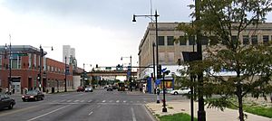
The intersection of 63rd and Halsted, looking south.
|
|

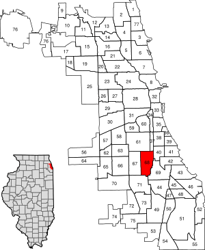
Location within the city of Chicago
|
|
| Country | United States |
| State | Illinois |
| County | Cook |
| City | Chicago |
| Neighborhoods |
list
Englewood
Hamilton Park |
| Area | |
| • Total | 3.09 sq mi (8.00 km2) |
| Population
(2020)
|
|
| • Total | 24,369 |
| • Density | 7,889/sq mi (3,046.1/km2) |
| Demographics 2020 | |
| • White | 1.2% |
| • Black | 92.1% |
| • Hispanic | 3.9% |
| • Asian | 0.6% |
| • Other | 2.2% |
| Time zone | UTC-6 (CST) |
| • Summer (DST) | UTC-5 (CDT) |
| Zip codes |
part of 60621
|
| Area code(s) | 773 |
| Median income 2020 | $22,228 |
| Source: U.S. Census, Record Information Services | |
Englewood is a neighborhood and community area located on the South Side of Chicago, Illinois, United States. It is the 68th of the 77 community areas in the city. In 1960, over 97,000 people lived here. However, the population has changed over time. In 2020, about 24,000 people called Englewood home.
Englewood covers about 3 square miles (8 square kilometers). It is bordered by Garfield Boulevard to the north and 75th Street to the south. Racine Avenue is its western border. The eastern border follows the Metra Railroad Tracks. West Englewood is a nearby area often grouped with Englewood.
Contents
Englewood's History
Early Days and Growth
Before 1850, Englewood was mostly an oak forest with many swampy areas. In 1852, several railroad lines met at a spot called Junction Grove. This meeting point helped the area grow into what we know as Englewood today. The Union Stock Yard provided many jobs for the first people who lived here.
In 1868, Henry B. Lewis, a wool merchant, suggested the name "Englewood." He was inspired by Englewood, New Jersey. Junction Grove became part of the Town of Lake in 1865. Later, in 1889, it joined the city of Chicago. The World's Columbian Exposition in 1893, held nearby at Jackson Park, helped the community expand even more.
The Englewood Shopping Center
The Englewood Shopping Center at 63rd & Halsted was a very important part of the community. It was a large area for walking and shopping. City services, social groups, and mall managers worked with community leaders. They helped make the mall a central place for everyone.
The shopping center hosted many community events. These included parades, outdoor concerts, and live radio shows. The Englewood Business Men's Association, led by Richard Drew, helped make this happen. After Mr. Drew passed away in 1978, the center lost its main stores, like Sears Roebuck. It then became a place for smaller shops.
Modern Revitalization Efforts
In 1999, Mayor Richard M. Daley announced a big plan to improve the area. This plan was worth $256 million. A key part of the plan was moving Kennedy–King College to the old shopping center site. The city then worked to buy out and move the mall's merchants.
The new college campus includes the Washburne Culinary Institute. Construction on the 40-acre (16-hectare) campus began on November 9, 2005. It officially opened in 2007. You can find digital pictures of Englewood in Explore Chicago Collections. This is a digital library from Chicago's archives and cultural places.
Community Parade
Englewood holds a community parade every year. This event helps prepare young people for the new school year. The Englewood Back To School Parade happens every third Saturday in August. Willie Pittman started the parade in 1961. He was also the first Black plumber licensed in Chicago. His plumbing business, Pittman Plumbing, still exists today.
Englewood's Population Changes
| Historical population | |||
|---|---|---|---|
| Census | Pop. | %± | |
| 1930 | 89,063 | — | |
| 1940 | 92,849 | 4.3% | |
| 1950 | 94,134 | 1.4% | |
| 1960 | 97,595 | 3.7% | |
| 1970 | 89,659 | −8.1% | |
| 1980 | 59,075 | −34.1% | |
| 1990 | 48,434 | −18.0% | |
| 2000 | 40,222 | −17.0% | |
| 2010 | 30,654 | −23.8% | |
| 2020 | 24,369 | −20.5% | |
In 2000, about 44% of households in Englewood faced economic challenges. This was higher than Chicago's overall rate of 20%. From 2008 to 2012, city data showed that about 46.6% of households were below the poverty line. Also, about 28% of people aged 16 and older were unemployed.
In 1960, Englewood had 67,216 African American residents. They made up about 69% of the population. Most African Americans lived around 63rd Street at that time. The average income in Englewood was about $5,579 in 1960.
By 1980, the total population was 62,069. This was a drop of about 30,000 people in twenty years. At this time, 99% of the people living in Englewood were Black. The number of white residents had decreased to 818. These population changes show how communities can shift over time.
Getting Around Englewood
Halsted Street is a main road in the neighborhood.
Public Transportation
Englewood has good public transportation options.
- The Red Line train stops at Garfield and 63rd stations.
- The Green Line train stops at Halsted station.
- The Dan Ryan Expressway (I-90 and I-94) also runs through Englewood.
Railroad Improvements
A railroad junction in Englewood used to cause delays. This is where the Metra (formerly Rock Island) tracks crossed the Norfolk Southern (formerly Pennsylvania Railroad) tracks. In March 2010, a $133 million project was announced. This project improved the train operations. It replaced the crossing with an overpass for Metra trains. The project was completed in 2014.
Learning in Englewood
Englewood has many public schools. Chicago Public Schools operates the primary and secondary schools. For higher education, the community has Kennedy–King College. This college moved to Englewood in 2005 to help with the neighborhood's revitalization. A public high school, Englewood STEM High School, opened in September 2019. It serves students in the surrounding area.
Englewood in Popular Culture
In 2018, Australian film director George Gittoes made a documentary about Englewood. The 2019 TV show South Side also takes place in the Englewood area.
Famous People from Englewood
Many well-known people have connections to Englewood:
- Jamie Foster Brown, a magazine publisher, and her sister Stella Foster, both entertainment journalists.
- Margaret Bonds, a composer, pianist, and educator.
- Young Chop, a music producer.
- Derrick Rose, a professional basketball player who played for the Chicago Bulls and currently plays for the Memphis Grizzlies.
- Anthony Davis, a professional basketball player for the Los Angeles Lakers and former player for the New Orleans Pelicans.
- Bina Deneen, First Lady of Illinois (1905–1913).
- Charles Deneen, 23rd Governor of Illinois (1905–1913) and later a United States Senator (1925–1931).
- Lil Durk, a rapper, singer, and songwriter who grew up in Englewood.
- Kenny Golladay, an NFL player.
- Jennifer Hudson, a famous singer and actress.
- Richard Hunt, a sculptor.
- Harold L. Ickes, 32nd United States Secretary of the Interior (1933–1946). He moved to Englewood as a child.
- Chief Keef, a rapper and record producer.
- Ralph Lewis, an actor known for The Birth of a Nation.
- Willard Motley, an African-American author.
- Bernie Mac, an actor and comedian who grew up in Englewood.
- James Meeks (born 1956), a pastor and former member of the Illinois Senate (2003–2013).
- William T. Murphy (1899–1978), a member of Congress from Illinois.
- Morgan F. Murphy, a member of Congress from Illinois.
- Lil Reese, a rapper.
- Fredo Santana, a rapper.
- Mavis Staples, a singer.
- Famous Dex, a rapper.
- King Von, a rapper.

