Gaviota Coast facts for kids
Quick facts for kids Gaviota Coast |
|
|---|---|
| Location | Santa Barbara County, California |
| Coordinates | 34°28′15″N 120°13′29″W / 34.47083°N 120.22472°W |
| Offshore water bodies | Pacific Ocean |
| Elevation | 23 feet (7 m) |
| Length | 76 miles (122 km) |
| Area | 200,000 hectares (490,000 acres) |
| Geology | Region |
| GNIS feature ID | 1702035 |
| ZIP codes | 93117, 93436 |
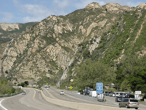
The Gaviota Coast is a special, mostly undeveloped coastline in Santa Barbara County, California. It stretches along the Santa Barbara Channel from Goleta Point in the south to the northern edge of the county. This unique part of Southern California features amazing cliffs, quiet beaches, and grassy hillsides.
Contents
History of the Gaviota Coast
Early Inhabitants and Spanish Arrival
People have lived along the Gaviota Coast for a very long time. Scientists have found signs of early people, called Paleo-Indians, from about 13,000 to 8,500 years ago. They lived near river mouths and the ocean, where food was plentiful.
Many villages of the Chumash people, who are Native Americans, were located here. Some of these villages included Qasil, Tajiguas, and Shishuchi'i'.
In 1769, the Spanish began to explore and settle Alta California. Much of the Gaviota Coast became part of large land grants, known as ranchos. These included Rancho Nuestra Señora del Refugio (1794), Rancho Punta de la Concepcion (1837), Rancho Cañada del Corral (1841), and Rancho Dos Pueblos (1842).
Oil, War, and State Parks
In the late 1920s, oil was discovered at the Ellwood Oil Field, leading to more drilling along the coast. During World War II, something surprising happened. On February 23, 1942, a Japanese submarine attacked the oil pier at Ellwood. This was just a few weeks after the attack on Pearl Harbor. No one was hurt, but the incident caused fear and panic on the West Coast.
After the war, the military radar unit that had been set up was removed. The land was sold to the state, and popular beach resorts became Refugio State Beach and El Capitán State Beach. These beaches are still favorite spots for visitors today.
Protecting the Coastline
In 1999, the government looked into making the Gaviota Coast a National Seashore. This would have protected a 76-mile stretch of coastline. While the area had important natural and cultural sites, the plan didn't happen. This was mainly because many local people didn't want it, and buying all the land would have been very expensive.
In 2015, there was an Refugio oil spill near Refugio State Beach. A pipeline broke, leaking a large amount of crude oil into the ocean.
More recently, in 2021, a plan for the Chumash Heritage National Marine Sanctuary began. This proposed marine sanctuary would protect about 156 miles of coastline and 7,600 square miles of ocean. It would include important Chumash heritage sites and protect amazing underwater habitats like kelp forests. These areas are vital for many fish and endangered species.
The Alisal Fire
The Alisal Fire started on October 11, 2021. It burned over 16,970 acres and destroyed 12 homes. Strong winds pushed the fire quickly through the Los Padres National Forest. Firefighters faced tough conditions, including very dry plants and strong winds that prevented planes from dropping water.
The fire crossed Highway 101, closing it for more than three days. Train services were also stopped. State beaches like Gaviota, Refugio, and El Capitán were closed and used by firefighters. The fire also damaged parts of the Tajiguas Landfill. Firefighters worked hard to protect homes and important places like Rancho del Cielo, which was President Ronald Reagan's vacation home. The fire was fully put out on November 20. After the fire, crews worked to prevent mudslides and repair damaged areas. Volunteers also helped native plants grow back.
Geography of the Gaviota Coast
The Gaviota Coast is a narrow strip of land. It sits between the rugged coastline and the Santa Ynez Mountains. These mountains run parallel to the coast for its entire length. The Santa Ynez River flows just north of the mountains. Much of the mountain range is part of the Los Padres National Forest.
The Gaviota Creek watershed is the largest along this coast. It is very important for steelhead fish. Refugio Creek is another large stream. It flows through orchards and ranches before reaching the Pacific Ocean.
The Bacara Resort was built on a part of the coast near the city of Goleta in 2000. The campus of the University of California, Santa Barbara (UCSB) is at the southern end of the Gaviota Coast.
Natural Environment
Ocean Life and Biodiversity
The ocean waters off the Gaviota Coast are very special. They have a unique mix of ocean life, called biodiversity. This is because cold water from the north meets warm water from the south here.
About 19,000 Gray whales migrate through the Santa Barbara Channel each year. They sometimes come as close as 100 feet from the shore! The marine environment also has huge kelp forests and wetlands. These areas are like nurseries for many kinds of fish and important homes for threatened and endangered species.
Land Animals and Plants
The Gaviota Coast has a Mediterranean climate. This means it has an amazing variety of plants and animals, with an estimated 1,400 different species. The Santa Ynez Mountains are a natural path for wildlife to travel. Animals like mountain lions, black bears, badgers, golden eagles, and the rare California condor live here.
A study in 2023 showed that it's important to improve "wildlife corridors." These are safe paths for animals to move. Fixing culverts (tunnels under roads) can help larger animals like mule deer and mountain lions cross safely.
Resource Utilization and Protection
Land Use and Protected Areas
In 1982, the county created a plan to protect the natural beauty of the Gaviota Coast. The narrow coastal land is mostly used for recreation and cattle grazing. The area isn't very crowded, and much of the land is part of large ranches. These ranches grow crops like avocados and lemons.
There are several protected areas along Highway 101. These include three public beaches with campgrounds and hiking trails: Gaviota State Park, El Capitán State Beach, and Refugio State Beach. There are also private campgrounds. Off the coast, there are several marine protected areas. These include Point Conception State Marine Reserve, Naples State Marine Conservation Area, and Kashtayit State Marine Conservation Area.
Special Ranches and Conservation Efforts
Dos Pueblos is a 214-acre ranch that was once planned to be a town called Naples, but it was never built. The Dos Pueblos Institute now uses the ranch as an outdoor classroom. They teach about sustainable farming and provide a place for Chumash ceremonies.
The Cultured Abalone Farm on the ranch works with the Santa Barbara Museum of Natural History Sea Center. They are helping to restore the wild populations of the endangered White Abalone, which is a type of marine snail. They also teach about sustainable aquaculture (farming seafood) and conservation.
Some ranches, like Hollister Ranch, have beautiful beaches that are hard for the public to reach. Other ranches are luxury estates. For example, El Rancho Tajiguas is a 3,600-acre working ranch with two luxury homes. The 1,800-acre Las Varas Ranch was bought by Charlie Munger and given to the University of California, Santa Barbara in 2018.
Energy Production
The Gaviota Coast was one of the first places in California to produce oil and gas from offshore platforms. You can see the Hondo and Harmony oil rigs offshore from the highway or railroad. Local rules keep the oil processing facilities small. The oil and gas are processed on land and then sent to distant refineries.
The Strauss Wind Farm started producing power in 2023. It has 27 windmills on hills near the ocean. This is the first wind power complex on the California coast. It even has a system called IdentiFlight that can spot approaching birds like red-tailed hawks and temporarily stop the turbines to protect them.
Transportation

Both US 101 and the main coastal railroad line run along the top of the coastal cliffs. They cross streams using train trestles. A 21-mile section of US 101 is called a "scenic highway" by the state. While the highway turns inland at Gaviota State Park, the railroad line stays along the coast for a longer, 30-mile section. Much of this area is not open to the public.
A 2.5-mile section of the California Coastal Trail has been built within Gaviota State Park. This trail, and others being planned, follow old paths used by the Chumash people and during the Spanish Period.
 | Audre Lorde |
 | John Berry Meachum |
 | Ferdinand Lee Barnett |


