Geography of Nicaragua facts for kids
 |
|
| Continent | North America |
|---|---|
| Region | Central America |
| Coordinates | 13°00′N 85°00′W / 13.000°N 85.000°W |
| Area | Ranked 96th |
| • Total | 130,370 km2 (50,340 sq mi) |
| • Land | 92.04% |
| • Water | 7.96% |
| Coastline | 910 km (570 mi) |
| Borders | Total border: 1,231 km (765 mi) |
| Highest point | Mogotón 2,085 metres (6,841 ft) |
| Lowest point | Pacific Ocean 0 metres (0 ft) |
| Longest river | Coco River 750 km (470 mi) |
| Largest lake | Lake Nicaragua 8,264 km2 (3,191 sq mi) |
| Exclusive economic zone | 123,881 km2 (47,831 sq mi) |
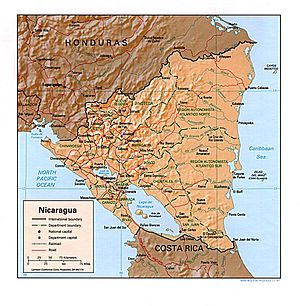
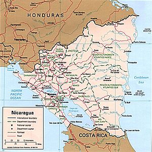
Nicaragua is a country located in Central America. It is officially known as the Republic of Nicaragua. This country touches both the Caribbean Sea on one side and the North Pacific Ocean on the other. It is found between Costa Rica to the south and Honduras to the north. Nicaragua is the biggest country in Central America when you look at its total area.
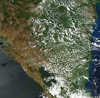
Nicaragua covers about 130,370 square kilometers. Most of this (119,990 square kilometers) is land. The country has many different climates and types of land. Its geography can be split into three main parts: the Pacific lowlands, the cooler central highlands, and the Caribbean lowlands.
Contents
Natural Regions of Nicaragua
Nicaragua has three main natural areas. These are the Pacific lowlands, the central highlands, and the Caribbean lowlands.
Pacific Lowlands: Volcanoes and Lakes
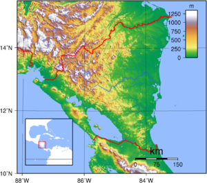
The Pacific lowlands stretch about 75 kilometers from the Pacific coast into the country. This area is mostly flat. However, there is a line of young volcanoes. Many of these volcanoes are still active. They run between the Golfo de Fonseca and Lago de Nicaragua. These peaks are just west of a large crack in the Earth's crust. This crack forms a long, narrow dip that goes southeast across the land from the Golfo de Fonseca to the Río San Juan.
Two of Central America's largest freshwater lakes are in this dip. These are Lago de Managua (56 kilometers long and 24 kilometers wide) and Lago de Nicaragua (about 160 kilometers long and 75 kilometers wide). The Río Tipitapa connects these two lakes. It flows south into Lago de Nicaragua. Lago de Nicaragua then drains into the Río San Juan. This river forms the border between Nicaragua and Costa Rica. It flows through the southern part of the lowlands to the Caribbean Sea.
The valley of the Río San Juan creates a natural path close to sea level. This path goes across Nicaragua from the Caribbean Sea to Lago de Nicaragua and the rift. From the southwest edge of Lago de Nicaragua, it's only 19 kilometers to the Pacific Ocean. This route was once thought of as a possible way to build a canal, like the Panama Canal.
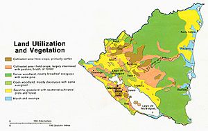
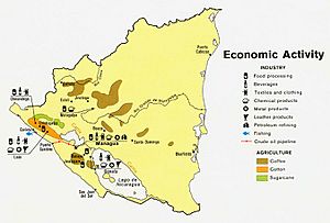
Around the lakes and extending northwest along the rift valley are very fertile plains. These plains are rich with volcanic ash from nearby volcanoes. Many people live in these lowlands, and a lot of farming happens here. The natural plants in the Pacific lowlands are dry forest. But much of this land is now used for farming or raising animals. West of the lake region, there is a narrow line of ash-covered hills and volcanoes. These separate the lakes from the Pacific Ocean. This line is highest near the cities of León and Managua.
Western Nicaragua is located where two large tectonic plates meet. Because of this, it often has earthquakes and volcanic eruptions. Volcanoes can damage farms with fumes and ash. But earthquakes have caused much more harm to people and buildings. Hundreds of small quakes happen every year. Some of them cause serious damage. The capital city of Managua was almost completely destroyed in 1931 and again in 1972.
Central Highlands: Mountains and Forests
The central highlands are a triangular area. They are found northeast and east of the Pacific lowlands. These are rugged mountains with ridges that are 900 to 1,800 meters high. They have a mix of oak and pine forests. Deep valleys are also found here. Most of the water from these valleys flows towards the Caribbean. Only a few small rivers flow west to the Pacific Ocean. These rivers are steep, short, and do not always flow.
The western parts of the central highlands are quite dry. The mountain ridges block the moist winds from the Caribbean. Because of this, farmers from the Pacific region have moved here since colonial times. The eastern parts of the highlands are covered with mountain rain forests. Not many people live here, mostly pioneer farmers and small groups of native people.
Caribbean Lowlands: Hot, Humid, and Vast
The eastern Caribbean lowlands of Nicaragua are a huge area. They make up more than half of the country's land. This area is known as the Costa de Mosquitos, or Miskito Coast. These lowlands are hot and humid. They include coastal plains, the eastern edges of the central highlands, and the lower part of the Río San Juan basin. The soil here is generally not very fertile. Pine and palm savannas grow along the Caribbean coast. They reach as far south as the Laguna de Perlas. There are also large areas of tropical rain forest. These include the Isthmian–Atlantic moist forests that go south from Laguna de Perlas past the Río San Juan into Costa Rica. The Central American Atlantic moist forests are found between the savannas and the central highlands. They also grow along rivers that flow through the savannas.
Fertile soils are only found along the natural banks and narrow floodplains of the many rivers. These rivers include the Escondido, the Río Grande de Matagalpa, the Prinzapolka, and the Coco. Many smaller streams also flow from the central highlands through this region. They end up in the shallow bays, lagoons, and salt marshes along the Caribbean coast.
Climate in Nicaragua
- Further information: Climate change in Nicaragua
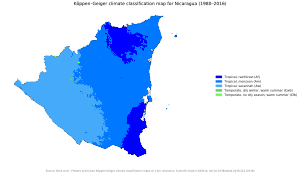
The temperature in Nicaragua does not change much with the seasons. It mostly depends on how high up the land is. The tierra caliente, or "hot land", is found in the foothills and lowlands. This is from sea level up to about 750 meters high. Here, daytime temperatures are usually around 30 to 33 degrees Celsius. At night, temperatures drop to about 21 to 24 degrees Celsius for most of the year.
The tierra templada, or "temperate land", is found in most of the central highlands. Here, the land is between 750 and 1600 meters high. Daytime temperatures are mild, around 24 to 27 degrees Celsius. Nights are cool, from 15 to 21 degrees Celsius.
Tierra fria, the "cold land", is found only on the highest peaks of the central highlands. These areas are above 1600 meters. Daytime temperatures here average 22 to 24 degrees Celsius. Nighttime temperatures can drop below 15 degrees Celsius.
Rainfall Patterns
Rainfall is very different across Nicaragua. The Caribbean lowlands are the wettest part of Central America. They get between 2500 and 6500 millimeters of rain each year. The western slopes of the central highlands and the Pacific lowlands get much less rain. This is because the central highlands block the moist winds from the Caribbean.
The rift valley and western slopes of the highlands get about 1000 to 1500 millimeters of rain each year. Rain is seasonal here. The rainy season is from May through October. The driest time is from December through April.
During the rainy season, eastern Nicaragua often has heavy floods. These happen along the upper and middle parts of all major rivers. Near the coast, rivers get wider, and their banks are low. Floodwaters spread out onto the floodplains. Large parts of the lowlands become covered in water. Farms along the river banks are often badly damaged. Many savanna animals can die during these floods.
The coast also gets strong tropical storms and hurricanes. These usually happen from July through October. The strong winds and floods from these storms often cause a lot of damage to homes and property. Also, heavy rains can come from the north. These are called papagayo storms. They can sweep through both eastern and western Nicaragua (especially the rift valley) from November through March.
Hurricanes or heavy rains in the central highlands can also damage crops. This is especially true where farming has removed much of the natural plants. This also causes soil erosion. In 1988, Hurricane Joan made hundreds of thousands of Nicaraguans leave their homes. It caused over US$1 billion in damage, mostly along the Caribbean coast. In November 2020, two big hurricanes, Eta and Iota, hit the country in almost the same places within weeks. They caused many deaths in the Caribbean region and millions of dollars in damage.
Climate Examples
| Climate data for Managua (extremes 1952-present) | |||||||||||||
|---|---|---|---|---|---|---|---|---|---|---|---|---|---|
| Month | Jan | Feb | Mar | Apr | May | Jun | Jul | Aug | Sep | Oct | Nov | Dec | Year |
| Record high °C (°F) | 37.0 (98.6) |
37.1 (98.8) |
37.8 (100.0) |
38.5 (101.3) |
38.5 (101.3) |
37.5 (99.5) |
39.2 (102.6) |
35.7 (96.3) |
36.5 (97.7) |
36.6 (97.9) |
35.4 (95.7) |
36.2 (97.2) |
39.2 (102.6) |
| Mean daily maximum °C (°F) | 31.0 (87.8) |
32.1 (89.8) |
33.6 (92.5) |
34.3 (93.7) |
34.0 (93.2) |
31.4 (88.5) |
30.9 (87.6) |
31.4 (88.5) |
30.3 (86.5) |
30.8 (87.4) |
30.6 (87.1) |
30.8 (87.4) |
31.8 (89.2) |
| Daily mean °C (°F) | 26.3 (79.3) |
27.2 (81.0) |
28.5 (83.3) |
29.3 (84.7) |
29.3 (84.7) |
27.2 (81.0) |
26.8 (80.2) |
27.2 (81.0) |
26.8 (80.2) |
26.5 (79.7) |
26.3 (79.3) |
26.2 (79.2) |
27.3 (81.1) |
| Mean daily minimum °C (°F) | 20.4 (68.7) |
20.6 (69.1) |
21.7 (71.1) |
22.6 (72.7) |
23.4 (74.1) |
23.0 (73.4) |
22.6 (72.7) |
22.4 (72.3) |
22.2 (72.0) |
22.1 (71.8) |
20.9 (69.6) |
20.0 (68.0) |
21.8 (71.2) |
| Record low °C (°F) | 15.0 (59.0) |
15.2 (59.4) |
17.2 (63.0) |
19.0 (66.2) |
16.0 (60.8) |
20.0 (68.0) |
20.0 (68.0) |
19.0 (66.2) |
15.0 (59.0) |
17.0 (62.6) |
15.0 (59.0) |
16.2 (61.2) |
15.0 (59.0) |
| Average rainfall mm (inches) | 9 (0.4) |
5 (0.2) |
3 (0.1) |
8 (0.3) |
130 (5.1) |
224 (8.8) |
144 (5.7) |
136 (5.4) |
215 (8.5) |
280 (11.0) |
42 (1.7) |
8 (0.3) |
1,204 (47.4) |
| Average rainy days (≥ 0.1 mm) | 4 | 2 | 2 | 2 | 10 | 22 | 20 | 17 | 20 | 19 | 10 | 5 | 133 |
| Average relative humidity (%) | 69 | 64 | 62 | 61 | 70 | 80 | 79 | 81 | 82 | 83 | 78 | 73 | 73 |
| Mean monthly sunshine hours | 263.5 | 254.2 | 291.4 | 276.0 | 229.4 | 186.0 | 151.9 | 195.3 | 210.0 | 223.2 | 231.0 | 248.0 | 2,759.9 |
| Mean daily sunshine hours | 8.5 | 9.0 | 9.4 | 9.2 | 7.4 | 6.2 | 4.9 | 6.3 | 7.0 | 7.2 | 7.7 | 8.0 | 7.6 |
| Source 1: Deutscher Wetterdienst | |||||||||||||
| Source 2: Meteo Climat (record highs and lows) | |||||||||||||
| Climate data for Bluefields | |||||||||||||
|---|---|---|---|---|---|---|---|---|---|---|---|---|---|
| Month | Jan | Feb | Mar | Apr | May | Jun | Jul | Aug | Sep | Oct | Nov | Dec | Year |
| Mean daily maximum °C (°F) | 27.8 (82.0) |
28.4 (83.1) |
29.0 (84.2) |
29.8 (85.6) |
29.9 (85.8) |
28.9 (84.0) |
28.1 (82.6) |
28.5 (83.3) |
29.1 (84.4) |
28.8 (83.8) |
28.4 (83.1) |
28.0 (82.4) |
28.7 (83.7) |
| Daily mean °C (°F) | 24.9 (76.8) |
25.2 (77.4) |
26.2 (79.2) |
27.0 (80.6) |
27.0 (80.6) |
26.0 (78.8) |
25.6 (78.1) |
25.6 (78.1) |
25.8 (78.4) |
25.6 (78.1) |
25.3 (77.5) |
25.2 (77.4) |
25.8 (78.4) |
| Mean daily minimum °C (°F) | 22.2 (72.0) |
22.3 (72.1) |
23.3 (73.9) |
23.7 (74.7) |
24.2 (75.6) |
23.9 (75.0) |
23.7 (74.7) |
23.6 (74.5) |
23.5 (74.3) |
23.1 (73.6) |
22.8 (73.0) |
22.6 (72.7) |
23.2 (73.8) |
| Average rainfall mm (inches) | 218 (8.6) |
114 (4.5) |
71 (2.8) |
101 (4.0) |
264 (10.4) |
581 (22.9) |
828 (32.6) |
638 (25.1) |
383 (15.1) |
418 (16.5) |
376 (14.8) |
328 (12.9) |
4,320 (170.2) |
| Average rainy days (≥ 1.0 mm) | 19 | 13 | 10 | 10 | 15 | 23 | 26 | 25 | 21 | 21 | 20 | 22 | 225 |
| Source: HKO | |||||||||||||
| Climate data for Puerto Cabezas | |||||||||||||
|---|---|---|---|---|---|---|---|---|---|---|---|---|---|
| Month | Jan | Feb | Mar | Apr | May | Jun | Jul | Aug | Sep | Oct | Nov | Dec | Year |
| Mean daily maximum °C (°F) | 29.7 (85.5) |
29.7 (85.5) |
30.5 (86.9) |
31.3 (88.3) |
31.8 (89.2) |
31.4 (88.5) |
30.8 (87.4) |
31.2 (88.2) |
31.2 (88.2) |
31.6 (88.9) |
30.8 (87.4) |
29.7 (85.5) |
30.8 (87.5) |
| Daily mean °C (°F) | 25.0 (77.0) |
24.5 (76.1) |
26.5 (79.7) |
27.2 (81.0) |
27.8 (82.0) |
27.5 (81.5) |
27.1 (80.8) |
27.1 (80.8) |
27.0 (80.6) |
26.3 (79.3) |
25.8 (78.4) |
25.4 (77.7) |
26.4 (79.6) |
| Mean daily minimum °C (°F) | 18.8 (65.8) |
18.6 (65.5) |
19.8 (67.6) |
20.9 (69.6) |
21.8 (71.2) |
22.0 (71.6) |
21.9 (71.4) |
22.0 (71.6) |
22.2 (72.0) |
21.6 (70.9) |
20.8 (69.4) |
19.3 (66.7) |
20.8 (69.4) |
| Average rainfall mm (inches) | 148 (5.8) |
83 (3.3) |
48 (1.9) |
54 (2.1) |
183 (7.2) |
378 (14.9) |
414 (16.3) |
370 (14.6) |
303 (11.9) |
338 (13.3) |
278 (10.9) |
202 (8.0) |
2,799 (110.2) |
| Average rainy days (≥ 1.0 mm) | 16 | 11 | 7 | 8 | 12 | 20 | 23 | 22 | 20 | 20 | 19 | 20 | 198 |
| Source: Hong Kong Observatory | |||||||||||||
Environment and Natural Challenges
Nicaragua often experiences natural events like earthquakes, volcanoes, and landslides. It also gets severe hurricanes sometimes. The country is currently working to fix problems like deforestation (losing forests), soil erosion, and water pollution. Nicaragua is part of important international agreements. These include the United Nations Framework Convention on Climate Change, the Climate Change-Kyoto Protocol, the Nuclear Test Ban, and the Ozone Layer Protection. It has also signed, but not yet fully approved, the Law of the Sea.
Extreme Points of Nicaragua
Here are the most extreme points of Nicaragua:
- Northernmost point: North of Liwa Sirpe
- Southernmost point: Trinidad, Río San Juan
- Westernmost point: Pacific coast at Gulf of Fonseca, Chinandega Department
- Easternmost point: Miskito Cays archipelago, North Caribbean Coast Autonomous Region
- Lowest point: Pacific Ocean (0 meters)
- Highest point: Mogotón (2,085 meters)
Maritime Claims
Nicaragua has specific claims over the waters near its coast:
- Contiguous zone: 24 nmi (about 44.4 km)
- Territorial sea: 12 nmi (about 22.2 km)
- Exclusive economic zone: 123,881 km2 (about 47,831 mi2)
See also
 In Spanish: Geografía de Nicaragua para niños
- List of ecoregions in Nicaragua
- List of islands of Nicaragua
- List of rivers of Nicaragua
- List of volcanoes in Nicaragua
- Protected areas of Nicaragua
- Territorial disputes of Nicaragua
- Water resources management in Nicaragua
 | Emma Amos |
 | Edward Mitchell Bannister |
 | Larry D. Alexander |
 | Ernie Barnes |


