Grand Calumet River facts for kids
Quick facts for kids Grand Calumet River |
|
|---|---|

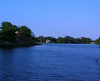
The Grand Calumet near its headwaters in Miller Beach, at the Middle Lagoon
|
|
| Country | United States |
| State | Indiana, Illinois |
| County | Lake County, Cook County |
| Physical characteristics | |
| Main source | Marquette Park (Gary) at the Miller Lagoons, Miller Beach, Indiana 581 ft (177 m) 41°37′04″N 87°15′34″W / 41.61778°N 87.25944°W |
| River mouth | Indiana Harbor and Ship Canal East Chicago, 10 miles from the headwaters, Lake County, Indiana 577 ft (176 m) |
| Length | 13.0 mi (20.9 km) |
The Grand Calumet River is a 13.0-mile-long (20.9 km) river. It mostly flows into Lake Michigan. The river starts in Miller Beach in Gary. It then goes through cities like Gary, East Chicago, and Hammond. It also flows through Calumet City and Burnham in Illinois.
Most of the river's water flows into Lake Michigan. This happens through the Indiana Harbor and Ship Canal. About 1,500 cubic feet (42 m3) of water goes into the lake every second. A smaller part of the river, at its western end, flows into the Calumet River. This water eventually reaches the Illinois River and then the Mississippi River.
Today, much of the river's water comes from city and factory wastewater. It also gets water from cooling systems and storm drains. Even though less pollution is released now, many harmful substances still affect the area. The Grand Calumet River is one of the most polluted rivers in the country. Around 2015, a big project was underway. It aimed to remove tons of polluted mud from the river bottom. This project helped to clean up the river's natural environment.
Contents
River's Path: East and West Branches
The Grand Calumet River is split into two main parts: an East Branch and a West Branch. These parts are on either side of the Indiana Harbor Canal.
East Branch: Flowing to Lake Michigan
The East Branch flows entirely into Lake Michigan. It begins in Marquette Park in Gary's Miller Beach area. It passes through three small lakes called lagoons. Then, it flows into the Miller Woods part of Indiana Dunes National Park. After that, it goes through Gary's industrial areas.
The East Branch leaves Gary by going under Cline Avenue. It then forms the border between East Chicago and Hammond. Finally, it reaches the Indiana Harbor Canal near Kennedy Avenue.
West Branch: Connecting to Other Rivers
The West Branch flows partly into the Indiana Harbor Canal. It also flows partly into the Calumet River. The Calumet River connects to the Chicago Area Waterway System. This system eventually leads to the Illinois River.
The point where the West Branch splits (some water to the Illinois River, some to Lake Michigan) is in Hammond, Indiana. This is close to the Illinois-Indiana state line. The West Branch joins the Little Calumet River in Burnham, Illinois. If you include the Indiana Harbor Canal, the river's total length is about 16.0 miles (25.7 km).
River History: How the Grand Calumet Changed
A long time ago, before factories grew in the Chicago area, the Grand Calumet River was different. It used to flow into Lake Michigan at Marquette Park in Miller Beach. This is near where the river starts today. Back then, the Grand Calumet included much of what is now called the Little Calumet River. The original "Little Calumet" was just a small stream. It drained into Lake Calumet. This older river was sometimes called Konomick or Kennomick. This name comes from the Miami language word kinwikami, meaning "long water river."
Things started to change in the early 1800s. Around 1805 or between 1809 and 1820, floods and human digging created a new path. This allowed the upper Grand Calumet (now the Little Calumet) to flow directly into Lake Calumet. This created the rivers as we know them today. What was once the upper Grand Calumet became part of the Little Calumet. At this time, the Grand Calumet still flowed from west to east. It emptied into Lake Michigan at Miller Beach.
In 1848, the Calumet Feeder Canal was built. It moved water from the Calumet system to the Illinois and Michigan Canal. This canal needed more water. This construction actually made the Grand Calumet flow in the opposite direction. It now flowed from east to west. By 1872, sandbars had completely blocked the river's original mouth at Miller Beach.
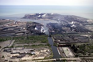
Factories began to appear along the Grand Calumet in the late 1800s. The George Hammond packing company in Hammond was one of the first. By 1885, too much industrial waste was building up in the river. In 1905, the Gary Works steel mill was built. This involved changing the path of a large part of the East Branch. This made room for the new steel mill. Before this, the Grand Calumet flowed across much of the land where the mill now stands. It could spread out to 1,000 feet wide during floods.
In 1906, the Indiana Harbor Canal was finished. This again changed the flow in the eastern part of the West Branch. This created the river's flow patterns we see today. The East Branch and the eastern part of the West Branch now empty into Lake Michigan at Indiana Harbor. The rest of the West Branch flows west.
More factories along the Grand Calumet led to more and more pollution. By the mid-1900s, the river was like an "industrial sewer." It could not support any life except for tiny algae and worms.
Pollution in the Grand Calumet River

About 90% of the water in the Grand Calumet River comes from factory and city wastewater. The part of the Grand Calumet in Indiana is known as a Great Lakes Areas of Concern (AoC). This means it's one of 43 places in the Great Lakes that need special attention because of pollution. The Grand Calumet has been on this list since 1986.
AoCs are named when they have problems with at least one of fourteen "beneficial uses." These are ways the river should be healthy for people and nature. The Grand Calumet is the only AoC that has problems with all fourteen beneficial uses.
These problems include:
- Rules about not eating fish from the river.
- Beaches being closed.
- Fish having tumors or strange shapes.
- Animals having deformities or problems having babies.
- Loss of places for fish and wildlife to live.
- Loss of tiny water creatures like benthos, phytoplankton, and zooplankton.
As of 2015, a big project was underway to clean the river. It was removing hundreds of thousands of tons of toxic mud from the bottom. This "dredging" project was expected to finish in 2016.
The biggest problem for the river comes from old pollution in the mud at the bottom. This pollution is from past factory activities. Today, the mud on the river bottom is "among the most polluted and toxic ever found." Only sludge worms can live in the Indiana Harbor and Ship Canal. This shows how bad the pollution is.
The Grand Calumet has harmful chemicals like PCBs (polychlorinated biphenyls) and PAHs (polynuclear aromatic hydrocarbons). It also has heavy metals like mercury, cadmium, chromium, and lead. Other issues include high levels of bacteria, oil, grease, and other waste. These pollutants come from many different places.
Sources of Pollution: Where it Comes From
Pollution in the Grand Calumet comes from two main types of sources: nonpoint sources and point sources.
Nonpoint Sources: Widespread Pollution
Nonpoint sources are pollution that comes from many different places. It's often carried by rain or groundwater.
- Polluted Mud: The river and canal have millions of cubic yards of polluted mud. This mud can be up to 20 feet deep. It contains toxic chemicals and other pollutants.
- Factory Waste Runoff: Rainwater and liquid waste from 11 old waste sites near the river are polluting the water. These sites are within 0.2 miles (300 m) of the river. The pollution includes oil, heavy metals, and other harmful chemicals.
- Superfund Sites: There are 52 "Superfund" sites in the area. These are places with very serious pollution that the government is trying to clean up. Five of these sites are on a special list for the most dangerous places.
- Hazardous Waste Sites: There are 423 hazardous waste sites in the area. These are places where dangerous waste is stored or thrown away.
- Underground Storage Tanks (USTs): More than 460 underground tanks are in the area. Over 150 reports of leaking tanks have been made in Lake County since 1987.
- Air Pollution: Harmful substances from burning fossil fuels, burning trash, and evaporation fall from the air. They land directly on the water or are washed into the river by rain. These include dioxins, PCBs, and heavy metals.
- City Runoff: Rainwater flowing over city streets picks up grease, oil, and toxic chemicals. It then washes them into the river.
- Polluted Groundwater: Water underground can be polluted with chemicals, metals, and oil. This polluted groundwater then flows into the river. The U.S. Environmental Protection Agency thinks that at least 16.8 million US gallons (64,000 m3) of oil float on top of the groundwater under the area.
Point Sources: Direct Pollution
Point sources are pollution that comes from a specific, single place, like a pipe.
- Factory and City Wastewater: Three steel factories release 90 percent of the direct industrial pollution into the river. One chemical factory also releases waste. These releases include harmful substances like arsenic, cadmium, cyanide, copper, chromium, lead, and mercury. Three city wastewater treatment plants (Gary, Hammond, and East Chicago) also release treated wastewater.
- Combined Sewer Overflows (CSOs): There are 15 CSOs that release untreated city waste into the river. This waste includes harmful chemicals. Each year, these CSOs release about 11 billion US gallons (42,000,000 m3) of raw wastewater. About 57% of this waste is released close to Lake Michigan. This causes bacteria pollution near the shore.
River Environment: Plants and Animals
The total area drained by the Grand Calumet River is small, less than 50 square miles. It is one of the smallest river areas in the region.
Fish and Wildlife: Life in the River
Most fish populations in the Grand Calumet were almost completely wiped out in the 1900s. However, the area where the river starts still has sensitive native fish species. One example is the Iowa darter. Today, most of the fish in the river are non-native species that eat decaying matter.
There are several nature preserves along the lower East Branch of the river. These are in Gary, East Chicago, and Hammond. They are managed by groups like The Nature Conservancy. These preserves are known as the Tolleston Strand Plain. They have a special habitat called "dune and swale." This type of habitat used to cover large areas around the Great Lakes. Now, it is very rare worldwide. Dune and swale areas are known for having many different kinds of plants and animals.
Rare and endangered species found in these nature preserves along the Grand Calumet include:
- The Karner blue butterfly.
- The Franklin's ground squirrel.
- The Blanding's turtle.
- The glass lizard.
- The black-crowned night heron.
 | Jackie Robinson |
 | Jack Johnson |
 | Althea Gibson |
 | Arthur Ashe |
 | Muhammad Ali |


