Greene County, Indiana facts for kids
Quick facts for kids
Greene County
|
|
|---|---|

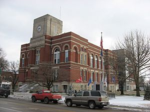
Greene County Courthouse in Bloomfield
|
|

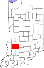
Location within the U.S. state of Indiana
|
|
 Indiana's location within the U.S. |
|
| Country | |
| State | |
| Founded | January 5, 1821 |
| Named for | Nathanael Greene |
| Seat | Bloomfield |
| Largest city | Linton |
| Area | |
| • Total | 545.92 sq mi (1,413.9 km2) |
| • Land | 542.50 sq mi (1,405.1 km2) |
| • Water | 3.42 sq mi (8.9 km2) 0.63%% |
| Population
(2020)
|
|
| • Total | 30,803 |
| • Density | 56.4240/sq mi (21.7854/km2) |
| Time zone | UTC−5 (Eastern) |
| • Summer (DST) | UTC−4 (EDT) |
| Congressional district | 8th |
| Indiana county number 28 | |
Greene County is a county located in the state of Indiana in the United States. In 2020, about 30,803 people lived here. The main town where the county government is located is Bloomfield. Did you know that in 1930, the U.S. Census Bureau said that the very middle point of the entire U.S. population was in Greene County?
Contents
History of Greene County
Greene County was officially created in 1821. It was formed from land that wasn't part of any county yet, and also from a piece of Sullivan County.
The county was named after a very important person: General Nathanael Greene. He was a general during the American Revolutionary War. He led the American army in the southern part of the country. His actions helped force the British army, led by General Charles Cornwallis, to retreat. This retreat eventually led to the British surrender at Yorktown, which helped America win its independence.
Climate and Weather in Greene County
| Weather chart for Bloomfield, Indiana | |||||||||||||||||||||||||||||||||||||||||||||||
|---|---|---|---|---|---|---|---|---|---|---|---|---|---|---|---|---|---|---|---|---|---|---|---|---|---|---|---|---|---|---|---|---|---|---|---|---|---|---|---|---|---|---|---|---|---|---|---|
| J | F | M | A | M | J | J | A | S | O | N | D | ||||||||||||||||||||||||||||||||||||
|
2.2
36
18
|
2.5
41
20
|
4.2
52
32
|
3.9
64
42
|
5
75
51
|
4.2
83
61
|
4.7
87
64
|
3.6
85
63
|
3.2
79
55
|
3.1
68
43
|
3.7
54
34
|
3.5
41
23
|
||||||||||||||||||||||||||||||||||||
| temperatures in °F precipitation totals in inches source: The Weather Channel |
|||||||||||||||||||||||||||||||||||||||||||||||
|
Metric conversion
|
|||||||||||||||||||||||||||||||||||||||||||||||
The weather in Bloomfield, Indiana, changes a lot throughout the year. In January, the average low temperature is around 18 °F (−8 °C). In July, the average high temperature reaches about 87 °F (31 °C).
However, temperatures can be much more extreme! The coldest temperature ever recorded in January was −21 °F (−29 °C) in 1963. The hottest temperature ever recorded was 106 °F (41 °C) in June 1953.
When it comes to rain and snow, May is usually the wettest month, with about 5.00 inches (127 mm) of precipitation. January is typically the driest, with around 2.20 inches (56 mm).
Education in Greene County
Greene County has five different school districts. These districts help make sure students get a good education.
- Bloomfield School District
- Eastern Greene County School District, which runs Eastern Greene High School
- Linton-Stockton School Corporation, which runs Linton-Stockton High School
- Shakamak Schools Metropolitan School District, which runs Shakamak Junior-Senior High School
- White River Valley School District, which runs White River Valley High School
Geography of Greene County
Greene County covers a total area of about 545.92 square miles (1,413.9 km2) (square miles). Most of this area, about 542.50 square miles (1,405.1 km2), is land. The rest, about 3.42 square miles (8.9 km2), is water. This means that 99.37% of the county is land and 0.63% is water.
Counties Next to Greene County
Greene County shares its borders with several other counties:
- Clay County – to the north
- Owen County – to the north
- Monroe County – to the east
- Lawrence County – to the southeast
- Martin County – to the south
- Daviess County – to the south
- Knox County – to the southwest
- Sullivan County – to the west
Cities in Greene County
Greene County has two main cities:
Towns in Greene County
There are also several smaller towns in Greene County:
Special Places in Greene County
These are areas that are recognized for census purposes but are not officially incorporated cities or towns:
Other Small Communities
Greene County also has many other small, unincorporated communities:
- Beehunter
- Calvertville
- Cincinnati
- Doans
- Dresden
- Elliston
- Furnace
- Gilmour (partially)
- Hashtown
- Hendricksville
- Hobbieville
- Hoosier
- Island City
- Johnstown
- Koleen
- Lone Tree
- Marco
- McVille
- Midland
- Midland Junction
- Mineral City
- Newark
- Park
- Plummer
- Point Commerce
- Redcuff Corner
- Ridgeport
- Rincon
- Solsberry
- Sponsler
- Stalcup Corner
- Summit
- Tanner
- Tulip
- Vicksburg
- Victoria
- White Rose
Local Government Areas (Townships)
Greene County is divided into smaller areas called townships for local government.
- Beech Creek
- Cass
- Center
- Fairplay
- Grant
- Highland
- Jackson
- Jefferson
- Richland
- Smith
- Stafford
- Stockton
- Taylor
- Washington
- Wright
Main Roads in Greene County
Several important highways run through Greene County, making it easy to travel to and from the area:
 I-69
I-69 US 231
 SR 43
SR 43 SR 45
SR 45 SR 48
SR 48 SR 54
SR 54 SR 57
SR 57 SR 58
SR 58 SR 59
SR 59 SR 67
SR 67 SR 157
 SR 445
Economy and Jobs in Greene County
The Greene County Economic Development Corporation (GCEDC) works to help new businesses start up and existing businesses grow in Greene County. They help bring new job opportunities to the area. They also work with the Indiana Economic Development Corporation to offer special help to companies that want to open or expand in the county.
Greene County is known as a "Labor Surplus Area" and an "SBA HUB Zone." This means that businesses in the county might have an advantage when bidding on government contracts. They can also get help from federal and state programs.
If you're looking for a job, WorkOne Linton is a local office that helps people find work and screens potential employees for businesses. There are also training programs available. You can find these at the Greene County Community Learning Center, which also offers access to courses from different colleges and universities.
Population of Greene County
| Historical population | |||
|---|---|---|---|
| Census | Pop. | %± | |
| 1830 | 4,242 | — | |
| 1840 | 8,321 | 96.2% | |
| 1850 | 12,313 | 48.0% | |
| 1860 | 16,041 | 30.3% | |
| 1870 | 19,514 | 21.7% | |
| 1880 | 22,996 | 17.8% | |
| 1890 | 24,379 | 6.0% | |
| 1900 | 28,530 | 17.0% | |
| 1910 | 36,873 | 29.2% | |
| 1920 | 36,770 | −0.3% | |
| 1930 | 31,481 | −14.4% | |
| 1940 | 31,330 | −0.5% | |
| 1950 | 27,886 | −11.0% | |
| 1960 | 26,327 | −5.6% | |
| 1970 | 26,894 | 2.2% | |
| 1980 | 30,416 | 13.1% | |
| 1990 | 30,410 | 0.0% | |
| 2000 | 33,157 | 9.0% | |
| 2010 | 33,165 | 0.0% | |
| 2020 | 30,803 | −7.1% | |
| 2023 (est.) | 31,196 | −5.9% | |
| US Decennial Census 1790–1960 1900–1990 1990–2000 2010 |
|||
The population of Greene County changes over time. According to the 2010 United States Census, there were 33,165 people living in the county. There were 13,487 households, which are groups of people living together in one home.
Most people in Greene County are white (98.1%). There are also smaller groups of Asian, American Indian, and Black or African American people. About 1.0% of the population is of Hispanic or Latino background.
In 2010, the average household had 2.44 people. The average family had 2.92 people. The median age of people in the county was 41.1 years old.
2020 Census Update
By the 2020 United States Census, the total population of Greene County was 30,803 people.
| Race | Number of People | Percentage |
|---|---|---|
| White (not Hispanic) | 29,035 | 94.2% |
| Black or African American (not Hispanic) | 53 | 0.17% |
| Native American (not Hispanic) | 68 | 0.2% |
| Asian (not Hispanic) | 104 | 0.34% |
| Pacific Islander (not Hispanic) | 4 | 0.01% |
| Other/Mixed (not Hispanic) | 988 | 3.2% |
| Hispanic or Latino | 551 | 1.8% |
See also
 In Spanish: Condado de Greene (Indiana) para niños
 | Stephanie Wilson |
 | Charles Bolden |
 | Ronald McNair |
 | Frederick D. Gregory |

