Humboldt County, Nevada facts for kids
Quick facts for kids
Humboldt County
|
||
|---|---|---|
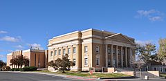
Humboldt County Courthouse in Winnemucca
|
||
|
||
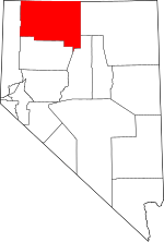
Location within the U.S. state of Nevada
|
||
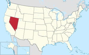 Nevada's location within the U.S. |
||
| Country | ||
| State | ||
| Founded | 1856 | |
| Named for | Humboldt River | |
| Seat | Winnemucca | |
| Largest city | Winnemucca | |
| Area | ||
| • Total | 9,658 sq mi (25,010 km2) | |
| • Land | 9,641 sq mi (24,970 km2) | |
| • Water | 17 sq mi (40 km2) 0.2% | |
| Population
(2020)
|
||
| • Total | 17,285 | |
| • Density | 1.78971/sq mi (0.69101/km2) | |
| Time zone | UTC−8 (Pacific) | |
| • Summer (DST) | UTC−7 (PDT) | |
| Congressional district | 2nd | |
Humboldt County is a large area of land in the state of Nevada, USA. It is called a county. In 2020, about 17,285 people lived there. Most of the county is countryside with very few people. The biggest city and main town is Winnemucca.
Humboldt County is an important place for travel. A major highway called Interstate 80 goes through it. This highway connects with US 95 in Winnemucca. This route is important for moving goods between Northern Nevada and places like Boise, Idaho and the Pacific Northwest. The first transcontinental railway, a train track that crosses the whole country, reached Humboldt County in 1868. Today, the Union Pacific Railroad still uses these tracks.
The county also has land that belongs to important Native American groups. These include the Fort McDermitt Paiute and Shoshone Tribe and the Winnemucca Indian Colony of Nevada.
Many people in Humboldt County work as ranchers and farmers. Recently, a new project called the Thacker Pass Lithium Mine has brought a lot of attention to the area. This mine would be the first big lithium mine in the United States. Lithium is a metal used in batteries for electric cars. The mine could help the local economy. However, some people are worried it might harm nature and important Native American sites.
Contents
History of Humboldt County
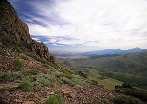
Humboldt County is the oldest county in Nevada. It was created in 1856. It was also one of the first nine counties when Nevada became a state in 1861. The county is named after the Humboldt River. This river was named by John C. Frémont after Alexander von Humboldt. He was a famous German scientist and traveler. Interestingly, Alexander von Humboldt never actually visited the places named after him.
The first main town of the county was Unionville in 1861. But when mining there slowed down, the county seat moved. In 1873, it moved to Winnemucca, which was on the new transcontinental railroad line.
Geography of Humboldt County
Humboldt County covers a huge area of about 9,658 square miles. Most of this is land, with only a small part being water. It is the fourth-largest county in Nevada by size.
The Santa Rosa Range is a mountain range that runs through the eastern part of Humboldt County. The highest point in the county is Granite Peak. It stands at 9,731 feet tall. Another important mountain is unofficially called Dan Dobbins Peak. It is in the remote Jackson Mountains.
Neighboring Counties
Humboldt County shares borders with several other counties:
- Harney County, Oregon - to the northwest
- Malheur County, Oregon - to the north
- Owyhee County, Idaho - to the northeast
- Elko County - to the east
- Lander County - to the southeast
- Pershing County - to the south
- Washoe County - to the west
Protected Natural Areas
Parts of Humboldt County are protected natural areas. These include:
- Black Rock Desert-High Rock Canyon Emigrant Trails National Conservation Area (part of it)
- Humboldt National Forest (part of it)
- Sheldon National Wildlife Refuge (part of it)
Native American Lands
The county includes land that belongs to Native American tribes. These are called Indian reservations.
Fort McDermitt Paiute and Shoshone Tribe
The Fort McDermitt Paiute and Shoshone Tribe has land in Humboldt County. This land is important to their culture and history.
Winnemucca Indian Colony of Nevada
The Winnemucca Indian Colony of Nevada also has land within Humboldt County. This land is home to members of the tribe.
People of Humboldt County
| Historical population | |||
|---|---|---|---|
| Census | Pop. | %± | |
| 1860 | 40 | — | |
| 1870 | 1,916 | 4,690.0% | |
| 1880 | 3,480 | 81.6% | |
| 1890 | 3,434 | −1.3% | |
| 1900 | 4,463 | 30.0% | |
| 1910 | 6,825 | 52.9% | |
| 1920 | 3,743 | −45.2% | |
| 1930 | 3,795 | 1.4% | |
| 1940 | 4,743 | 25.0% | |
| 1950 | 4,838 | 2.0% | |
| 1960 | 5,708 | 18.0% | |
| 1970 | 6,375 | 11.7% | |
| 1980 | 9,434 | 48.0% | |
| 1990 | 12,844 | 36.1% | |
| 2000 | 16,106 | 25.4% | |
| 2010 | 16,528 | 2.6% | |
| 2020 | 17,285 | 4.6% | |
| 2023 (est.) | 17,136 | 3.7% | |
| U.S. Decennial Census 1790-1960 1900-1990 1990-2000 2010-2018 |
|||
In 2010, there were about 16,528 people living in Humboldt County. Most people were white, but there were also many people of Hispanic or Latino origin. There were also American Indian, Asian, and African American people living there. About one-third of the homes had children under 18 living in them. The average age of people in the county was about 36 years old.
Education in Humboldt County
The Humboldt County School District is in charge of all the schools in the county. Students can attend high school programs at Albert M. Lowry High School and McDermitt Combined School.
For students who want to go to college, Great Basin College serves the area. Also, students living in Denio can choose to attend Crane Union High School, a boarding school in Oregon.
Economy of Humboldt County
Lithium Mine Project
Humboldt County is known for its ranching and farming. Recently, a big project called the Thacker Pass Lithium Mine has become very important. This mine aims to dig up lithium, which is a key material for making batteries for electric cars and other technologies.
The mine is expected to create many jobs and help the local economy. However, some people are concerned about its impact. They worry it might affect the environment and important cultural sites of Native American tribes in the area. This has led to discussions and debates about the mine's future.
Transportation in Humboldt County
Main Highways
 Interstate 80
 Interstate 80 Business Loop
 U.S. Route 95
 State Route 140
 State Route 289
 State Route 290
 State Route 292
 State Route 293
 State Route 294
 State Route 789
 State Route 794
 State Route 795
 State Route 796
Communities in Humboldt County
City
- Winnemucca (This is the main town, also called the county seat.)
Towns and Places
These are smaller towns and places where people live:
Other Small Communities
These are even smaller communities:
- Rebel Creek
- Stone House
- Tule
See also
 In Spanish: Condado de Humboldt (Nevada) para niños


