Inverkeithing facts for kids
Quick facts for kids Inverkeithing
|
|
|---|---|
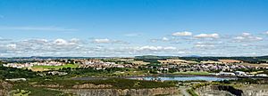 View of Inverkeithing |
|
| Population | 4,820 (2020) |
| OS grid reference | NT130829 |
| • Edinburgh | 9 mi (14 km) S |
| Council area | |
| Lieutenancy area | |
| Country | Scotland |
| Sovereign state | United Kingdom |
| Post town | Inverkeithing |
| Postcode district | KY11 |
| Dialling code | 01383 |
| Police | Fife |
| Fire | Fife |
| Ambulance | Scottish |
| EU Parliament | Scotland |
| UK Parliament |
|
| Scottish Parliament |
|
Inverkeithing (/ˌɪnvərˈkiːðɪŋ/ ; Scottish Gaelic: Inbhir Chèitinn) is a historic port town in Fife, Scotland. It sits on the Firth of Forth, a large sea inlet. Inverkeithing became a royal burgh in the 12th century. This special status gave it important trading rights.
In the Middle Ages, Inverkeithing was a busy trade centre. Later, in the 1800s, it became known for quarrying and ship breaking. This means taking apart old ships. In 2016, about 4,890 people lived in the town.
Today, Inverkeithing is a key transport hub. Its train station is a main stop on the Fife Circle Line. This line connects to Edinburgh. The town also has the Ferrytoll Park & Ride. This offers bus links across the Forth and to other parts of Fife. Inverkeithing is also on the Fife Coastal Path. This is one of Scotland's Great Trails for walking.
Contents
What Does the Name Inverkeithing Mean?
The name Inverkeithing comes from Scottish Gaelic. It is made of two parts: Inbhir and Céitein.
- Inbhir: This part means "confluence" or "inflow." It shows where a river meets a larger body of water. You can find it in many place names with Celtic roots.
- Céitein: This is the name of a small river or burn. It flows through the southern part of the town. Experts believe Céitein might come from an old word for "wood." So, the burn would have been a "stream that runs through woodland."
Where is Inverkeithing Located?
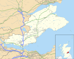
Inverkeithing is on the north coast of the Firth of Forth. It is about 16 kilometres (10 miles) from Edinburgh. It is also about 10 kilometres (6 miles) from Edinburgh Airport. The town is very close to Rosyth and Dalgety Bay. The city of Dunfermline is 6 kilometres (4 miles) northwest.
The town sits on a raised area that slopes towards Inverkeithing Bay. This bay cuts into the south of the town. The old town centre was along High Street and Church Street. Now, the town has grown to the north, east, and west. The Keithing Burn flows into the Inner Bay.
Inverkeithing is near the M90 motorway. This road connects Fife to Edinburgh. The town's train station is a hub for the Fife Circle Line. People travelling to Edinburgh cross the Forth Railway Bridge. The Ferrytoll Park & Ride helps people travel by bus. It connects to Edinburgh, Edinburgh Airport, and other parts of Fife.
The Fife Coastal Path goes through Inverkeithing. This walking path goes around the Inner Bay. It passes through the town and towards Dalgety Bay.
What is the Climate Like?
| Climate data for Inverkeithing (20 m asl, averages 1981–2010) | |||||||||||||
|---|---|---|---|---|---|---|---|---|---|---|---|---|---|
| Month | Jan | Feb | Mar | Apr | May | Jun | Jul | Aug | Sep | Oct | Nov | Dec | Year |
| Mean daily maximum °C (°F) | 7.0 (44.6) |
7.5 (45.5) |
9.5 (49.1) |
11.8 (53.2) |
14.7 (58.5) |
17.2 (63.0) |
19.1 (66.4) |
18.9 (66.0) |
16.5 (61.7) |
13.1 (55.6) |
9.6 (49.3) |
7.0 (44.6) |
12.7 (54.9) |
| Mean daily minimum °C (°F) | 1.4 (34.5) |
1.5 (34.7) |
2.8 (37.0) |
4.3 (39.7) |
6.8 (44.2) |
9.7 (49.5) |
11.5 (52.7) |
11.4 (52.5) |
9.4 (48.9) |
6.5 (43.7) |
3.7 (38.7) |
1.3 (34.3) |
5.9 (42.6) |
| Average rainfall mm (inches) | 67.5 (2.66) |
47.0 (1.85) |
51.7 (2.04) |
40.5 (1.59) |
48.9 (1.93) |
61.3 (2.41) |
65.0 (2.56) |
60.2 (2.37) |
63.7 (2.51) |
75.6 (2.98) |
62.1 (2.44) |
60.8 (2.39) |
704.2 (27.72) |
| Average rainy days (≥ 1 mm) | 12.5 | 9.4 | 9.9 | 8.8 | 9.6 | 9.6 | 9.5 | 9.7 | 10.2 | 12.4 | 11.2 | 11.4 | 124.2 |
| Mean monthly sunshine hours | 53.5 | 78.5 | 114.8 | 144.6 | 188.4 | 165.9 | 172.2 | 161.5 | 128.8 | 101.2 | 71.0 | 46.2 | 1,426.6 |
| Source: Met Office | |||||||||||||
A Look at Inverkeithing's History
Inverkeithing has a very long history. Some people think the Romans might have set up a camp here. This would have been around AD 78–87. Local stories say a holy man named St Erat founded a church here. This might have been in the 5th century.
The Medieval Period: A Royal Burgh is Born
Inverkeithing is first written about in 1114. It was mentioned in a document by King Alexander I. In 1163, it was called "Innirkeithin" in a church meeting document.
Around the 1160s, King Malcolm IV made Inverkeithing a royal burgh. This was one of the first in Fife. Being a royal burgh gave the town special legal and trading rights. Its location was perfect for this. It was at the narrowest point to cross the Firth of Forth. It also had a safe bay.
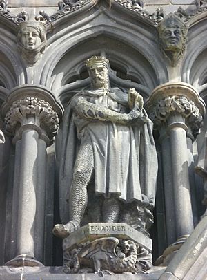
King Alexander III was last seen in Inverkeithing. This was before he died on March 19, 1286. He had crossed the Forth during a storm. He was going to visit Queen Yolande. A town official, Alexander Le Saucier, tried to get the King to stay. But Alexander left in the rain with two guides. He was found dead the next day. He had likely fallen from his horse.
Edward I of England visited Inverkeithing in 1304. He stayed there on his way back to Scotland. This was during the First War of Scottish Independence.
Inverkeithing was an important stop for pilgrims. These were religious travellers. They would stop here after crossing the Firth of Forth. They were often on their way to shrines in Dunfermline and St Andrews. A hostel for pilgrims was here as early as 1196. A Franciscan friary was also built in the mid-1300s. This was also for religious travellers. Today, Inverkeithing is part of the Fife Pilgrim Way.
The 16th and 17th Centuries: Changes and Challenges
Inverkeithing was one of the few Scottish towns with four stone gates. These were called "ports." Stone walls were added in 1557. The town had a successful trade in wool and animal hides. It was a busy place for markets and fairs.
However, trade began to slow down in the 1500s. The town became poorer. This continued into the 1600s. This was due to problems like plague and wars.
In the 1600s, Inverkeithing had many witch trials. Between 1621 and 1652, at least 51 people were executed. This was a very high number for a town of its size. This might have been due to disease outbreaks and a minister who was a known witch hunter. The executions happened at Witch Knowe. This area is now part of Hope Street Cemetery.
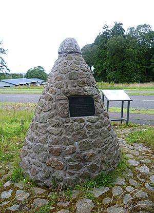
On July 20, 1651, the Battle of Inverkeithing took place. This was during Oliver Cromwell's invasion of Scotland. Cromwell's forces defeated the Scottish army. This battle was important. It led to Scotland coming under Cromwell's control. Many MacLean clansmen fought in the battle. A story says the Pinkerton Burn ran red with blood for three days.
The Modern Era: Industry and Growth
In the 1700s, Inverkeithing was described as "decayed." However, its industries became more varied. Lead and coal were mined. Coal was exported in large amounts. There was an iron foundry. By the late 1700s, the town had a brewery, leather works, and soap works. A whisky distillery opened in 1795.
In 1821, a new road called Preston Crescent was built. It had houses for retired sea captains. Preston Hill is also named after Sir Robert Preston. He put up a flagpole there to help ships.
By the mid-1800s, quarrying, engineering, and shipbuilding were big industries. The population grew quickly. Quarries provided stone for large projects. These included parts of the Forth Bridge. By 1870, engineering and shipbuilding had mostly stopped. The harbour lost trade to the railways.
The opening of the Forth Bridge in 1890 brought more people. By 1925, quarrying was still important. A papermaking industry also grew at the harbour. Caldwell's paper mill operated until 2003.
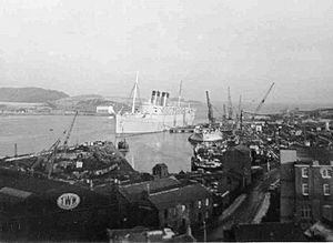
In the early 1900s, Inverkeithing became famous for shipbreaking. This happened at Thos. W. Ward's yard. Many famous ships were taken apart here. These included the battleship HMS Dreadnought and the Titanic's sister ship RMS Olympic. The second RMS Mauretania was also dismantled here. Today, the yard is a metal recycling facility.
Important Landmarks in Inverkeithing
Inverkeithing has several interesting old buildings and monuments.
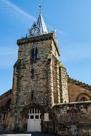
St. Peter's Church
St. Peter's Church is a B-listed building. It stands in a large churchyard. The church was first a wooden Celtic church. Then it became a Norman stone building. Its foundations were used for a 13th-century Gothic structure. A tower was added in the 1300s.
A fire in 1825 damaged the church. But the tower survived and the church was rebuilt. The main part of the church today is from 1826–27. The tower is the only part left from before the Scottish Reformation. It has a lead-covered spire from 1835.
Inside, the church has a beautiful medieval font from around 1398. This was found buried under the church. It was hidden during the Reformation. The font is decorated with angels holding shields. These include the royal arms of the King of Scots. They also show the arms of Queen Anabella Drummond. She was the wife of King Robert III. The high quality of the carving suggests it was a royal gift. Inverkeithing was a favourite place for Queen Anabella.
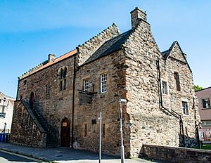
Hospitium of the Grey Friars
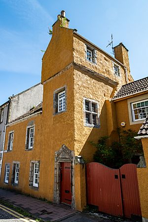
The Hospitium of the Grey Friars is a very old building. It is one of the best examples of a friary building in Scotland. A friary is a place where Franciscan monks lived. It might date back to the late 1200s.
The friary was a busy place for pilgrims. It had rooms for people to stay. It also had storage cellars and a chapel. In 1559, during the Scottish Reformation, the friary was sold. It was turned into a tenement (a type of apartment building). The hospitium building you see today was once the west end of the friary. It was the only part saved.
The building was repaired between 1932 and 1935. It now shows its 14th-century details. The building is mainly used as a community centre today.
Other Interesting Landmarks
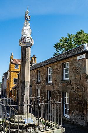
Inverkeithing has one of Scotland's best mercat crosses. A mercat cross was a symbol of a market town. This cross is believed to be a memorial. It marks the marriage of the Duke of Rothesay and the daughter of the Earl of Douglas.
The cross has moved several times. It is now at the junction of Bank Street and High Street. The main part of the cross is from the late 1300s. The octagonal shaft is from the 1500s. Two shields on the cross show the arms of Queen Anabella Drummond and the Douglas family. A unicorn and a St Andrew's Cross were added in 1688.
Thomsoun's House is on Bank Street. It dates from 1617. It was rebuilt in 1965. Its carved stone front has thistle shapes. It also has the initials of the first owners, John and Bessie Thomson.
Fordell's Lodging is across from St Peter's Church. This old house is from 1671. Rosebery House on King Street is also very old. It might be the oldest house still standing in the burgh. It has an unusual sloped roof.
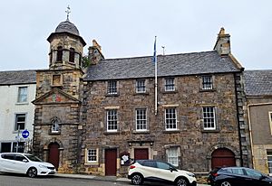
The Inverkeithing Town House is on Townhall Street. It is also known as the Tolbooth. It has the old town coat of arms above the front door. The tower is the oldest part, from 1755. The main building was built in 1770. It had a prison, a court room, and a debtors' prison.
How Inverkeithing is Governed
Inverkeithing is part of the Dunfermline and West Fife area for the UK Parliament. As of 2023, Douglas Chapman is the Member of Parliament (MP). He is from the Scottish National Party (SNP).
For the Scottish Parliament, Inverkeithing is part of the Cowdenbeath area. This area is within the Mid Scotland and Fife region. As of 2023, Annabelle Ewing represents this area. She is also from the SNP.
Culture and Education in Inverkeithing
Inverkeithing has a strong football history. Inverkeithing United played from 1906 to 1963. They won the Scottish Junior Cup in 1912–13. A new club, Inverkeithing Hillfield Swifts, was founded in 1996. They now play in the .
The Ballast Bank grounds host Inverkeithing's annual highland games. These games have been held since at least 1914. They attract thousands of spectators. In 2014, the Inverkeithing Highland Games were shown on the US TV show Duck Dynasty.
The town has two schools: Inverkeithing Primary School and Inverkeithing High School. Both are on Hillend Road. Inverkeithing High School serves students from nearby towns. This means it has over 1,500 students. The old primary school building was destroyed by a fire in 2018.
Famous People from Inverkeithing
Many notable people have connections to Inverkeithing:
- James Anderson: Manager of Mount Vernon, George Washington's estate. He helped Washington start a whisky distillery.
- Richard de Inverkeithing: A 13th-century church leader. He was a Chamberlain for King Alexander II. He also became the Bishop of Dunkeld.
- Gordon Durie: A former professional football player. He played for clubs like Glasgow Rangers and Chelsea. He also played for the Scotland national team. He studied at Inverkeithing High School.
- Samuel Greig: A Russian admiral. He is known as the "Father of the Russian Navy."
- Stephen Hendry: A famous professional snooker player. He is a multiple world champion. He went to Inverkeithing High School.
- Craig Levein: A former football player and Scotland manager. He also managed Heart of Midlothian. He studied at Inverkeithing High School.
- Robert Moffat: A missionary to Africa. He was the father-in-law of explorer David Livingstone. He lived in Inverkeithing in his early years.
- David Spence: He received the Victoria Cross. This was for his bravery during the Indian Rebellion of 1857.
See also
- Inverkeithing (Parliament of Scotland constituency)
- List of places in Fife
 | Charles R. Drew |
 | Benjamin Banneker |
 | Jane C. Wright |
 | Roger Arliner Young |


