
Kelleys Island, Ohio facts for kids
Quick facts for kids
Kelleys Island, Ohio
|
|
|---|---|
|
Village
|
|

Aerial photo of Kelleys Island, looking west
|
|
| Nickname(s):
Kelleys
|
|

Location of Kelleys Island, Ohio
|
|

Location of Kelleys Island in Erie County
|
|
| Country | United States |
| State | Ohio |
| County | Erie |
| Area | |
| • Total | 4.41 sq mi (11.41 km2) |
| • Land | 4.35 sq mi (11.26 km2) |
| • Water | 0.06 sq mi (0.15 km2) |
| Elevation | 614 ft (187 m) |
| Population
(2020)
|
|
| • Total | 256 |
| • Density | 58.88/sq mi (22.73/km2) |
| Time zone | UTC-5 (Eastern (EST)) |
| • Summer (DST) | UTC-4 (EDT) |
| ZIP code |
43438
|
| Area code(s) | 419 |
| FIPS code | 39-39662 |
| GNIS feature ID | 1086065 |
| Website | kelleysisland.us |
|
Kelleys Island South Shore District
Kelleys Island Historic District |
|
.jpg)
Kelleys Island Village Hall
|
|
| Location | Water St. on the southern side of Kelleys Island (original) Entire island (increase) |
|---|---|
| Area | 23 acres (9.3 ha) (original) 2,888 acres (1,169 ha) |
| Architectural style | Italianate, Queen Anne, Gothic Revival |
| NRHP reference No. | 75001380 (original); 88002734 (increase) |
| Added to NRHP | March 27, 1975 (original) December 15, 1988 |
Kelleys Island is a small village and island located in Lake Erie, Ohio. It's part of Erie County, Ohio. The island covers about 4.41 square miles and was shaped by glaciers moving over limestone and dolomite rock long ago.
As of 2020, about 289 people live on Kelleys Island all year. However, it's mostly a popular vacation spot, so many more people visit and work there during the summer months.
Contents
Kelleys Island: A Look at Its Past
Kelleys Island has a rich history, once home to Native American tribes and later becoming a busy center for mining and tourism.
Early Days and Native Americans
Before European settlers arrived, Kelleys Island was visited by Native American tribes like the Erie. They came to fish and sometimes lived on the island until around 1656.
During the War of 1812, the island was used by both British and U.S. soldiers. The British called it Sandusky Island. Later, the U.S. named it "Island Number 6" and "Cunningham Island." For a while, the island was mostly empty.
Inscription Rock: Ancient Art on Stone
On the south side of the island, there's a large limestone rock called 'Inscription Rock'. It has ancient carvings, called petroglyphs, made by early Native Americans. These carvings might have been used to share information about hunting or where groups were traveling.
The rock is quite big, about 32 feet long and 21 feet wide. Over time, many of the carvings have faded. Historians believe the carvings date back to around 1643.
How Kelleys Island Got Its Name
In the early 1800s, a few European settlers tried to live on the island, but it was still mostly wild. In 1830, two brothers, Datus and Irad Kelley, started buying land on the island. They were born in Connecticut and became successful in Ohio. Irad first saw the island when his boat had to take shelter there during a storm.
By 1840, the Kelley brothers owned almost the entire island. They renamed it Kelleys Island after themselves. At that time, about 68 people lived there.
Growth and Industry
The Kelley brothers quickly developed the island. They built docks to ship out limestone, fruit, and red cedar wood. Many kilns were built to produce lime from the limestone. Workers from different countries, including Ireland, Poland, and Italy, came to work in the quarries.
The quarries led to the creation of the Kelley Island Lime & Transport Company, which became one of the world's largest producers of limestone products. You can still see ruins of these old operations around the island today.
In 1842, people started growing grapes for wine on Kelleys Island. By the early 1900s, the island was making a huge amount of wine each year. The village grew, adding a library and post office. In 1901, the Estes Schoolhouse was built.
Kelleys Island Today
Today, Kelleys Island is still heavily forested, with some areas for homes and vacationers. A few small farms and a limestone quarry still operate. Every summer since 1974, the island hosts a weekend-long homecoming festival with a parade, picnic, and food stalls.
The island has a cemetery on Division Street, where many people, including Datus Kelley, are buried. In 1975, the island's southern shore was recognized as a historic district and added to the National Register of Historic Places. Later, in 1988, the entire island became part of this historic district.
Kelleys Island is also part of the Great Lakes Islands Alliance, a group of islands in the U.S. and Canada that work together.
Things to Do on Kelleys Island
Kelleys Island is a popular spot for vacations and outdoor activities. It's one of only 17 islands in the Great Lakes that has people living there all year.
Beaches and Nature
The island has several public beaches where you can go swimming, boating, and fishing.
Kelleys Island is also known for its unique natural areas. For example, it has an Alvar habitat, which is a rare type of grassland with thin soil over limestone. However, some reports have noted that the island's natural areas face challenges from development and tourism.

Glacial Grooves: A Window to the Ice Age
One of the most famous natural attractions is the Glacial Grooves State Memorial. Here, you can see huge grooves carved into the rock by glaciers during the Pleistocene (the last Ice Age). These grooves are about 9 meters (30 feet) wide and 4.5 meters (15 feet) deep, stretching for about 120 meters (400 feet). They show how powerful the ice was as it moved across the land.
Island Businesses
Most businesses on Kelleys Island are pubs and restaurants, which are open mainly from May to September. You can also find a coffee shop, a miniature golf course, small general stores, and many gift shops.
The Kelley's Island Wine Company, first started in 1872, was once one of the biggest wineries in the country. It closed after fires during the Prohibition era. In 1982, a family reopened The Kelley's Island Wine Company at an old stone cottage.
Camps on the Island

Kelleys Island is home to several camps:
- Kelleys Island State Park has a large campground.
- Camp Patmos, a Christian youth camp, is on the northeast side of the island. It was bought in 1952 to be a faith-based summer camp.
- The Erie County 4H Camp is located on the north side of the island.
Getting Around Kelleys Island
Kelleys Island is connected to the mainland by ferries and has a small airport.
Ferries
The first regular ferry service to the island was the Neuman Ferry, started in 1907. Today, the Kelleys Island Ferry is the only line that runs year-round (if the weather allows) between the island and Marblehead, Ohio. The ride takes about 25 minutes.
Another ferry, the Jet Express, runs during the tourist season from May to September. It carries only passengers (no vehicles) from Sandusky, Ohio, and Cedar Point to Kelleys Island. This trip also takes about 25 minutes from Sandusky.
Airport

On the east side of the island, there's a small public airport called the Kelleys Island Land Field Airport (FAA LID: 89D). It has one runway and parking for planes.
Highways and Other Transportation

Kelleys Island is served by Ohio State Route 575. This road was created in 1937 and is unique because it's not connected to the rest of Ohio's highway system.
Because the island is small, many people use bicycles, golf carts, and motor scooters to get around. You can bring cars to the island on the ferry. Most roads are modern, but some on the north side and near the old quarries are unpaved.
Island Geography and Geology

Kelleys Island has a total area of about 4.41 square miles, with 4.35 square miles of land and 0.06 square miles of water.
How the Island Was Formed
Kelleys Island is made of limestone and dolomite rocks that formed during the Middle Devonian period. These rocks were once soft muds and sediments at the bottom of an ancient sea. Over millions of years, they hardened into the rock we see today.
Later, during the Pleistocene Ice Age, huge glaciers moved across the island. These glaciers were incredibly powerful, carving out the deep glacial grooves and shaping the island's landscape. Scientists believe these grooves were formed by fast-moving meltwater under the ice.
Island Population Facts
The population of Kelleys Island has changed quite a bit over the years.
| Historical population | |||
|---|---|---|---|
| Census | Pop. | %± | |
| 1900 | 1,174 | — | |
| 1910 | 1,017 | −13.4% | |
| 1920 | 708 | −30.4% | |
| 1930 | 638 | −9.9% | |
| 1940 | 564 | −11.6% | |
| 1950 | 324 | −42.6% | |
| 1960 | 171 | −47.2% | |
| 1970 | 175 | 2.3% | |
| 1980 | 121 | −30.9% | |
| 1990 | 172 | 42.1% | |
| 2000 | 367 | 113.4% | |
| 2010 | 312 | −15.0% | |
| 2020 | 289 | −7.4% | |
| U.S. Decennial Census | |||
Recent Population Data
According to the 2020 census, Kelleys Island had a population of 289 people. The average age of residents was 65.9 years.
In the 2010 census, there were 312 people living on the island. Most residents were White (98.1%). The average age was 58.8 years.
Education on Kelleys Island
The Kelleys Island School serves the students on the island. The village also has a public library, which is part of the Sandusky Library system.
Images for kids
-
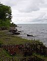
Alvar habitat on Kelleys Island. South Bass Island visible in distance.
-
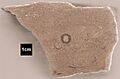
Etched section of hand sample of Columbus Limestone from quarry on Kelley's Island. Circular feature is cross section of a rugose coral.


See also
 In Spanish: Kelleys Island (Ohio) para niños
