
Lee, Massachusetts facts for kids
Quick facts for kids
Lee, Massachusetts
|
||
|---|---|---|

Town Hall
|
||
|
||
| Nickname(s):
Wildcats
|
||
| Motto(s):
"Gateway to the Berkshires"
|
||

Location in Berkshire County and Massachusetts.
|
||
| Country | United States | |
| State | Massachusetts | |
| County | Berkshire | |
| Settled | 1760 | |
| Incorporated | October 21, 1777 | |
| Government | ||
| • Type | Open Town Meeting | |
| Area | ||
| • Total | 27.0 sq mi (70.0 km2) | |
| • Land | 26.1 sq mi (67.7 km2) | |
| • Water | 0.9 sq mi (2.3 km2) | |
| Elevation | 1,000 ft (305 m) | |
| Population
(2020)
|
||
| • Total | 5,788 | |
| • Density | 214.16/sq mi (82.69/km2) | |
| Time zone | UTC-5 (Eastern) | |
| • Summer (DST) | UTC-4 (Eastern) | |
| ZIP code |
01238
|
|
| Area code(s) | 413 | |
| FIPS code | 25-34655 | |
| GNIS feature ID | 0618268 | |

Lee is a town located in Berkshire County, Massachusetts, in the United States. It is part of the Pittsfield, Massachusetts, metropolitan area. In 2020, about 5,788 people lived here. Lee includes the smaller villages of South and East Lee. It is a popular part of the Berkshires resort area.
Contents
History of Lee, Massachusetts
Early Settlement and Naming
Lee is built on land that once belonged to the Mahican Native American people. The first non-native settlement started around 1760. It was called Dodgetown, named after Asahel Dodge, who moved there from Cape Cod. Lee officially became a town in 1777. It was formed from parts of Great Barrington and Washington. The town was named after General Charles Lee, a leader in the American Revolutionary War. Lee was once a busy town with many factories, known as a "mill town."
Shays' Rebellion and Early Industries
In 1786, during Shays' Rebellion, about 250 followers of Daniel Shays met state troops near East Lee. The Shaysites tricked the troops with a fake cannon made from a yarn beam, and the troops ran away.
Early jobs in Lee included farming, cutting down trees for wood, and making lime. The many streams and rivers provided power for mills. These mills made things like cloth and wire.
Papermaking Industry
Papermaking became the main industry in Lee starting in 1806. The Willow Mill was built in South Lee by Samuel Church. Later, the Columbia Mill in central Lee opened in 1827. This mill was the first to provide 100% wood pulp newsprint to The New York Times. By 1857, Lee had 25 paper mills! The Smith Paper Company found a way to make paper only from wood pulp in 1867. Through the 1870s, it was the biggest paper producer in the country. Most of these paper mills closed in 2008. Today, Lee has only one papermaking factory left.
Famous Lee Marble
Lee is also famous for its high-quality marble. The first marble quarry opened in 1852. By 1867, a huge amount of marble was dug up and sent out by train. Many famous buildings use Lee marble. These include a part of the United States Capitol in Washington, D.C.. Also, 250 sculptures on Philadelphia City Hall, the General Grant National Memorial, and St. Patrick's Cathedral in New York City are made from Lee marble.
Historic Charm and Tourism
You can still see Lee's rich history in its old buildings. The town hall, library, churches, and many homes show its 19th-century success. South Lee has a special historic area listed on the National Register.
Today, Lee is a popular place for tourists. People love its New England charm and its cozy bed and breakfast places. It is called the "Gateway to The Berkshires" because it has one of the main exits from the Massachusetts Turnpike that leads into the area.
Lee in Pop Culture
The famous musician Arlo Guthrie had a court appearance in the Lee Town Hall. This event was part of his song "Alice's Restaurant." Lee was also a filming location for the movies Before and After (1996) and The Cider House Rules (1999).
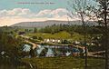
-
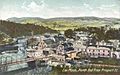
North End c. 1907
-
Columbia Mills c. 1912
-
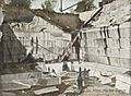
Marble quarry c. 1905


Geography and Location
Town Area and Borders
Lee covers about 70.0 square kilometers (27.0 square miles). About 67.7 square kilometers (26.1 square miles) is land, and 2.3 square kilometers (0.9 square miles) is water. Lee is bordered by several towns. These include Lenox to the northwest and Washington to the northeast. It is also near Becket, Tyringham, Great Barrington, and Stockbridge. Lee is about 16 kilometers (10 miles) south of Pittsfield.
Natural Features
Lee is in the southern part of the Berkshires. It sits in a valley along the Housatonic River. Part of October Mountain State Forest is in Lee. A section of Beartown State Forest is also in the town. Important water bodies include Laurel Lake to the north and Goose Pond to the southeast. The famous Appalachian Trail runs near the eastern part of town.

Transportation in Lee
Lee is located on Interstate 90, also known as the Massachusetts Turnpike. It has Exit 10, which is an important exit for the western part of the turnpike. U.S. Route 20, an older main road, also passes through Lee.
The town is on the Housatonic Railroad line. This train line connects to cities like Pittsfield and Great Barrington. There are talks about bringing back train service for people traveling between the Berkshires and New York City. Buses from the Berkshire Regional Transit Authority (BRTA) also serve Lee. You can find regional bus stops at the Town Hall. For air travel, the closest major airport is Albany International Airport in New York.
Climate
Lee has a humid continental climate. This means it has cold winters and warm summers.
| Climate data for Lee, Massachusetts (01238) | |||||||||||||
|---|---|---|---|---|---|---|---|---|---|---|---|---|---|
| Month | Jan | Feb | Mar | Apr | May | Jun | Jul | Aug | Sep | Oct | Nov | Dec | Year |
| Mean daily maximum °F (°C) | 29 (−2) |
32 (0) |
41 (5) |
54 (12) |
65 (18) |
73 (23) |
78 (26) |
76 (24) |
68 (20) |
56 (13) |
45 (7) |
34 (1) |
54 (12) |
| Mean daily minimum °F (°C) | 13 (−11) |
15 (−9) |
22 (−6) |
34 (1) |
45 (7) |
54 (12) |
59 (15) |
57 (14) |
50 (10) |
38 (3) |
30 (−1) |
20 (−7) |
36 (2) |
| Average precipitation inches (mm) | 3.91 (99) |
3.74 (95) |
4.31 (109) |
4.36 (111) |
4.50 (114) |
4.90 (124) |
4.75 (121) |
4.53 (115) |
4.36 (111) |
5.03 (128) |
4.50 (114) |
4.36 (111) |
53.25 (1,352) |
| Source: The Weather Channel | |||||||||||||
Population and People
| Historical population | ||
|---|---|---|
| Year | Pop. | ±% |
| 1850 | 3,220 | — |
| 1860 | 4,420 | +37.3% |
| 1870 | 3,866 | −12.5% |
| 1880 | 3,939 | +1.9% |
| 1890 | 3,785 | −3.9% |
| 1900 | 3,596 | −5.0% |
| 1910 | 4,106 | +14.2% |
| 1920 | 4,085 | −0.5% |
| 1930 | 4,061 | −0.6% |
| 1940 | 4,222 | +4.0% |
| 1950 | 4,820 | +14.2% |
| 1960 | 5,271 | +9.4% |
| 1970 | 6,426 | +21.9% |
| 1980 | 6,247 | −2.8% |
| 1990 | 5,849 | −6.4% |
| 2000 | 5,985 | +2.3% |
| 2010 | 5,943 | −0.7% |
| 2020 | 5,788 | −2.6% |
| 2022* | 5,707 | −1.4% |
| * = population estimate. Source: United States Census records and Population Estimates Program data. |
||
In 2000, there were 5,985 people living in Lee. The town is home to many families and individuals. About 22.1% of the population was under 18 years old. The average age in Lee was 40 years.
Education
Local Schools
Lee has its own school system. It also serves students from the town of Tyringham. Students from pre-kindergarten to sixth grade attend Lee Elementary School. Older students, from seventh to twelfth grade, go to Lee Middle and High School. The school's sports teams are called the Wildcats, and their colors are black and orange. There is also a private school, Saint Mary's School, which teaches students up to eighth grade.
Higher Education Options
For higher education, the closest community college is Berkshire Community College in Great Barrington. The nearest state university is Massachusetts College of Liberal Arts. A private college, Bard College at Simon's Rock, is also nearby.
Places to Visit in Lee
- Festival Latino of the Berkshires
- Golden Hill Bridge
- Hyde House
- Hyde School
- Lee historic railroad station
- Lower Main Street Historic District
- Museum of Animation, Special Effects & Art
- October Mountain State Forest
- South Lee Historic District
- Unique Specialty Shops of Main Street
Goose Pond and Laurel Lake
Goose Pond and Laurel Lake are two important bodies of water in Lee, Massachusetts. Both are great places for fun activities like boating, fishing, and swimming.
Goose Pond
Goose Pond is a large pond that covers 263 acres. It was formed by glaciers and is long and narrow. It stretches over two miles but is only about a quarter-mile wide at its widest point. The pond has very clear water and is home to many kinds of fish. It is known for its brown trout.
The pond has two parts. The lower part is larger and has many summer homes around it. The upper part feels more like a wild forest. The upper pond is part of the 112-acre Goose Pond Reservation. The Appalachian Trail crosses here, and there is a shelter for hikers on the shore. The Massachusetts Trustees of Reservations manage this area. The town of Tyringham has a boat ramp nearby, which is the only public way to access the pond.
Recently, some interesting things have happened at Goose Pond. In 2021, a woman accidentally drove her car into the pond while following her GPS. She was safe, and the car was later pulled out. Another time, a person who was wanted by the police was found hiding in the hikers' shelter near the pond.
Laurel Lake
Laurel Lake is a 170-acre lake that is partly in Lee and partly in Lenox. It is a popular spot for boating, fishing, and swimming. The Massachusetts Division of Fisheries and Wildlife adds trout to the lake every year.
Laurel Lake has been dealing with unwanted plants and animals, like Eurasian watermilfoil and zebra mussels. These are called invasive species. People are working hard to control them. The Laurel Lake Association and the Town of Lee are working together. They use special mats to stop the milfoil from growing. They also teach people about zebra mussels and check boats to prevent their spread.
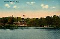
-
Housatonic Railroad track in 1911
-
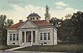
Lee Library in 1909, the only remaining Carnegie library building in the Berkshires
-
Greenock Inn in 1912


Notable People from Lee
- John M. Barlow, politician and businessman
- Nathan B. Bradley, congressman
- Henry Billings Brown, Associate Justice of the U.S. Supreme Court
- Michelle Cuevas, author
- Thomas C. Durant, financier and railroad promoter
- Frank Dwyer, baseball pitcher
- Elisha Foote, judge, inventor, and mathematician
- Henri Gosselin, politician
- Addison H. Laflin, congressman
- Wayne Larrivee, sportscaster
- Debra Jo Rupp, actress
- Augusta Read Thomas, composer
- Elizur Smith, senator and paper manufacturer
- Elizur Yale Smith, socialite, historian
- Wellington Smith, largest American paper manufacturer
- Edward V. Whiton, Chief Justice of the Wisconsin Supreme Court
- Josiah Yale, captain and pioneer of Lee
See also
 In Spanish: Lee (Massachusetts) para niños
