List of extreme points of Canada facts for kids
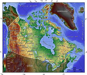
Canada is a huge country! It stretches from the Atlantic Ocean to the Pacific Ocean, and all the way up to the Arctic Ocean. Because it's so big, Canada has many "extreme points." These are the northernmost, southernmost, easternmost, and westernmost spots in the country. Knowing these points helps us understand just how vast Canada truly is. This article will explore some of these amazing locations, including the highest mountains, deepest lakes, and longest rivers.
Contents
Extreme Points of Canada
These are the very edges of Canada, including all its islands.
- Northernmost point — Cape Columbia, on Ellesmere Island, in Nunavut. This is as far north as you can go in Canada! 83°6′41″N 69°57′30″W / 83.11139°N 69.95833°W
- Southernmost point — The south tip of Middle Island, in Ontario. It's located in Lake Erie. 41°40′53″N 82°40′56″W / 41.68139°N 82.68222°W
- Easternmost point — Cape Spear, in Newfoundland. This is the first place in North America to see the sunrise! 47°31′25″N 52°37′10″W / 47.52361°N 52.61944°W
- Westernmost point — Boundary Peak 187, in the Yukon. This spot is right on the border with Alaska. 60°18′23″N 141°0′7″W / 60.30639°N 141.00194°W
Mainland Canada's Extremes
These points are the edges of Canada's main landmass, not including its many islands.
- Northernmost point — Zenith Point, in Nunavut. 72°0′0″N 94°38′59″W / 72.00000°N 94.64972°W
- Southernmost point — Point Pelee, in Ontario. This area is famous for its birds and butterflies. 41°54′33″N 82°30′32″W / 41.90917°N 82.50889°W
- Easternmost point — Cape Saint Charles, in Labrador. 52°13′3″N 55°37′15″W / 52.21750°N 55.62083°W
- Westernmost point — Boundary Peak 187, in the Yukon. This is the same westernmost point for both mainland and all of Canada. 60°18′23″N 141°0′7″W / 60.30639°N 141.00194°W
Canada's Highest Spots
Canada is home to some incredible mountains.
- Mount Logan in the Yukon is Canada's highest mountain. It stands at an amazing 5,959 meters (19,551 feet) tall! 60°34′33″N 140°24′10″W / 60.57583°N 140.40278°W
- Barbeau Peak, on Ellesmere Island in Nunavut, is the highest point on any Canadian island. It's also the tallest mountain in the Canadian Arctic, reaching 2,616 meters (8,583 feet). 81°54′30″N 75°1′30″W / 81.90833°N 75.02500°W
Canada's Lowest Spots
While mountains reach high, some places go very low!
- The coastline is Canada's lowest surface point, which is at sea level.
- The bottom of Great Slave Lake in the Northwest Territories is the lowest freshwater point in North America. It's 458 meters (1,503 feet) below sea level! 61°40′N 114°00′W / 61.667°N 114.000°W
Amazing Canadian Islands
Canada has countless islands, some of them are truly massive.
- Baffin Island, in Nunavut, is Canada's largest island. It covers an area of 507,451 square kilometers (195,928 square miles). 63°33′N 65°26′W / 63.550°N 65.433°W
- Ellesmere Island, also in Nunavut, is Canada's tallest island because it has Barbeau Peak, the highest island mountain. 81°55′36″N 74°59′12″W / 81.92667°N 74.98667°W
- The Island of Newfoundland, in Newfoundland and Labrador, is the biggest Canadian island in the Atlantic Ocean. It's 108,860 square kilometers (42,031 square miles). 49°N 56°W / 49°N 56°W
- Vancouver Island, in British Columbia, is the largest Canadian island in the Pacific Ocean. It spans 31,285 square kilometers (12,079 square miles). 49°30′N 125°30′W / 49.500°N 125.500°W
- Manitoulin Island in Lake Huron, Ontario, is the largest lake island on Earth! It covers 2,766 square kilometers (1,068 square miles). 45°46′N 82°12′W / 45.767°N 82.200°W
Canada's Giant Lakes
Canada is famous for its many lakes, some of which are enormous.
- Lake Superior, in Ontario, holds the most water of any lake in the Western Hemisphere. 47°45′N 87°30′W / 47.750°N 87.500°W
- Great Slave Lake, in the Northwest Territories, is the deepest lake in the Western Hemisphere. It reaches a depth of 614 meters (2,014 feet). 61°40′N 114°00′W / 61.667°N 114.000°W
- Lake Michigan–Huron, which touches Ontario, is considered by some to be the largest freshwater lake on Earth. It covers 117,400 square kilometers (45,300 square miles). 45°49′N 84°45′W / 45.817°N 84.750°W
- Nettilling Lake on Baffin Island, Nunavut, is the largest lake found entirely on an island anywhere on Earth. It's 5,066 square kilometers (1,956 square miles). 66°30′N 70°50′W / 66.500°N 70.833°W
- Lake Manitou on Manitoulin Island in Lake Huron, Ontario, is the largest lake on an island that is itself in a lake! It's 104 square kilometers (40 square miles). 45°46′42″N 81°59′30″W / 45.77833°N 81.99167°W
- Upper Dumbell Lake on Ellesmere Island in Nunavut is the most northern named lake. 82°28′N 062°30′W / 82.467°N 62.500°W
Longest Rivers in Canada
Rivers are like the highways of nature, and Canada has some very long ones.
- The Yukon River, flowing through British Columbia, the Yukon, and into Alaska, is the longest river that flows into the Bering Sea. It's 3,185 kilometers (1,979 miles) long. 62°35′55″N 164°47′40″W / 62.59861°N 164.79444°W
- The Nelson River, in Manitoba, is the longest river that flows into Hudson Bay. It stretches for 2,575 kilometers (1,600 miles). 57°5′5″N 92°30′8″W / 57.08472°N 92.50222°W
- The Columbia River, starting in British Columbia, is the longest Canadian river that flows into the Pacific Ocean. It's 2,000 kilometers (1,200 miles) long. 46°14′39″N 124°3′29″W / 46.24417°N 124.05806°W
- The Mackenzie River, in the Northwest Territories, is the longest Canadian river that flows into the Arctic Ocean. It measures 1,738 kilometers (1,080 miles). 68°56′23″N 136°10′22″W / 68.93972°N 136.17278°W
- The Saint Lawrence River, between Ontario and Quebec, is the longest Canadian river flowing into the Atlantic Ocean. It is 965 kilometers (600 miles) long. 49°40′N 64°30′W / 49.667°N 64.500°W
Longest Drives Across Canada
Imagine driving across Canada! These are some of the longest possible road trips.
- The greatest driving distance between any two points in Canada, including the ferry on the Trans-Canada Highway, is 9,262 km. This epic journey goes from L'Anse Aux Meadows, Newfoundland and Labrador, all the way to Tuktoyatuk, Northwest Territories.
- If you exclude the Trans-Canada Highway Ferry, the longest drive is 9,156 km. This route stretches from Old Fort, Quebec, to Tuktoyatuk, Northwest Territories.
See also
- Geography of Canada
- Extreme points of North America
- Extreme points of Canadian provinces
- Extreme communities of Canada
- Nordicity
- Remote and isolated community


