
Londonderry, New Hampshire facts for kids
Quick facts for kids
Londonderry, New Hampshire
|
||
|---|---|---|
|
From top, left to right: Londonderry Grange #44, Mack's Apples blossoms, gun on the town common, Londonderry United Methodist Church, Mack's Apples farm market
|
||
|
||

Location in Rockingham County and the state of New Hampshire
|
||
| Country | United States | |
| State | New Hampshire | |
| County | Rockingham | |
| Incorporated | 1722 | |
| Villages |
|
|
| Area | ||
| • Total | 42.1 sq mi (109.1 km2) | |
| • Land | 42.0 sq mi (108.8 km2) | |
| • Water | 0.1 sq mi (0.3 km2) 0.30% | |
| Elevation | 420 ft (130 m) | |
| Population
(2020)
|
||
| • Total | 25,826 | |
| • Density | 615/sq mi (237.4/km2) | |
| Time zone | UTC-5 (Eastern) | |
| • Summer (DST) | UTC-4 (Eastern) | |
| ZIP code |
03053
|
|
| Area code(s) | 603 | |
| FIPS code | 33-43220 | |
| GNIS feature ID | 0873651 | |

.jpg)


.jpg)

Londonderry is a town in Rockingham County, New Hampshire, United States. It is located between the cities of Manchester and Derry. Manchester is the largest city in New Hampshire.
In 2020, about 25,826 people lived in Londonderry. The town is famous for its many apple orchards. It is also home to the main office of Stonyfield Farm, a well-known yogurt company. Part of the Manchester–Boston Regional Airport is also in Londonderry.
A more crowded part of Londonderry is called the Londonderry census-designated place (CDP). This area is mostly in the southeastern and southern parts of town. About 11,645 people lived there in 2020.
Contents
Londonderry's History
Early Beginnings

The area where Londonderry is now was first called "Nutfield." This was because of the many nut trees in its thick forests. On September 23, 1719, people living there asked the government to make it a town. They said about 70 families from Ireland and New England had settled there.
On June 21, 1722, the town officially became "Londonderry." It was named after Londonderry in Ireland. The land given to the town was very large.
Over time, parts of Londonderry became other towns.
- Windham became a separate town in 1741.
- Manchester (first called Derryfield) became a town in 1751.
- Derry became its own town in 1827.
The town's borders changed several times until 1857.
In 1719, the very first potato in North America was grown in Derry. At that time, Derry was still part of Londonderry.
The land for Londonderry was bought from Col. John Wheelwright. His family had an old claim to the land. However, this land also overlapped with a grant for the town of Dunstable (now Nashua). This caused land disputes that lasted for many years.
The first U.S. census in 1790 showed Londonderry had 2,622 people.
From the 1800s to World War II
The Manchester and Lawrence Railroad opened in 1849. It had stations in Londonderry, including North Londonderry and Wilson's Crossing. In 1850, a well-known resident was hit and killed by a train. This led the town to ask for gates at all railroad crossings.
A trolley car service, the Manchester and Derry Street Railroad, started in 1907. It connected Derry and Manchester. This service ran until 1926.
- Antique postcards
-

Civil War Soldiers' Monument around 1905
-
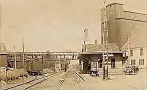
Railroad Station in 1914
-
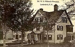
Col. W. S. Pillsbury residence around 1910


After World War II
After World War II, Londonderry grew a lot. This was especially true after Interstate 93 was built. Many people moved to Londonderry, making it a "bedroom community" for larger cities.
Londonderry in the 21st Century
The COVID-19 pandemic caused some disagreements in Londonderry. There were many discussions about whether schools should require masks.
Londonderry's Geography
Londonderry is in the western part of Rockingham County. It shares borders with several towns. These include Auburn, Derry, and Windham in Rockingham County. It also borders Hudson, Litchfield, and Manchester in Hillsborough County.
The town covers about 109.1 square kilometers (42.1 square miles). Most of this area is land (108.8 sq km or 42.0 sq mi). Only a small part, about 0.3 square kilometers (0.1 sq mi), is water.
Several brooks flow through Londonderry. These include Beaver Brook, Little Cohas Brook, Watts Brook, Colby Brook, and Nesenkeag Brook. All of these brooks flow into the Merrimack River. The highest point in Londonderry is Number Eight Hill. It is about 163 meters (535 feet) above sea level.
Londonderry has major roads like Interstate 93, New Hampshire Route 102, New Hampshire Route 128, and New Hampshire Route 28. Half of the Manchester–Boston Regional Airport is located in the northwest part of Londonderry. This includes the main airport building.

Even though Londonderry has grown a lot, it does not have a main downtown area. Historically, it was a farming area, so no central village developed. Londonderry started growing quickly in the 1970s. This was when I-93 made it easier for people to live there and work in nearby cities.
The main shopping areas are in the southeastern part of town. They are near where NH 102 meets I-93. Smaller shopping areas are at the intersection of NH 128 and NH 102, and where NH 28 and NH 128 meet. The Town Hall and schools are located near the center of town, along NH 128.
Neighboring Towns
- Manchester (north)
- Auburn (northeast)
- Derry (east)
- Windham (southeast)
- Hudson (south)
- Litchfield (west)
Londonderry's Climate
Londonderry has four distinct seasons. Winters are long, cold, and snowy. Summers are very warm and a bit humid. Spring and fall are shorter seasons with cool, crisp weather. Rain and snow fall throughout the year.
Londonderry's Population

| Historical population | |||
|---|---|---|---|
| Census | Pop. | %± | |
| 1790 | 2,622 | — | |
| 1800 | 2,650 | 1.1% | |
| 1810 | 2,766 | 4.4% | |
| 1820 | 3,127 | 13.1% | |
| 1830 | 1,469 | −53.0% | |
| 1840 | 1,556 | 5.9% | |
| 1850 | 1,731 | 11.2% | |
| 1860 | 1,717 | −0.8% | |
| 1870 | 1,405 | −18.2% | |
| 1880 | 1,363 | −3.0% | |
| 1890 | 1,220 | −10.5% | |
| 1900 | 1,408 | 15.4% | |
| 1910 | 1,533 | 8.9% | |
| 1920 | 1,303 | −15.0% | |
| 1930 | 1,373 | 5.4% | |
| 1940 | 1,429 | 4.1% | |
| 1950 | 1,640 | 14.8% | |
| 1960 | 2,457 | 49.8% | |
| 1970 | 5,346 | 117.6% | |
| 1980 | 13,598 | 154.4% | |
| 1990 | 19,781 | 45.5% | |
| 2000 | 23,236 | 17.5% | |
| 2010 | 24,129 | 3.8% | |
| 2020 | 25,826 | 7.0% | |
| U.S. Decennial Census | |||
In 2020, Londonderry had 25,826 people living in 9,569 households. About 7,422 of these were families. The town had about 237 people per square kilometer (613 people per square mile).
Most people in Londonderry (93.2%) were White. About 1.9% were Asian, and 0.8% were Black or African American. About 3.7% of the population were Hispanic or Latino.
In Londonderry, 24.9% of the people were under 20 years old. About 32.2% were between 45 and 64 years old. The average age in town was 42.5 years.
The average yearly income for a household in Londonderry was about $110,810. For families, it was about $124,792. Only about 2.0% of the people lived below the poverty line.
Londonderry's Economy

Londonderry is home to many businesses. Many of them are near the Manchester–Boston Regional Airport or Interstate 93. Some major companies based here include Stonyfield Farm and Blue Seal Feeds. A Coca-Cola Bottling Co. plant is also in town. You can also find many chain stores here.
Londonderry has several apple orchards, like Mack's Apples, Sunnycrest Farm, and Elwood Orchards. These farms show the town's history of farming. Apple picking is a very popular activity in the fall.
One old apple orchard is being turned into a large new area called Woodmont Commons. It will have both businesses and homes.
Londonderry's Infrastructure
.jpg)
Londonderry has its own fire department and police department to keep residents safe.
Transportation in Londonderry

Londonderry has several important roads.
- NH 28 goes through North Londonderry. It is known as Rockingham Road.
- NH 102 goes through South Londonderry. It is known as Nashua Road.
- NH 128 is a main road that goes north and south through Londonderry. It is called Mammoth Road.
- Interstate 93 runs through the eastern side of Londonderry. There are two exits for Londonderry: Exit 4 (NH 102) and Exit 5 (NH 28).
The Manchester–Boston Regional Airport is partly in Londonderry. The main airport building is on the Londonderry side. There are no passenger trains in Londonderry.
Londonderry's Education
.jpg)

The Londonderry School District serves the town's students.
- Kindergarten: Moose Hill School (includes LEEP, the Londonderry Early Education Program)
- Elementary Schools: North School, Matthew Thornton Elementary School, South School
- Middle School: Londonderry Middle School
- High School: Londonderry High School (their sports teams are called the Lancers)
Before Londonderry High School opened in 1978, high school students from Londonderry went to Pinkerton Academy in Derry.
There are also several private schools in Londonderry:
- Victory Baptist School (Kindergarten through 12th grade)
- Adventures in Learning
- Applewood Learning Center
- Cozy Kid's Child Care
- Kindercare
- Pixie Preschool I
Londonderry's Media
Local news about Londonderry can be found in the Londonderry Times and the Derry News.
Famous People from Londonderry
- Ant (born 1967), TV host
- Al Baldasaro (born 1956), former politician
- John Bell (1765–1836), former governor of New Hampshire
- Samuel Bell (1770–1850), former governor of New Hampshire
- Silas Betton (1768–1822), former US congressman
- Dom DiMaggio (1917–2009), famous baseball player for the Boston Red Sox
- John Fisher (1806–1882), industrialist and US congressman
- Ryan Griffin (born 1990), football player for the Chicago Bears
- Kevin Hunt (1948–2015), former NFL football player
- Arthur Livermore (1766–1853), former US congressman
- Joseph McKeen (1757–1807), first president of Bowdoin College
- Dan Mullen (born 1972), college football coach
- Ocean Born Mary (1720–1814), a person from a local ghost story
- William M. Oliver (1792–1863), former US congressman
- Ethan Paquin, poet
- George W. Patterson (1799–1879), former US congressman
- Peter Patterson (1825–1904), Canadian politician
- William Patterson (1789–1838), former US congressman
- George Reid (1733–1815), officer in the Revolutionary War
- William Stark (1724–1776), Revolutionary War officer who supported Britain
- Samuel Taggart (1754–1825), former US congressman
- Matthew Thornton (1714–1803), a Founding Father who signed the Declaration of Independence. He lived in a part of Londonderry that is now in Derry.
- Brian Wilson (born 1982), baseball pitcher
- James Wilson (1763–1855), first person to make globes in the US
See also
 In Spanish: Londonderry (Nuevo Hampshire) para niños
