Monroe County, West Virginia facts for kids
Quick facts for kids
Monroe County
|
||
|---|---|---|
|
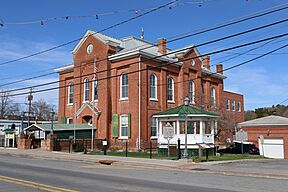
Monroe County Courthouse in Union
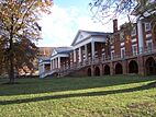
Main Building at Sweet Springs Resort, designed by Thomas Jefferson.
Indian Creek Covered Bridge
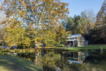
Cook's Mill
|
||
|
||
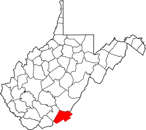
Location of Monroe County in West Virginia
|
||

West Virginia's location within the U.S.
|
||
| Country | ||
| State | ||
| Founded | January 14, 1799 | |
| Named for | James Monroe | |
| Seat | Union | |
| Largest town | Peterstown | |
| Area | ||
| • Total | 1,230 km2 (474 sq mi) | |
| • Land | 1,230 km2 (473 sq mi) | |
| • Water | 2 km2 (0.9 sq mi) 0.2% | |
| Area rank | 20th | |
| Population | ||
| • Estimate
(2023)
|
12,382 |
|
| • Rank | 34th | |
| Time zone | UTC−5 (Eastern) | |
| • Summer (DST) | UTC−4 (EDT) | |
| Area code(s) | 304, 681 | |
| Congressional district | 1st | |
| Senate district | 10th | |
| House of Delegates district | 40th, 47th | |
| Website | https://www.monroecountywv.gov/ | |
Monroe County is a county located in the state of West Virginia, United States. In 2020, about 12,376 people lived there. Its main town and county seat is Union.
Monroe County is famous for a few things. It was home to Andrew Summers Rowan, who was well-known during the Spanish–American War. Also, in 1928, a large diamond called the Jones Diamond was found here! The county even has its own special day, called Farmers' Day.
Contents
History of Monroe County
Monroe County was created on January 14, 1799. It was formed from a part of Greenbrier County. The county was named after James Monroe, who later became the fifth President of the United States.
During the American Civil War, West Virginia became a new state in 1863. Monroe County was included in this new state, even though it didn't officially join. Most of the men from Monroe County who fought in the Civil War joined the Confederate army.
How Monroe County is Organized
In 1863, West Virginia divided its counties into smaller areas called townships. This was meant to help local governments. However, it didn't work well in rural areas. So, in 1872, these townships became "magisterial districts."
Monroe County first had seven townships. Later, some parts were changed, and six townships remained. These six districts stayed mostly the same until the 1990s. Then, they were combined into three new districts: Central, Eastern, and Western.
Geography of Monroe County
Monroe County is in the southeastern part of West Virginia. Its southeastern edge borders the state of Virginia. The New River flows along its southwestern border for a short distance.
The county has many mountains and is covered with trees. Any flat areas are used for farming. The highest point in the county is along its border with Virginia, which is about 3,862 feet (1,177 meters) high. Monroe County covers a total area of about 474 square miles (1,228 square kilometers). Most of this is land, with a small amount of water.
Major Roads in Monroe County
Neighboring Counties
- Greenbrier County (north)
- Alleghany County, Virginia (northeast)
- Craig County, Virginia (east)
- Giles County, Virginia (south)
- Summers County (west)
Rivers and Streams
Monroe County has many rivers and streams. Some of these flow into the James River, which is part of the Chesapeake Bay. Other streams flow into the New River.
- Potts Creek
- Greenbrier River
- Indian Creek
- Second Creek
- Sinks Grove
Special Natural Places
- Greenville Saltpeter Cave is a National Natural Landmark.
- Parts of the George Washington National Forest and Jefferson National Forest are in Monroe County. These are large protected areas.
People of Monroe County
| Historical population | |||
|---|---|---|---|
| Census | Pop. | %± | |
| 1800 | 4,188 | — | |
| 1810 | 5,444 | 30.0% | |
| 1820 | 6,620 | 21.6% | |
| 1830 | 7,798 | 17.8% | |
| 1840 | 8,422 | 8.0% | |
| 1850 | 10,204 | 21.2% | |
| 1860 | 10,757 | 5.4% | |
| 1870 | 11,124 | 3.4% | |
| 1880 | 11,501 | 3.4% | |
| 1890 | 12,429 | 8.1% | |
| 1900 | 13,130 | 5.6% | |
| 1910 | 13,055 | −0.6% | |
| 1920 | 13,141 | 0.7% | |
| 1930 | 11,949 | −9.1% | |
| 1940 | 13,577 | 13.6% | |
| 1950 | 13,123 | −3.3% | |
| 1960 | 11,584 | −11.7% | |
| 1970 | 11,272 | −2.7% | |
| 1980 | 12,873 | 14.2% | |
| 1990 | 12,406 | −3.6% | |
| 2000 | 14,583 | 17.5% | |
| 2010 | 13,502 | −7.4% | |
| 2020 | 12,376 | −8.3% | |
| 2023 (est.) | 12,382 | −8.3% | |
| US Decennial Census 1790–1960 1900–1990 1990–2000 2010–2020, 2023 |
|||
Population in 2010
In 2010, there were 13,502 people living in Monroe County. These people lived in 5,655 households, and 3,915 of these were families. The county had about 28.5 people per square mile.
Most of the people in the county (97.5%) were white. About 0.7% were black or African American, and smaller numbers were American Indian or Asian. About 0.6% of the population was of Hispanic or Latino background.
Many people in Monroe County have Irish, English, or German family roots. The average age of people in the county was 45 years old.
The average income for a household was about $39,574 per year. About 13.3% of the people in the county lived below the poverty line. This included 18.1% of those under 18 years old.
Natural Landmarks
One cool natural spot in Monroe County is Haynes Cave. This cave used to be a mine for saltpeter, which was used to make gunpowder.
In the late 1700s, workers in the cave found some strange bones. They sent these bones to Thomas Jefferson, who later became president. Jefferson studied the bones and realized they belonged to a giant ground sloth! This animal is now called the Megalonyx jeffersonii and is the official state fossil of West Virginia. This discovery helped start the study of ancient life, called paleontology, in America.
There are other saltpeter caves in the area too, like the Greenville Saltpeter Cave. This cave was very important during the War of 1812.
Historic Landmarks
- Indian Creek Covered Bridge
- Rehoboth Church
- Laurel Creek Covered Bridge
Education
Monroe County Schools runs the public schools in the county. Some of these schools include:
- James Monroe High School
- Mountain View Elementary/Middle School
- Peterstown Middle School
- Peterstown Elementary School
Farmers' Day
Farmers' Day is a special yearly event in Union, held on the first Saturday in June. It celebrates the farming families in the area. The event lasts all weekend! It includes a dance on Friday, a 3k run, a pancake breakfast on Saturday, and a parade in Union. There are also other activities on Sunday.
Notable People
- Henry Reed (1884-1968), a famous old-time fiddler and banjo player.
Communities
Towns
- Alderson (part)
- Peterstown
- Union (county seat)
Magisterial Districts
- Central
- Eastern
- Western
Unincorporated Communities
- Ballard
- Ballengee
- Bozoo
- Cashmere
- Cloverdale
- Crimson Springs
- Elmhurst
- Gap Mills
- Gates
- Glace
- Greenville
- Hillsdale
- Hollywood
- Keenan
- Knobs
- Laurel Branch
- Lillydale
- Lindside
- Monitor
- Pickaway
- Raines Corner
- Red Sulphur Springs
- Rock Camp
- Salt Sulphur Springs
- Sarton
- Secondcreek
- Sinks Grove
- Sweet Springs
- Waiteville
- Wayside
- Wikel
- Wolfcreek
- Zenith
See also
 In Spanish: Condado de Monroe (Virginia Occidental) para niños


