Nash County, North Carolina facts for kids
Quick facts for kids
Nash County
|
|||||
|---|---|---|---|---|---|
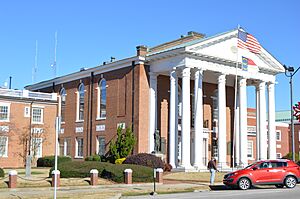
Nash County Courthouse in Nashville
|
|||||
|
|||||
| Motto(s):
"Where Business meets Opportunity"
|
|||||
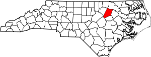
Location within the U.S. state of North Carolina
|
|||||
 North Carolina's location within the U.S. |
|||||
| Country | |||||
| State | |||||
| Founded | 1777 | ||||
| Named for | Francis Nash | ||||
| Seat | Nashville | ||||
| Largest community | Rocky Mount | ||||
| Area | |||||
| • Total | 542.82 sq mi (1,405.9 km2) | ||||
| • Land | 540.44 sq mi (1,399.7 km2) | ||||
| • Water | 2.38 sq mi (6.2 km2) 0.44% | ||||
| Population
(2020)
|
|||||
| • Total | 94,970 | ||||
| • Estimate
(2023)
|
96,551 | ||||
| • Density | 175.73/sq mi (67.85/km2) | ||||
| Time zone | UTC−5 (Eastern) | ||||
| • Summer (DST) | UTC−4 (EDT) | ||||
| Congressional district | 1st | ||||
Nash County is a special area called a county in the state of North Carolina, USA. In 2020, about 94,970 people lived here. The main town where the county government is located is Nashville. Nash County is also part of the larger Rocky Mount city area.
Contents
Exploring Nash County's Past
Nash County has a long and interesting history. It was first part of Edgecombe County. People started settling here in the 1740s. The first official land grants were given in 1743.
How Nash County Was Formed
As more people moved into Edgecombe County, it became hard for those in the western part to travel to the county seat, Tarboro. A lawmaker named Nathan Boddie suggested splitting the county. So, in 1777, Nash County was created from the western parts of Edgecombe.
The county was named after Francis Nash, a brave general in the American Revolutionary War. He was badly hurt in the Battle of Germantown. The first county court meeting happened on April 1, 1778, at Micajah Thomas's home. Later, a temporary building was used until a permanent courthouse was built in Nashville in 1784. Nashville officially became the county seat in 1815 and a town in 1823. The first courthouse burned down in 1833 and was replaced with a new brick building.
Early Life and Growth
In 1786, North Carolina counted 5,277 people in Nash County. By 1790, the first US Census showed 7,393 people. This included 2,099 enslaved people and 183 free Black people.
Many early towns in Nash County grew up along stagecoach routes. These included Dortches, Red Oak, Stanhope, Hilliardston, and Castalia. Settlements also formed near rivers and creeks, where people built gristmills to grind grain.
In the 1830s, the Wilmington and Weldon Railroad was built, bringing more growth. A side rail line built in 1840 helped create the town of Whitakers. By the 1860s, Nash County had over 11,600 people. Its economy was mostly based on farming. In 1855, parts of Nash, Edgecombe, Johnston, and Wayne counties were combined to form Wilson County. More than 1,000 men from Nash County fought in the American Civil War.
Changes and Development After the Civil War
In 1871, a big change happened. Parts of Edgecombe County west of the Wilmington and Weldon Railroad were added to Nash County. This split towns like Battleboro and Sharpsburg between the two counties.
This change also meant more Black residents lived in Nash County. A larger part of Rocky Mount also became part of Nash County. This included Rocky Mount Mills, which was the second textile mill in North Carolina. In 1899, the Atlantic Coast Line Railroad opened repair shops in Rocky Mount. This helped the city grow very quickly. The county's third courthouse was built in 1921.
Understanding Nash County's Geography
Nash County is in the northeastern part of North Carolina. It sits right where the Piedmont region meets the Coastal Plain. The county covers about 542.82 square miles. Most of this (540.44 square miles) is land, and a small part (2.38 square miles) is water. The land in the county slowly gets higher as you go from east to west.
Natural Areas and Waterways
Nash County has some protected natural areas:
- Flower Hill Nature Preserve (part)
- Sandy Creek Game Land (part)
- Shocco Creek Game Land (part)
Many important rivers and creeks flow through Nash County:
- Fishing Creek
- Moccasin Creek
- Pig Basket Creek
- Sapony Creek
- Stoney Creek
- Swift Creek
- Tar River
- Tar River Reservoir
- Toisnot Swamp
- Turkey Creek
Neighboring Counties
Nash County shares borders with these other counties:
Major Roads and Transportation
Nash County is connected by several important highways:

 Future I-87
 I-95
I-95


 Future I-587
 US 64
US 64
 US 64 Alt.
 US 64 Bus. (Nashville)
 US 64 Bus. (Rocky Mount)
 US 264


 US 264 Alt.
 US 301


 US 301 Bus.
 NC 4
NC 4 NC 33
NC 33 NC 43
NC 43
 NC 43 Bus.
 NC 48
NC 48 NC 56
NC 56 NC 58
NC 58 NC 97
NC 97 NC 98
NC 98 NC 231
 NC 561
 NC 581
The Rocky Mount-Wilson Regional Airport also serves the area.
Who Lives in Nash County?
Population Makeup (2020)
In 2020, the US Census counted 94,970 people living in Nash County. There were 37,574 households and 27,002 families.
Here's a look at the different groups of people living in Nash County in 2020:
| Race | Number | Percentage |
|---|---|---|
| White (not Hispanic) | 46,317 | 48.77% |
| Black or African American (not Hispanic) | 36,679 | 38.62% |
| Native American | 615 | 0.65% |
| Asian | 904 | 0.95% |
| Pacific Islander | 28 | 0.03% |
| Other/Mixed | 3,105 | 3.27% |
| Hispanic or Latino | 7,322 | 7.71% |
How the Population Has Changed
| Historical population | ||||||||||||||||||||||||||||||||||||||||||||||||||||||||||||||||||||||||||||||||||||||||||||||||||||||||||||||||
|
||||||||||||||||||||||||||||||||||||||||||||||||||||||||||||||||||||||||||||||||||||||||||||||||||||||||||||||||
Nash County's population grew for many years. However, between 2010 and 2020, the number of people living there went down by almost one percent.
Nash County's Economy
In 2023, the biggest parts of Nash County's economy were:
- Manufacturing (making things)
- Healthcare and social services (hospitals, clinics, helping people)
- Retail (stores)
- Food and accommodation services (restaurants, hotels)
- Education (schools)
The largest private employer is Hospira. This company has a vaccine manufacturing factory in Rocky Mount.
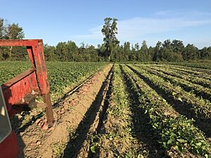
More than 40 percent of Nash County's land is used for farming. The main farm products are poultry (chickens, turkeys), eggs, tobacco, and sweet potatoes. Nash County is one of the top counties in North Carolina for growing sweet potatoes.
Towns and Communities in Nash County
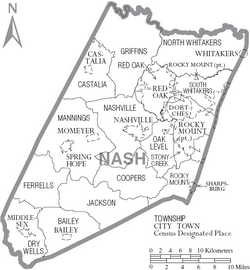
Nash County has several cities, towns, and smaller communities.
Cities in Nash County
- Rocky Mount (This is the largest community. Parts of it are also in Edgecombe County.)
Towns in Nash County
- Bailey
- Castalia
- Dortches
- Middlesex
- Momeyer
- Nashville (This is the county seat, where the main government offices are.)
- Red Oak
- Spring Hope
- Sharpsburg (partly in Nash County)
- Whitakers (partly in Nash County)
- Zebulon (partly in Nash County)
Townships in Nash County
Townships are smaller divisions within a county.
- Bailey
- Castalia
- Coopers
- Dry Wells
- Ferrells
- Griffins
- Jackson
- Mannings
- Nashville
- North Whitakers
- Oak Level
- Red Oak
- Rocky Mount
- Spring Hope
- South Whitakers
- Stony Creek
Unincorporated Community
- Corinth (This is a community that is not officially part of a city or town.)
See also
 In Spanish: Condado de Nash para niños
 | Delilah Pierce |
 | Gordon Parks |
 | Augusta Savage |
 | Charles Ethan Porter |


