National Register of Historic Places listings in Gibson County, Tennessee facts for kids
Imagine a special list that keeps track of important buildings, places, and areas across the United States. This list is called the National Register of Historic Places. It helps protect and celebrate places that tell us about America's past. Gibson County in Tennessee has many such places, and this article will tell you about some of them!
There are 20 different properties and areas in Gibson County, Tennessee that are listed on the National Register. These places are chosen because they have a special history, unique architecture, or are important to the local community.
| Anderson – Bedford – Benton – Bledsoe – Blount – Bradley – Campbell – Cannon – Carroll – Carter – Cheatham – Chester – Claiborne – Clay – Cocke – Coffee – Crockett – Cumberland – Davidson – Decatur – DeKalb – Dickson – Dyer – Fayette – Fentress – Franklin – Gibson – Giles – Grainger – Greene – Grundy – Hamblen – Hamilton – Hancock – Hardeman – Hardin – Hawkins – Haywood – Henderson – Henry – Hickman – Houston – Humphreys – Jackson – Jefferson – Johnson – Knox – Lake – Lauderdale – Lawrence – Lewis – Lincoln – Loudon – Macon – Madison – Marion – Marshall – Maury – McMinn – McNairy – Meigs – Monroe – Montgomery – Moore – Morgan – Obion – Overton – Perry – Pickett – Polk – Putnam – Rhea – Roane – Robertson – Rutherford – Scott – Sequatchie – Sevier – Shelby – Smith – Stewart – Sullivan – Sumner – Tipton – Trousdale – Unicoi – Union – Van Buren – Warren – Washington – Wayne – Weakley – White – Williamson – Wilson |
Historic Places in Gibson County
Gibson County is home to many interesting historic sites. Let's explore some of the buildings and places that have been recognized for their importance.
Homes with a Story
Many of the places on the National Register are old homes that tell us about how people lived in the past.
Bonds House
The Bonds House is located in Humboldt, Tennessee. It was added to the National Register in 2010. This house is a great example of the architecture from its time.
Dodson House
Also in Humboldt, the Dodson House was listed in 1982. It's another important home that shows us the style of houses built long ago in the area.
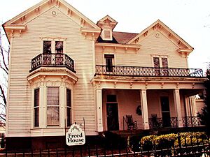
Julius Freed House
The Julius Freed House is found in Trenton, Tennessee. It was added to the list in 1994. This house is a beautiful example of older homes in the county seat.
Senter-Rooks House
The Senter-Rooks House in Humboldt joined the list in 1980. Each of these homes helps us understand the history and development of Gibson County's towns.
Col. Robert Z. Taylor House
In Trenton, the Col. Robert Z. Taylor House was recognized in 1982. It's named after a notable person from the area's past.
Important Public Buildings
Besides homes, many public buildings that served the community are also on the National Register.
Gibson County Courthouse
The Gibson County Courthouse in Trenton is a very important building. It was listed in 1976. Courthouses are often the center of a county's government and history.
Medina City Hall
The Medina City Hall in Medina, Tennessee was added to the list in 2004. City halls are where local government decisions are made and services are provided.
US Post Office Buildings
Two post office buildings in Gibson County are on the list:
- The US Post Office in Milan, Tennessee (listed 1987).
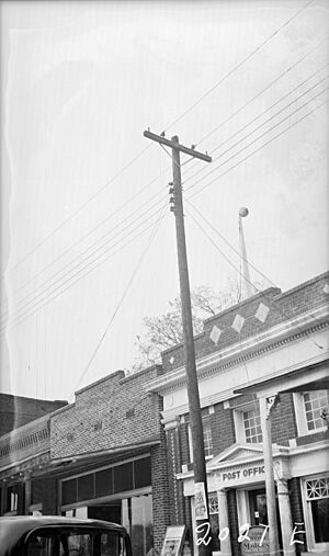
- The US Post Office in Trenton (listed 1988).
These buildings show how important mail services were for connecting communities.
Schools and Education
Schools play a big part in a community's history.
Gibson County Training School
The Gibson County Training School in Milan was added to the National Register in 2012. This school was important for educating students in the area.
Peabody High School
Peabody High School in Trenton was recognized in 1984. Many people from Gibson County attended this school over the years.
Union Central School
The Union Central School near Milan was listed in 1985. These schools represent the history of education and community life in Gibson County.
Other Unique Places
Some places are special because of their unique role or history.
First Methodist Episcopal Church, South
The First Methodist Episcopal Church, South in Humboldt was added to the list in 2008. Churches are often central to a community's social and spiritual life.
Oakland Cemetery
Oakland Cemetery in Trenton was listed in 2007. Cemeteries are important historical sites because they hold the stories of past residents.
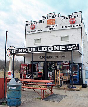
Skullbone Store
The Skullbone Store in Skullbone, Tennessee is a very unique listing, added in 1999. It's a general store that has been a landmark in the small community of Skullbone for a long time.
Trenton Historic District
Instead of just one building, the Trenton Historic District is an entire area in Trenton that was recognized in 1982. This means a whole section of the town has many historic buildings and a special feel that has been preserved.
Browning House
The Browning House is located east of Milan on the Milan Army Ammunition Plant. It was listed in 1974. Its location on a military facility makes it a unique historic site.
These places help us remember and learn about the past of Gibson County and the people who lived there. They are important parts of Tennessee's history!


