
National Register of Historic Places listings in Madison County, Tennessee facts for kids

Welcome to Madison County, Tennessee! Did you know that this area is home to many special places that are protected because of their history? These places are listed on something called the National Register of Historic Places. It's like a special list of important buildings, sites, and areas across the United States.
In Madison County, there are 30 different places on this list. One of them is even more special and is called a National Historic Landmark. These places help us learn about the past and keep history alive for future generations. You can even see where many of these places are on a map using their special location codes.
| Anderson – Bedford – Benton – Bledsoe – Blount – Bradley – Campbell – Cannon – Carroll – Carter – Cheatham – Chester – Claiborne – Clay – Cocke – Coffee – Crockett – Cumberland – Davidson – Decatur – DeKalb – Dickson – Dyer – Fayette – Fentress – Franklin – Gibson – Giles – Grainger – Greene – Grundy – Hamblen – Hamilton – Hancock – Hardeman – Hardin – Hawkins – Haywood – Henderson – Henry – Hickman – Houston – Humphreys – Jackson – Jefferson – Johnson – Knox – Lake – Lauderdale – Lawrence – Lewis – Lincoln – Loudon – Macon – Madison – Marion – Marshall – Maury – McMinn – McNairy – Meigs – Monroe – Montgomery – Moore – Morgan – Obion – Overton – Perry – Pickett – Polk – Putnam – Rhea – Roane – Robertson – Rutherford – Scott – Sequatchie – Sevier – Shelby – Smith – Stewart – Sullivan – Sumner – Tipton – Trousdale – Unicoi – Union – Van Buren – Warren – Washington – Wayne – Weakley – White – Williamson – Wilson |
What is the National Register of Historic Places?
The National Register of Historic Places is the official list of the nation's historic places. It is part of a program to coordinate and support public and private efforts to identify, evaluate, and protect America's historic and archaeological resources.
When a place is added to this list, it means it's important to the history of the local area, the state, or even the whole country. It could be a building, a park, a bridge, or even an archaeological site where people lived long ago. Being on the list helps protect these places and sometimes helps with getting money to fix them up.
Exploring Historic Sites in Madison County
Madison County has many interesting places on the National Register. Let's look at some of them!
Ancient History at Pinson Mounds
One of the most important sites in Madison County is Pinson Mounds. It's so important that it's a National Historic Landmark! This amazing place is an ancient Native American ceremonial center. It was built by people who lived here over 1,000 years ago.
- Name: Pinson Mounds
- Location: Pinson, Tennessee
- Listed: October 15, 1966
At Pinson Mounds, you can see large mounds of earth. These mounds were built by hand. They were used for ceremonies or as burial sites. It's a fantastic place to learn about the early people of Tennessee.
Historic Churches and Buildings
Many churches and important buildings in Madison County are on the list. They show us how people lived and worshipped in the past.
Anderson Presbyterian Church
- Name: Anderson Presbyterian Church
- Location: Madison Hall, Tennessee
- Listed: March 15, 2007
This church is a beautiful old building. It has been a part of the community for many years. It reminds us of the early settlers in the area.
Denmark Presbyterian Church
- Name: Denmark Presbyterian Church
- Location: Denmark, Tennessee
- Listed: June 16, 1983

This church in Denmark is another historic place of worship. Its design and history tell us about the people who built it and used it.
St. Luke Episcopal Church
- Name: St. Luke Episcopal Church
- Location: Jackson, Tennessee
- Listed: May 24, 1984

This church in Jackson is known for its beautiful architecture. It's a significant landmark in the city.
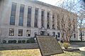
Madison County Courthouse
- Name: Madison County Courthouse
- Location: Jackson, Tennessee
- Listed: March 30, 1995

The courthouse is where important government decisions are made. This historic building has seen many changes in Madison County over the years.
Homes and Neighborhoods with Stories
Some of the places on the list are old homes or even whole neighborhoods. These places give us a peek into how people lived long ago.
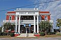
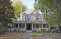
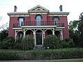
The Cedars
- Name: The Cedars
- Location: Jackson, Tennessee
- Listed: May 5, 1999

"The Cedars" is a historic house with a unique name. It's a great example of older homes in the area.
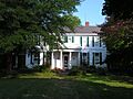
Capt. H. P. Farrar House
- Name: Capt. H. P. Farrar House
- Location: Jackson, Tennessee
- Listed: April 15, 1982

This house belonged to Captain H. P. Farrar. It's a reminder of the people who shaped Jackson's past.
Ross-Sewell House
- Name: Ross-Sewell House
- Location: Jackson, Tennessee
- Listed: January 27, 1983

The Ross-Sewell House is another historic home. It shows us the architectural styles popular in its time.
Bemis Historic District
- Name: Bemis Historic District
- Location: Jackson, Tennessee
- Listed: December 16, 1991
A "historic district" is an area with many historic buildings. The Bemis Historic District includes an old mill. It tells the story of a community built around industry.
East Main Street Historic District
- Name: East Main Street Historic District
- Location: Jackson, Tennessee
- Listed: July 3, 1980

This district covers a part of East Main Street. It has many buildings that show the history of Jackson's downtown area.
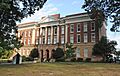
Lane College Historic District
- Name: Lane College Historic District
- Location: Jackson, Tennessee
- Listed: July 2, 1987

Lane College is a historic college. This district includes many of its important buildings. It shows the history of education in the area.
Transportation and Public Places
Even places related to travel and public services can be historic!
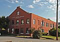
Greyhound Bus Station
- Name: Greyhound Bus Station
- Location: Jackson, Tennessee
- Listed: February 11, 1993

This old bus station was once a busy hub for travelers. It represents a time when bus travel was very popular.
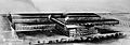
Illinois Central Railroad Division Office
- Name: Illinois Central Railroad Division Office
- Location: Jackson, Tennessee
- Listed: February 11, 1993

Railroads were super important for moving people and goods. This office building was key to managing the trains in the area.
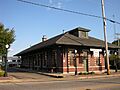
Nashville, Chattanooga & St. Louis Passenger Depot
- Name: Nashville, Chattanooga & St. Louis Passenger Depot
- Location: Jackson, Tennessee
- Listed: February 11, 1993

This old train station was where people would catch trains to other cities. It's a cool example of how people traveled long ago.
Jackson Free Library
- Name: Jackson Free Library
- Location: Jackson, Tennessee
- Listed: June 26, 1975

Libraries are important places for learning. This historic library has served the community for many years.
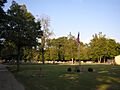
Hollywood Cemetery
- Name: Hollywood Cemetery
- Location: Jackson, Tennessee
- Listed: May 22, 2003

Cemeteries can also be historic sites. They often contain old monuments and tell stories of the people buried there.
Former Listings
Sometimes, a place might be removed from the National Register. This can happen if it changes too much or is no longer considered historically important.
Casey Jones Home and Railroad Museum
- Name: Casey Jones Home and Railroad Museum
- Location: Jackson, Tennessee
- Listed: September 7, 1972
- Delisted: 1980
This museum was once on the list. It honored the famous railroad engineer Casey Jones. Even though it's no longer on the official list, it's still an important part of Jackson's history.
Images for kids
-
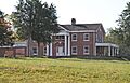
The Cedars, a historic home in Jackson
-
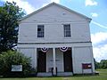
Denmark Presbyterian Church
-

East Main Street Historic District
-
The Capt. H. P. Farrar House
-
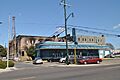
The historic Greyhound Bus Station
-

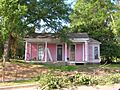
William Holland, Jr., House
-
Hollywood Cemetery
-
Illinois Central Railroad Division Office
-

The Jackson Free Library
-
Lane College Historic District
-
The Madison County Courthouse
-
Murphy Hotel
-
Nashville, Chattanooga & St. Louis Passenger Depot
-
New Southern Hotel
-
Oakslea Place
-
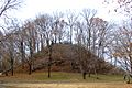
Pinson Mounds
-
The Ross-Sewell House
-
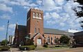
St. Luke Episcopal Church in Jackson
-
Southern Engine and Boiler Works
-
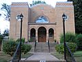
Temple B'Nai Israel
-
William Kirby Walsh House


