
National Register of Historic Places listings in Maury County, Tennessee facts for kids

Welcome to Maury County, Tennessee! This place is full of amazing history, and many of its old buildings and areas are super important. They are so special that they are listed on something called the National Register of Historic Places.
The National Register of Historic Places is like a special list kept by the United States government. It helps protect places that are important to American history, architecture, archaeology, engineering, or culture. When a place is on this list, it means it's recognized for its value and efforts are made to keep it safe for future generations.
In Maury County, there are 69 different places and areas on this list! Two of these are even more special and are called National Historic Landmarks. These landmarks are considered to be among the most important historic places in the entire country.
Let's explore some of these cool historic spots in Maury County!
| Anderson – Bedford – Benton – Bledsoe – Blount – Bradley – Campbell – Cannon – Carroll – Carter – Cheatham – Chester – Claiborne – Clay – Cocke – Coffee – Crockett – Cumberland – Davidson – Decatur – DeKalb – Dickson – Dyer – Fayette – Fentress – Franklin – Gibson – Giles – Grainger – Greene – Grundy – Hamblen – Hamilton – Hancock – Hardeman – Hardin – Hawkins – Haywood – Henderson – Henry – Hickman – Houston – Humphreys – Jackson – Jefferson – Johnson – Knox – Lake – Lauderdale – Lawrence – Lewis – Lincoln – Loudon – Macon – Madison – Marion – Marshall – Maury – McMinn – McNairy – Meigs – Monroe – Montgomery – Moore – Morgan – Obion – Overton – Perry – Pickett – Polk – Putnam – Rhea – Roane – Robertson – Rutherford – Scott – Sequatchie – Sevier – Shelby – Smith – Stewart – Sullivan – Sumner – Tipton – Trousdale – Unicoi – Union – Van Buren – Warren – Washington – Wayne – Weakley – White – Williamson – Wilson |
Contents
Historic Homes and Plantations
Maury County is home to many beautiful old houses, each with its own story.
The Athenaeum
The Athenaeum is a unique building located in Columbia. It was built in the 1830s and later became a school for girls. It's known for its interesting mix of architectural styles.

Beechlawn Advance and Retreat
South of Columbia, you'll find Beechlawn Advance and Retreat. This historic home played a role during the American Civil War. It saw both Union and Confederate soldiers pass by or stay there.
Clifton Place
Clifton Place, southwest of Columbia, is another grand historic home. It was built in the 1830s and is a great example of the large plantations that were once common in this area.
Ewell Farm
In Spring Hill, Ewell Farm is a historic property that has been around since the early 1800s. It's a reminder of the agricultural past of Maury County.

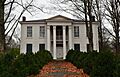
James K. Polk House
One of the most famous homes in Columbia is the James K. Polk House. This was the home of James K. Polk, who became the 11th President of the United States! You can visit it and learn about his life and times. It's one of the two National Historic Landmarks in the county.

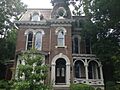
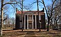
Rattle and Snap
Near Columbia, Rattle and Snap is another National Historic Landmark. This grand mansion was built in the 1840s and is considered one of the finest examples of Greek Revival architecture in the South. It's a truly impressive building!
.jpg)
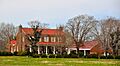
Rippavilla Plantation
South of Spring Hill, Rippavilla Plantation is a historic home that also played a part in the Civil War. It was the site of important events during the Battle of Franklin. Today, you can tour the house and learn about its history.

Historic Churches
Several beautiful and historic churches in Maury County are also on the National Register.
Culleoka Methodist Episcopal Church, South
The Culleoka Methodist Episcopal Church, South in Culleoka is an important part of the town's history. It shows the style of church buildings from the late 1800s.
First United Methodist Church of Columbia
In Columbia, the First United Methodist Church of Columbia is a beautiful example of church architecture. It has been a central part of the community for many years.

Grace Episcopal Church
Grace Episcopal Church in Spring Hill is another historic church. It's known for its lovely design and has served its community for a long time.

St. John's Episcopal Church
West of Columbia, St. John's Episcopal Church is a very old church with a rich history. It's a peaceful place that has stood for many years.

St. Mark United Primitive Baptist Church
The St. Mark United Primitive Baptist Church in Spring Hill is a significant landmark for its community. It represents an important part of the area's religious and social history.

St. Peter's Episcopal Church
Also in Columbia, St. Peter's Episcopal Church is another beautiful and historic place of worship. Its architecture and long history make it a notable site.

Spring Hill Presbyterian Church
The Spring Hill Presbyterian Church is a historic building in Spring Hill. It has been a gathering place for its congregation for many years, reflecting the town's growth and development.

Zion Presbyterian Church
West of Columbia, the Zion Presbyterian Church is a historic rural church. It's a reminder of the early settlements and communities in Maury County.
,_State_Route_1,_Columbia_vicinity_(Maury_County,_Tennessee).jpg)
Other Important Historic Buildings and Districts
Beyond homes and churches, Maury County has other interesting historic places.
Breckenridge Hatter's Shop
In Mount Pleasant, the Breckenridge Hatter's Shop is a unique historic building. It reminds us of the kinds of businesses that existed in the past.

Columbia Arsenal
The Columbia Arsenal in Columbia was once a military training ground. Today, parts of it are still standing and tell the story of its past use.

Columbia Central High School
The Old Columbia Central High School building in Columbia is a historic educational landmark. It served as a place of learning for many generations of students.

Columbia Commercial Historic District
The Columbia Commercial Historic District includes many of the old buildings in downtown Columbia. Walking through this area is like stepping back in time, seeing the shops and businesses from long ago.

Columbia Hydroelectric Station
The Columbia Hydroelectric Station is an interesting example of early power generation. It used the Duck River to create electricity, showing how technology developed over time.

Old Natchez Trace
The Old Natchez Trace is a historic path that stretches through several counties, including Maury County. It was originally used by Native Americans, then by European settlers, traders, and soldiers. It's a very old and important route in American history.

Union Station (Columbia, Tennessee)
The Union Station in Columbia was once a busy train station. It played a big role in transportation and connecting Columbia to other parts of the country.

Former Listings
Sometimes, a place might be removed from the National Register of Historic Places. This can happen for different reasons, like if the building is changed too much or is no longer standing. One example in Maury County was:
Cherry Glen
Cherry Glen was a historic home southwest of Columbia. It was listed on the Register in 1973 but was later removed in 1985.
Images for kids
-
Church House
-

Mayes-Hutton House
-
Mercer Hall
-
Polk Sisters' House
-
Vine Hill
-
Walnut Grove
-
Webster Farm
-
White Hall


.jpg)


