
National Register of Historic Places listings in Tennessee facts for kids
Did you know that Tennessee has a special list of important places? It's called the National Register of Historic Places. This list helps protect buildings, areas, and sites that are really old or have a big story to tell. Think of it like a Hall of Fame for historic spots!
There are over 2,000 places in Tennessee on this list. Some are even more special and are called National Historic Landmarks. These are places that are important to the history of the entire United States. Every single one of Tennessee's 95 counties has at least one place on this list.
The Tennessee Historical Commission helps manage this program in the state. They work to find and list these amazing historic places. If you want to see where these places are, you can often find them on an online map!
| Anderson – Bedford – Benton – Bledsoe – Blount – Bradley – Campbell – Cannon – Carroll – Carter – Cheatham – Chester – Claiborne – Clay – Cocke – Coffee – Crockett – Cumberland – Davidson – Decatur – DeKalb – Dickson – Dyer – Fayette – Fentress – Franklin – Gibson – Giles – Grainger – Greene – Grundy – Hamblen – Hamilton – Hancock – Hardeman – Hardin – Hawkins – Haywood – Henderson – Henry – Hickman – Houston – Humphreys – Jackson – Jefferson – Johnson – Knox – Lake – Lauderdale – Lawrence – Lewis – Lincoln – Loudon – Macon – Madison – Marion – Marshall – Maury – McMinn – McNairy – Meigs – Monroe – Montgomery – Moore – Morgan – Obion – Overton – Perry – Pickett – Polk – Putnam – Rhea – Roane – Robertson – Rutherford – Scott – Sequatchie – Sevier – Shelby – Smith – Stewart – Sullivan – Sumner – Tipton – Trousdale – Unicoi – Union – Van Buren – Warren – Washington – Wayne – Weakley – White – Williamson – Wilson |
Contents
- Discovering Tennessee's Historic Places
- How Many Historic Places Are There?
- A Closer Look at Some Counties
- Benton County's History
- Bledsoe County's Treasures
- Campbell County's Landmarks
- Cannon County's Historic Buildings
- Carroll County's Notable Sites
- Cheatham County's Historic Spots
- Chester County's Landmarks
- Clay County's Historic Places
- Crockett County's Sites
- Cumberland County's Historic Gems
- DeKalb County's Historic Areas
- Decatur County's Sites
- Dyer County's Historic Spots
- Hancock County's History
- Hardin County's Important Places
- Henderson County's Sites
- Houston County's Historic Spots
- Jackson County's Landmarks
- Johnson County's Historic Places
- Lake County's Landmark
- Lauderdale County's Sites
- Lewis County's Historic Spots
- Macon County's Landmarks
- McNairy County's Historic Sites
- Moore County's Famous Places
- Morgan County's Historic Spots
- Overton County's Landmarks
- Perry County's Historic Places
- Pickett County's Sites
- Rhea County's Landmarks
- Scott County's Historic Spots
- Sequatchie County's Sites
- Trousdale County's Landmarks
- Unicoi County's Historic Places
- Union County's Sites
- Van Buren County's Landmarks
- Wayne County's Historic Spots
- Images for kids
Discovering Tennessee's Historic Places
Tennessee is full of history, and many places tell important stories. The National Register of Historic Places helps us remember and protect these special spots.
How Many Historic Places Are There?
As of 2008, there were over 2,000 places listed in Tennessee. This number grows all the time as new historic sites are added. The county with the most listed places is Davidson County, where the state capital, Nashville, is located.


A Closer Look at Some Counties
Let's explore a few counties and some of their unique historic places.
Benton County's History
Benton County, Tennessee has some interesting sites.
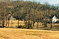
- Reynoldsburg-Paris Road: This old road is part of the Trail of Tears, a sad time in history when Native Americans were forced to move from their homes.
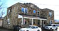
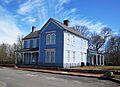
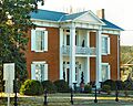
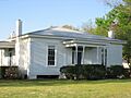
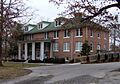
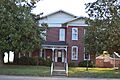
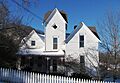
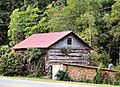
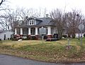
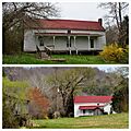
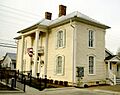
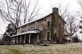
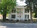
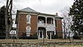
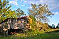
- William Thompson House: A historic house located south of Camden.
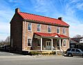
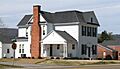
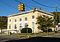
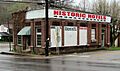
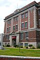
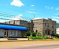
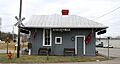
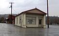
- US Post Office (Camden, Tennessee): This building in Camden has been serving the community since 1988.
Bledsoe County's Treasures
In Bledsoe County, Tennessee, you can find:
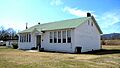
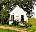
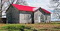
- Bellview School: A rural schoolhouse built in 1928. Today, it's used as a community center.
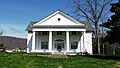
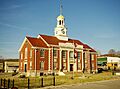
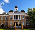
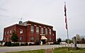
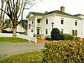
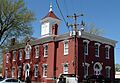
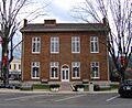
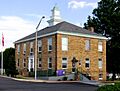
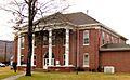
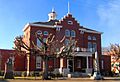
- Bledsoe County Courthouse: The main building for the county government in Pikeville.
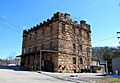
- Bledsoe County Jail: This building still serves as the county's jail.
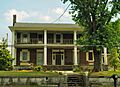
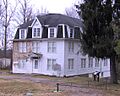
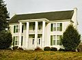
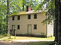
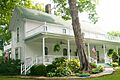
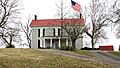
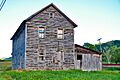
- John Bridgman House: A beautiful house built in 1815 in the Federal style.
- Lincoln School: This was a Rosenwald School, built in the 1920s to educate African Americans.
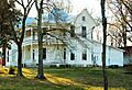
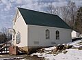
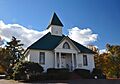
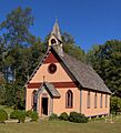
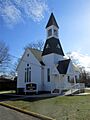
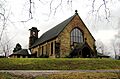
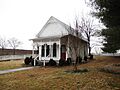
- Pikeville Chapel African Methodist Episcopal Zion Church: This church was originally a school built in 1870 by the Freedmen's Bureau.
Campbell County's Landmarks
Campbell County, Tennessee is home to:
- Jellico Commercial Historic District: This area includes several old buildings along North and South Main Streets in Jellico.
- Kincaid-Howard House: Built in 1845, this house has a long history.
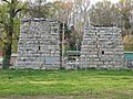
- LaFollette Coke Ovens: These are old ovens used to turn coal into coke, a type of fuel.
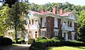
- LaFollette House: Also known as "Glen Oaks," this house was built around 1895.
- Norris Dam: A large dam that also extends into Anderson County.
Cannon County's Historic Buildings
In Cannon County, Tennessee, you can see:
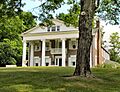
- Baptist Female College-Adams House: Built in 1859 as a dormitory for a college.
- Brevard-Macon House: A house built in 1900 that is still owned by the family who built it.
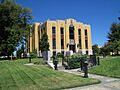
- Cannon County Courthouse: The courthouse was built in 1935.
- Ready-Cates Farm: This farm was started in the 1840s and includes a house from around 1870.
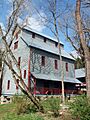
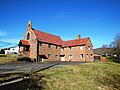
- Readyville Mill: An old mill located on U.S. Route 70S.
Carroll County's Notable Sites
Carroll County, Tennessee features:
- Court Theatre (Huntingdon, Tennessee): A historic theater building.
- First Cumberland Presbyterian Church-McKenzie: A church with a long history in McKenzie.
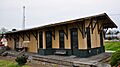
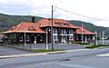
- McKenzie Depot: An old train station in McKenzie.
Cheatham County's Historic Spots
In Cheatham County, Tennessee, you'll find:
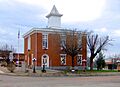
- Cheatham County Courthouse: The county's main government building.
- Montgomery Bell Tunnel: A very important site that is also a National Historic Landmark.
- Mound Bottom: An ancient Native American site along the Harpeth River.
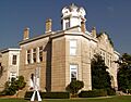
Chester County's Landmarks
Chester County, Tennessee has:
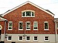
- Chester County Courthouse (Tennessee): The courthouse in Henderson.
- National Teacher's Normal and Business College Administration Building: An important building from a former college.
Clay County's Historic Places
- Clay County Courthouse (Tennessee): The courthouse in Celina.
- Free Hills Rosenwald School: Another Rosenwald school built around 1925 to educate African Americans. It was used until 1966.
Crockett County's Sites
Crockett County, Tennessee includes:
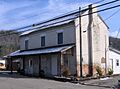
- Bank of Alamo: An old bank building in Alamo.
- Fruitvale Historic District: A historic area along Fruitvale Road.
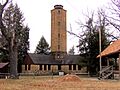
Cumberland County's Historic Gems
Cumberland County, Tennessee offers:
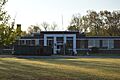
- Camp Nakanawa Wigwam: A unique building at Camp Nakanawa.
- Crossville Tennessee Highway Patrol Building: This building now serves as the Tennessee Native Stone Museum.
- Cumberland County Courthouses: This listing includes both the current courthouse (built 1905) and the old courthouse (built 1886), which is now a museum.
- Cumberland Homesteads Historic District: This area includes many houses and public buildings from a planned community built in the 1930s.
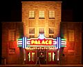
- Palace Theater (Crossville, Tennessee): An Art Deco style theater built in 1936, now a community center.
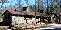
- Pioneer Hall (Pleasant Hill, Tennessee): Once part of the Pleasant Hill Academy, it's now a local museum.
DeKalb County's Historic Areas
- Alexandria Cemeteries Historic District: A historic area with cemeteries.
- DeKalb County Fairgrounds: The fairgrounds where the county fair is held.
- Liberty Historic District (Liberty, Tennessee): A historic area along Main Street in Liberty.
Decatur County's Sites
Decatur County, Tennessee has:
- Dr. Beauregard Martin Brooks House: A historic house near Bath Springs.
- John P. Rains Hotel: An old hotel in Parsons.
Dyer County's Historic Spots
- Bank of Dyersburg: A historic bank building.
- Dyersburg Courthouse Square Historic District: The historic area around the courthouse.
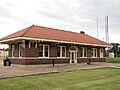
- Newbern Illinois Central Depot: An old train station in Newbern.
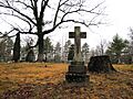
- Pleasant Hill Cemetery (Finley, Tennessee): A historic cemetery.
Hancock County's History
Hancock County, Tennessee includes:
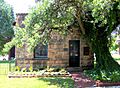
- Old Jail (Sneedville, Tennessee): A historic jail building.
- Vardy Community School: While the school building has fallen down, other parts of this historic district are still standing.
Hardin County's Important Places
- Cherry Mansion: A historic mansion in Savannah.
- Savannah Historic District (Savannah, Tennessee): A historic area in Savannah.
- Shiloh Indian Mounds Site: An important Native American site.
- Shiloh National Military Park: A large park that remembers a major battle from the American Civil War.
Henderson County's Sites
Henderson County, Tennessee has:
- Thompsie Edwards House: A historic house in Lexington.
- Montgomery High School (Lexington, Tennessee): A historic school building.
- Mount Pisgah Missionary Baptist Church and Cemetery: A historic church and cemetery.
- Parker's Crossroads Battlefield: The site of a Civil War battle.
Houston County's Historic Spots
- Erin Limekilns: Old kilns used to make lime.
- V.R. Harris House: A historic house in Erin.
- Quarry Limekiln: Another historic limekiln.
Jackson County's Landmarks
Jackson County, Tennessee features:
- Fort Blount-Williamsburg Site: The site of an old fort and a town.
- Gainesboro Historic District: A historic area in Gainesboro.
- Jackson County High School (Gainesboro, Tennessee): A historic school building.
Johnson County's Historic Places
- Butler House (Mountain City, Tennessee): The home of Congressman Roderick R. Butler, built around 1870.
- Alfred Johnson Farm: A historic farm.
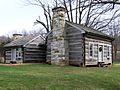
- Morrison Farm and Store: This includes a farmhouse and a log store.
- Dr. Wiley Wagner Vaught Office: A doctor's office built around 1905.
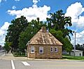
Lake County's Landmark
- Caldwell-Hopson House: A historic house in Tiptonville.
Lauderdale County's Sites
In Lauderdale County, Tennessee:
- Fort Pillow: An important site and National Historic Landmark.
- Lauderdale County Courthouse (Tennessee): The courthouse in Ripley.
- Alex Haley House and Museum: The home of famous author Alex Haley.
Lewis County's Historic Spots
Lewis County, Tennessee features:
- Ambrose Blackburn Farmstead: A historic farm.
- Hohenwald Railroad Depot: An old train station.
- Lewis County Courthouse (Tennessee): The courthouse in Hohenwald.
- Old Natchez Trace: A very old historic road that runs through several counties.
- Steele's Iron Works (40LS15): An old iron works site.
Macon County's Landmarks
- Belview School: A historic school building.
- Cloyd Hotel: Now called the Thomas House, this was a historic hotel.
- Counts Hotel: Now called the Armour Hotel, another historic hotel.
- Donoho Hotel Historic District: This historic hotel is still open today!
- Red Boiling Springs Bank: Built in 1928, this building was a bank until 1963.
McNairy County's Historic Sites
McNairy County, Tennessee has:
- Bethel Springs Presbyterian Church: A historic church.
- Big Hill Pond Fortification: An old fortification site.
- Davis Bridge Battlefield: A Civil War battlefield that also extends into Hardeman County.
Moore County's Famous Places
- Bobo Hotel: Built in the late 1850s, this was a boarding house and a meeting place for Jack Daniel's executives.
- Jack Daniel Distillery: The famous distillery where Jack Daniel's whiskey is made.
- Lynchburg Historic District: This area includes many historic buildings in downtown Lynchburg.
- Moore County Courthouse and Jail (Tennessee): The courthouse was built in 1885, and the old jail (now a museum) was built in 1893.
Morgan County's Historic Spots
Morgan County, Tennessee features:
- R.M. Brooks General Store and Residence: This building also served as a post office for Rugby.
- Rugby Colony: A historic planned community that also extends into Scott County.
- Wartburg Presbyterian Church: A historic church.
Overton County's Landmarks
- Alpine Institute: A Presbyterian mission school that operated from 1821 to 1947.
- American Legion Bohannon Post #4: A building from the 1940s.
- Overton County Courthouse: The courthouse in Livingston.
- Gov. Albert H. Roberts Law Office: The law office of former Governor Albert H. Roberts.
- Standing Stone State Park: This park has many structures built by the Civilian Conservation Corps (CCC) in the 1930s and 1940s.
Perry County's Historic Places
Perry County, Tennessee includes:
- Dr. Richard Calvin Bromley House: A historic house.
- Cedar Grove Furnace (40PY77): An old furnace site.
- Perry County Courthouse (Tennessee): The courthouse in Linden.
Pickett County's Sites
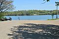
- Cordell Hull Birthplace State Park: The birthplace cabin of Cordell Hull, who was a U.S. Secretary of State.
- Pickett County Courthouse: The courthouse in Byrdstown.
- Pickett State Rustic Park Historic District: This park has structures built by the CCC in the 1930s and 1940s.
Rhea County's Landmarks
Rhea County, Tennessee features:
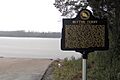
- Blythe Ferry: A historic ferry site on the Tennessee River. It also extends into Meigs County.
- Hastings-Locke Ferry: Another historic ferry site on the Tennessee River, also extending into Meigs County.
- Hiwassee Garrison Site: A historic site on the west bank of the Tennessee River.
- Rhea County Courthouse: This courthouse is a National Historic Landmark.
Scott County's Historic Spots
- Barton Chapel: A historic chapel.
- First National Bank of Huntsville: A historic bank building.
- Old Scott County Jail (Huntsville, Tennessee): The old jail building.
- Rugby Colony: This historic district also extends into Morgan County. The Scott County part includes Laurel Dale Cemetery.
Sequatchie County's Sites
Sequatchie County, Tennessee includes:
- Douglas Coal and Coke Company Clubhouse: Built for business visitors to the coal company.
- Dunlap Coke Ovens: The ruins of old ovens used to make coke from coal.
- Dunlap Community Building: Built between 1938 and 1942, it's now the Sequatchie County Library.
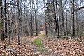
- Hill Road at the Cumberland Plateau: Another site related to the Trail of Tears.
- Sequatchie County Courthouse: The courthouse in Dunlap.
Trousdale County's Landmarks
In Trousdale County, Tennessee:
- Averitt-Herod House: Originally built in 1832.
- James R. DeBow House: An Italianate-style house built between 1854 and 1870.
- Hartsville Battlefield: A historic battlefield.
- Hartsville Depot: An old train station that now houses the Chamber of Commerce.
- Hartsville Historic District: A historic area in Hartsville.
Unicoi County's Historic Places
Unicoi County, Tennessee features:
- A.R. Brown House: A historic house in Erwin.
- Clarksville Iron Furnace: An old iron furnace located in the Cherokee National Forest.
- Clinchfield Depot: An old train station in Erwin.
Union County's Sites
- Booker Farm: A historic farm.
- Hamilton-Lay Store: An old store building.
- Maynardville State Bank: A historic bank building.
- Baite Ousley House: Also known as the Jacob Sharp House, built by Jacob Sharp.
Van Buren County's Landmarks
Van Buren County, Tennessee includes:
- Big Bone Cave: A large and historic cave.
- Crain Hill School and Church: Built in 1870, this served as both a school and a church.
- Rocky River Crossing and Road: Another site related to the Trail of Tears.
Wayne County's Historic Spots
- Collinwood Railroad Station: Built in 1916, it's now a library and museum.
- Evans Chapel United Methodist Church: A historic church.
- First Presbyterian Church of Clifton: A historic church.
- Old Natchez Trace: This historic road also runs through Wayne County.
- Waynesboro Cumberland Presbyterian Church: The congregation was founded in 1846, and the church was built in 1854.
Images for kids
-
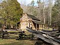
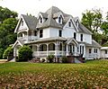
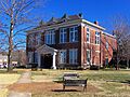
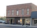
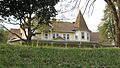
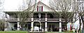
The William Thompson House in Camden.
-
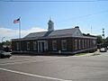
The U.S. Post Office in Camden.
-
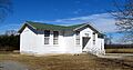
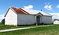
The Bellview School, now a community center.
-
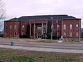
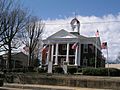
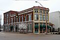
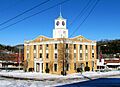
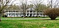
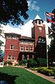
The Bledsoe County Courthouse.
-
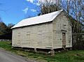
The Bledsoe County Jail.
-
The John Bridgman House, built in 1815.
-
The Lincoln School, a former Rosenwald school.
-
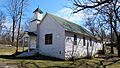
The Pikeville Chapel African Methodist Episcopal Zion Church.
-
The Dr. James A. Ross House, now a museum.
-
A building in the South Main Street Historic District in Pikeville.
-
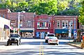
The intersection of North and South Main Streets in Jellico.
-
The Kincaid-Howard House.
-
The LaFollette House, also known as "Glen Oaks."
-
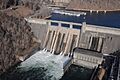
Norris Dam.
-
The A.E. Perkins House.
-
The Smith-Little-Mars House.
-
The U.S. Post Office and Mine Rescue Station in Jellico.
-
The Baptist Female College-Adams House.
-
The Brevard-Macon House.
-
The Cannon County Courthouse.
-
The Ready-Cates Farm.
-
The Readyville Mill.
-
The First Cumberland Presbyterian Church-McKenzie.
-
The McKenzie Depot.
-
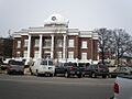
The Cheatham County Courthouse.
-
The Montgomery Bell Tunnel.
-
Mound Bottom.
-
The Chester County Courthouse.
-
The Hamlett-Smith House.
-
The National Teacher's Normal and Business College Administration Building.
-
The Clay County Courthouse.
-
The Free Hills Rosenwald School.
-
The Camp Nakanawa Wigwam.
-
The Crossville Tennessee Highway Patrol Building.
-
The Cumberland County Courthouse.
-
A tower in the Cumberland Homesteads Historic District.
-
The Cumberland Mountain School.
-
The Palace Theater in Crossville.
-
Pioneer Hall, now a museum.
-
The Greenberry Wilson House.
-
The Alexandria Cemeteries Historic District.
-
The DeKalb County Fairgrounds.
-
The Evans Block in Smithville.
-
Liberty Town Hall in the Liberty Historic District.
-
The John P. Rains Hotel.
-
The Bank of Dyersburg.
-
The Dyer County Courthouse.
-
The Edward Moody King House.
-
Pleasant Hill Cemetery.
-
A building in the Troy Avenue Historic District.
-
The Old Jail in Sneedville.
-
The Vardy Community Presbyterian Church.
-

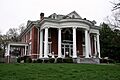
The Cherry Mansion.
-
A building in the Savannah Historic District.
-
The Shiloh Indian Mounds Site.
-
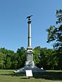
The Iowa Monument at Shiloh National Military Park.
-
Steele's Iron Works.
-
The Thompsie Edwards House.
-
Montgomery High School.
-
Parker's Crossroads Battlefield.
-
The Erin Limekilns.
-
The V.R. Harris House.
-
The Quarry Limekiln.
-
The Fort Blount-Williamsburg Site.
-
The Jackson County Courthouse.
-
A house in the Gainesboro Residential Historic District.
-

The Jackson County High School.
-
The Butler House.
-
The Alfred Johnson Farm.
-
Maymead Farm.
-
The Morrison Farm and Store.
-
The Dr. Wiley Wagner Vaught Office.
-
The Caldwell-Hopson House.
-
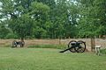
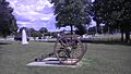
Cannons at Fort Pillow State Park.
-
The Lauderdale County Courthouse.
-
The Alex Haley House and Museum.
-
The Hohenwald Railroad Depot.
-
The Lewis County Courthouse.
-
The Old Natchez Trace.
-
The Ambrose Blackburn Farmstead.
-
The Belview School.
-
The Cloyd Hotel (now Thomas House).
-
The Counts Hotel (now Armour Hotel).
-
The Donoho Hotel.
-
The Galen Elementary School.
-
The Long Creek School.
-
The Red Boiling Springs Bank.
-
The Bethel Springs Presbyterian Church.
-
The Bobo Hotel.
-
The Green-Evans House.
-
The Jack Daniel Distillery.
-
A house in the Lynchburg Historic District.
-
The Moore County Courthouse.
-
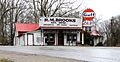
The R.M. Brooks General Store and Residence.
-
Christ Church in Rugby Colony.
-
The Wartburg Presbyterian Church.
-
The Alpine Presbyterian Church.
-
The American Legion Bohannon Post #4.
-
The Officer Farmstead.
-
The Overton County Courthouse.
-
The Gov. Albert H. Roberts Law Office.
-
A building in the Standing Stone Rustic Park Historic District.
-
The Perry County Courthouse.
-
The Cordell Hull Birthplace cabin.
-
The Pickett County Courthouse.
-
The Recreation Lodge at Pickett State Park.
-
The Blythe Ferry site.
-
The Broyles-Darwin House.
-
The Hastings-Locke Ferry site.
-
The Hiwassee Garrison Site.
-
The Rhea County Courthouse.
-
The Dr. Walter Thomison House.
-
Barton Chapel.
-
The First National Bank of Huntsville.
-
The Old Scott County Jail.
-
Laurel Dale Cemetery in the Rugby Colony.
-
The Douglas Coal and Coke Company Clubhouse.
-
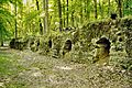
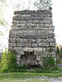
The Dunlap Coke Ovens.
-
The Dunlap Community Building.
-
Hill Road at the Cumberland Plateau, a Trail of Tears site.
-
The Sequatchie County Courthouse.
-
The Averitt-Herod House.
-
The James R. DeBow House.
-
The Hartsville Depot.
-
The Trousdale County Courthouse.
-
The Clinchfield Depot.
-
The Booker Farm house.
-
The Hamilton-Lay Store.
-
The Hamilton-Tolliver Complex barn.
-
The Maynardville State Bank.
-
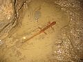
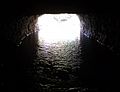
A cave salamander at Big Bone Cave.
-
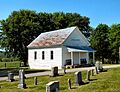
The Crain Hill School and Church.
-
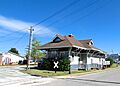
The Collinwood Railroad Station.
-
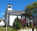
The Waynesboro Cumberland Presbyterian Church.


.jpg)


.jpg)


