
National Register of Historic Places listings in Monroe County, Tennessee facts for kids

Have you ever wondered about the special places in your community that tell a story about the past? In Monroe County, Tennessee, there are many such places! They are listed on something called the National Register of Historic Places. This is like a special list kept by the United States government to honor important buildings, sites, and objects that have a lot of history.
When a place is on this list, it means it's worth protecting because it helps us understand the history of our country, state, or local area. Monroe County has 19 places on this list, and one of them is even a National Historic Landmark, which is an even higher honor! Let's explore some of these amazing historic spots.
| Anderson – Bedford – Benton – Bledsoe – Blount – Bradley – Campbell – Cannon – Carroll – Carter – Cheatham – Chester – Claiborne – Clay – Cocke – Coffee – Crockett – Cumberland – Davidson – Decatur – DeKalb – Dickson – Dyer – Fayette – Fentress – Franklin – Gibson – Giles – Grainger – Greene – Grundy – Hamblen – Hamilton – Hancock – Hardeman – Hardin – Hawkins – Haywood – Henderson – Henry – Hickman – Houston – Humphreys – Jackson – Jefferson – Johnson – Knox – Lake – Lauderdale – Lawrence – Lewis – Lincoln – Loudon – Macon – Madison – Marion – Marshall – Maury – McMinn – McNairy – Meigs – Monroe – Montgomery – Moore – Morgan – Obion – Overton – Perry – Pickett – Polk – Putnam – Rhea – Roane – Robertson – Rutherford – Scott – Sequatchie – Sevier – Shelby – Smith – Stewart – Sullivan – Sumner – Tipton – Trousdale – Unicoi – Union – Van Buren – Warren – Washington – Wayne – Weakley – White – Williamson – Wilson |
Contents
- Historic Places in Monroe County
- Dams and Engineering Marvels
- Ancient Cherokee Village Sites
- Historic Buildings and Homes
- Cooke-Kefauver House: A Grand Home
- First Presbyterian Church: A Place of Worship
- William J. Fowler Mill and House: Old-Time Industry
- Elisha Johnson Mansion: A Historic Residence
- John McCroskey House: A Mid-1800s Home
- Monroe County Courthouse: The Heart of the County
- Charles Owen House: An Early American Style
- Scott Mansion: A Grand Estate
- Stickley House: Greek Revival Beauty
- Forts and Trading Posts
- Former Listings
- Images for kids
Historic Places in Monroe County
Monroe County is home to many fascinating historic sites, from ancient Native American villages to old churches and grand houses. Each one has a unique story to tell about the people and events that shaped this area.
Dams and Engineering Marvels
Calderwood Dam: A Powerhouse of History
The Calderwood Dam is a huge structure on the Tennessee River. It was built to create electricity and is a great example of early 20th-century engineering. It was added to the National Register in 1989.
Ancient Cherokee Village Sites
Monroe County is rich in the history of the Cherokee people. Many of their ancient villages were located here. While some of these sites are now underwater due to Tellico Lake, their history is still remembered and honored with monuments.
Chota and Tanasi: Important Cherokee Towns
The sites of Chota and Tanasi were once very important Cherokee villages in the 1700s. These archaeological sites are now covered by Tellico Lake, but monuments stand along the shoreline to remember their significance. They were added to the National Register in 1973.
Citico Site: Another Cherokee Village
The Citico Site was also an 18th-century Cherokee village. Like Chota and Tanasi, this archaeological site is now submerged by Tellico Lake. It was listed in 1978.
Icehouse Bottom: A Glimpse into Ancient Life
The Icehouse Bottom site is an archaeological spot that shows us how people lived during the Archaic and Woodland periods, thousands of years ago! It was excavated in the early 1970s and is now also submerged by Tellico Lake. It joined the National Register in 1978.
Mialoquo Site: A Hidden History
The Mialoquo Site was another 18th-century Cherokee village. This archaeological site is also now under the waters of Tellico Lake. It was added to the National Register in 1978.
Tomotley Site: A Village Remembered
The Tomotley site was an 18th-century Cherokee village. This archaeological site is now submerged by Tellico Lake, but its history is preserved on the National Register since 1978.
Toqua Site: Exploring the Past
The Toqua Site was another important 18th-century Cherokee village. This archaeological site is also submerged by Tellico Lake. It was listed on the National Register in 1978.
Historic Buildings and Homes
Monroe County has many beautiful old buildings that show us how people lived and built things in the past.
Cooke-Kefauver House: A Grand Home
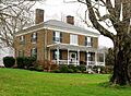
The Cooke-Kefauver House is a historic home located on Kefauver Lane in Madisonville. It was recognized for its historical importance in 1988.
First Presbyterian Church: A Place of Worship
The First Presbyterian Church in Sweetwater is a beautiful church built in 1887. Its style is called Gothic Revival, which means it looks like old European churches with pointed arches and tall windows. The church congregation started in 1860, and the building was added to the National Register in 2001.
William J. Fowler Mill and House: Old-Time Industry
The William J. Fowler Mill and House in Eve Mills shows us what an old mill and home looked like. It was listed in 1983.
Elisha Johnson Mansion: A Historic Residence
The Elisha Johnson Mansion on Ballplay Road in Tellico Plains is another historic home. It was added to the National Register in 1974.
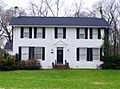
John McCroskey House: A Mid-1800s Home
The John McCroskey House in Sweetwater was built in 1859. This historic home was added to the National Register in 2000.
Monroe County Courthouse: The Heart of the County
The Monroe County Courthouse is located on Town Square in Madisonville. Courthouses are often important historic buildings because they are where local government and justice happen. This one was listed in 1995.
Charles Owen House: An Early American Style
The Charles Owen House in Sweetwater is a Federal-style house built in the late 1820s. Federal style was popular in the early years of the United States. It was added to the National Register in 1998.
Scott Mansion: A Grand Estate
The Scott Mansion near Tellico Plains is another significant historic home. It was listed in 1993.
Stickley House: Greek Revival Beauty
The Stickley House in Madisonville is a beautiful Greek Revival-style house. It was built in 1846 and designed by an architect named Thomas Blanchard. Greek Revival style was popular in the 1800s and looks like ancient Greek temples. It was added to the National Register in 1974.
Forts and Trading Posts
Fort Loudoun: A National Historic Landmark
Fort Loudoun near Vonore is a very special place. It's not just on the National Register; it's a National Historic Landmark! This means it's one of the most important historic sites in the entire country. Fort Loudoun was a British fort built in the 1750s during the French and Indian War. It was listed in 1966.
Tellico Blockhouse: An Old Trading Spot
The Tellico Blockhouse site near Vonore was an important trading outpost in the late 1700s. Today, you can see where the blockhouse stood, marked by posts and stones, with signs that explain its history. It was added to the National Register in 1975.
Former Listings
Sometimes, a historic place might be removed from the National Register. This usually happens if the building is destroyed or changed so much that it no longer looks like it did historically.
McGhee Mansion: A Lost Treasure
The McGhee Mansion near Vonore, also known as Tuskega, was once on the National Register. Sadly, it burned down in 1984 and was removed from the list in 1985.
Images for kids
-
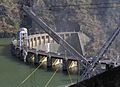
The impressive Calderwood Dam.
-
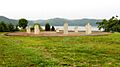
A monument marking the historic Chota village site.
-

The mouth of Citico Creek, near the historic Citico site.
-
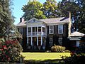
The historic Cooke-Kefauver House.
-
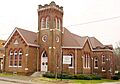
The First Presbyterian Church in Sweetwater.
-

A view of Fort Loudoun.
-
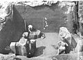
Archaeological excavations at Icehouse Bottom in the 1970s.
-
The John McCroskey House.
-
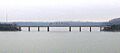
A view from U.S. Route 411, near the Mialoquo Site.
-
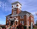
The Monroe County Courthouse.
-
The Charles Owen House.
-
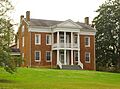
The historic Stickley House.
-
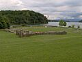
The site of the Tellico Blockhouse.
-

The Tomotley site.
-

The Toqua site.


