North Branch Buffalo Creek facts for kids
Quick facts for kids North Branch Buffalo Creek |
|
|---|---|

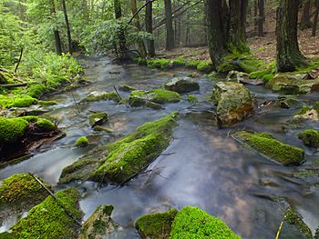
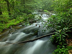
North Branch Buffalo Creek in The Hook Natural Area
|
|
| Physical characteristics | |
| Main source | wetland in Haines Township, Centre County, Pennsylvania between 1,720 and 1,740 feet (520 and 530 m) |
| River mouth | Buffalo Creek in West Buffalo Township, Union County, Pennsylvania 531 ft (162 m) ACoordinates: Unknown argument format |
| Length | 13.5 mi (21.7 km) |
| Basin features | |
| Progression | Buffalo Creek → West Branch Susquehanna River → Susquehanna River → Chesapeake Bay |
| Basin size | 22.9 sq mi (59 km2) |
| Tributaries |
|
North Branch Buffalo Creek is a cool stream in Pennsylvania. It flows for about 13.5 miles (21.7 km) through Centre County and Union County. This creek is a branch of a bigger stream called Buffalo Creek. It has two smaller streams that join it: Panther Run and Coal Run. The land around the creek, called its watershed, covers about 22.9 square miles (59 km2).
The creek winds through mountains and its water is mostly clean. Some parts of the creek are special because they have "Exceptional Value" or are "High-Quality Coldwater Fishery" areas. This means the water is very clean and healthy for fish. You can find different types of trout here, some that live naturally and some that are added by people. The creek is also home to many tiny creatures called benthic macroinvertebrates, which shows it's a healthy place.
Most of the land around the creek is covered by forests. But there are also farms and even a water supply reservoir called the Mifflinburg Reservoir. Long ago, people used the creek's power for mills. Today, it's a great spot for nature lovers. It flows through Bald Eagle State Forest and a special place called The Hook Natural Area. There are also many hiking trails nearby for you to explore!
Contents
Where Does the Creek Flow?
North Branch Buffalo Creek starts in a wetland in Haines Township, Centre County. A wetland is a marshy area with lots of water and special plants. From there, it flows east-northeast through a deep, narrow valley. After a short distance, it leaves Centre County.
The creek then enters Hartley Township in Union County. It keeps flowing east-northeast through the valley for a few miles. It passes between two mountains, Buck Ridge and Dogback Mountain. Then, it turns south-southeast. Here, it meets Panther Run, its first named tributary, which flows into it from the left side. The creek also goes past Ice Spring and the western edge of Jones Mountain.
Next, the creek turns east for more than a mile, flowing between Jones Mountain and Little Mountain. It then reaches Lewis Township and turns east-southeast. After a while, it turns northeast and then east-northeast, flowing through the Mifflinburg Reservoir. This reservoir holds water for people to use.
Further downstream, the valley around the creek gets much wider. The creek flows east for a few miles. Then, it turns south-southeast for a few miles, passing by Lake McClure. Here, it meets its second tributary, Coal Run, which joins from the right side. Finally, after flowing southeast for a bit, North Branch Buffalo Creek joins the larger Buffalo Creek.
North Branch Buffalo Creek meets Buffalo Creek about 13.34 miles (21.5 km) before Buffalo Creek reaches its own mouth.
Smaller Streams Joining the Creek
North Branch Buffalo Creek has two named smaller streams, or tributaries: Coal Run and Panther Run.
- Coal Run joins North Branch Buffalo Creek about 0.46 miles (0.74 km) upstream from its mouth. The land area that drains into Coal Run is about 5.33 square miles (13.8 km2).
- Panther Run joins North Branch Buffalo Creek about 9.42 miles (15.16 km) upstream from its mouth. The land area that drains into Panther Run is about 3.79 square miles (9.8 km2).
Water Quality of the Creek
Some parts of North Branch Buffalo Creek's watershed have water quality issues. These problems are mainly caused by too many nutrients and too much sedimentation or siltation from farming activities like grazing. Nutrients can make too many algae grow, and too much sediment can make the water cloudy and harm fish.
However, the creek is not affected by acid rain, which is good news! On November 29, 1945, the amount of water flowing in the creek upstream of the Mifflinburg Reservoir was measured at 6.28 cubic feet per second (0.178 m3/s).
Scientists have measured the amount of sediment, nitrogen, and phosphorus in the creek. These are important for understanding water health. For example, in 2008, the creek carried about 1,147,538 pounds (520,510 kg) of sediment. A lot of this sediment comes from the creek banks themselves and from farm fields. Efforts are being made to reduce these amounts to make the water even cleaner.
The water in a stream within The Hook Natural Area, which is part of this watershed, sometimes looks dark amber. This color comes from decaying plants and other natural materials in the groundwater that flows into the creek. It's a natural process!
Land and Rocks Around the Creek
The land around North Branch Buffalo Creek changes from its start to its end. The creek's source (where it begins) is high up, between 1,720 and 1,740 feet (520 and 530 m) above sea level. Its mouth (where it joins Buffalo Creek) is lower, at 531 feet (162 m) above sea level. The creek generally flows east, but it takes a winding path.
At the very start of the creek, the rocks contain carbonate minerals like limestone and dolomite. These kinds of rocks can affect the water's chemistry. The creek flows through a narrow valley with steep hills, surrounded by mountains like Jones Mountain and Buffalo Mountain. Its channel is sinuous, meaning it has many curves and bends. The rocks in its path are mostly sandstone.
In some areas, the creek has a braided channel, which means it splits into several smaller, interwoven streams. The soil near the creek is often a gravelly loam called Elkinsville gravelly loam. This soil is good for plants and helps filter the water.
In the early 1900s, the area around the creek received about 40 to 45 inches (100 to 110 cm) of rain each year.
The Creek's Watershed and Land Use
The watershed of North Branch Buffalo Creek covers 22.9 square miles (59 km2). Most of this area, about 22.09 square miles (57.2 km2), is in Union County. The creek's mouth is near Mifflinburg, and its source is near Woodward.
The watershed has about 32.1 miles (51.7 km) of streams in total. About 3.2 miles (5.1 km) of these streams flow through agricultural land. Generally, the creek flows through the countryside, including farms and meadows.
A large part of the watershed, about 87 percent, is covered by forests. Another 9 percent is used for agriculture, including row crops and hay/pastures. A small part, about 2 percent, is covered by impervious surfaces like roads and buildings.
The Mifflinburg Reservoir on North Branch Buffalo Creek is an important source of drinking water for the town of Mifflinburg. There are also about 1.1 miles (1.8 km) of unpaved roads in the watershed. The creek's mouth is about 1 mile (1.6 km) northeast of Mifflinburg.
A Look Back: History of the Creek
North Branch Buffalo Creek was officially added to the Geographic Names Information System on August 2, 1979. It has also been known by other names like Branch Run and North Branch Run.
In 1771, a man named Jacob Fought bought land at the mouth of the creek. He built the first gristmill in the area there. A gristmill uses water power to grind grain into flour. For a time, this spot was even used as a place for people to vote!
Historically, North Branch Buffalo Creek powered many small mills. These mills made things like flour, lumber, wool, and cider. They were very important for the local community. However, these mills are no longer in operation today.
Logging, which is cutting down trees for wood, happened in parts of the watershed between 1893 and 1896. There were even railroads in the area to help move the logs. But in the early 1900s, the state of Pennsylvania bought this land, and it is now The Hook Natural Area, a protected natural space. In the early 1900s, not many people lived in the watershed. Farming was the main activity, and the creek also supplied water to Mifflinburg.
Several bridges have been built over North Branch Buffalo Creek over the years. Some older bridges, built in 1954, are now closed. A newer bridge, built in 1972, carries State Route 3007 over the creek.
In 2008, experts ranked the North Branch Buffalo Creek watershed as the sixth most important area for restoration efforts within the larger Buffalo Creek area. This means people are working to keep its waters healthy and clean.
Animals and Plants in the Creek
The water in North Branch Buffalo Creek is very important for fish. The parts of the creek upstream of the Mifflinburg Water Supply Dam are considered "Exceptional Value" and a "Migratory Fishery." This means the water is super clean and important for fish that travel to lay eggs. Downstream from the dam, it's a "High-Quality Coldwater Fishery" and still a Migratory Fishery.
Wild trout naturally live and reproduce in the creek from its start all the way to its mouth. Some parts of the creek are even classified as a Class B trout stream, which is a good sign for trout fishing. People also add brown trout and rainbow trout to certain parts of the creek. You can also find brook trout here, which are native to the area.
The creek has a healthy population of benthic macroinvertebrates. These are small creatures like insect larvae that live at the bottom of the stream. They are a sign of good water quality.
The land around the creek is also home to many plants. In the wetland where the creek starts, you can find shrub swamps and conifer swamps. Shrub swamps have plants like speckled alder and sedges. Conifer swamps have trees like eastern hemlock and rhododendron, along with peat moss and other shrubs and herbs.
The Hook Natural Area, which the creek flows through, used to have many hemlock, white oak, and white pine trees. Today, you'll see different trees like red maple, white oak, red oak, scarlet oak, black oak, and chestnut oak. You might also spot white birch, yellow birch, and black birch.
Fun Things to Do at the Creek
North Branch Buffalo Creek is a great place for outdoor activities! Part of it flows through Bald Eagle State Forest and The Hook Natural Area. You can reach the creek from nearby villages like Johnstown and Red Bank.
There are many hiking trails that follow the creek closely, especially up to the Mifflinburg Reservoir. Some popular trails in the area include the Frederick Trail and the Braucher Path. The famous Mid State Trail also passes near the creek's headwaters.
While the creek was once used for mills and logging, today it's mostly enjoyed for fun and relaxation. You can explore the beautiful natural surroundings, go fishing, or simply enjoy a walk along the water. The Buffalo Mills Hunting Camp, which was once used by lumberjacks, is also in the area.
 | Calvin Brent |
 | Walter T. Bailey |
 | Martha Cassell Thompson |
 | Alberta Jeannette Cassell |


