
North Indian Ocean tropical cyclone facts for kids
In the Indian Ocean north of the equator, tropical cyclones can form throughout the year. These powerful storms are most common between April and June, and again from October to December.
Even though this part of the Indian Ocean has fewer cyclones than other places (only about 7% of the world's total), the storms here can be very dangerous. This is because they often hit areas where many people live.
The India Meteorological Department (IMD) is a special group that watches these storms. They give warnings and names to the cyclones to help keep people safe.
Contents
Exploring the North Indian Ocean's Stormy Waters

The northern Indian Ocean is split into two main areas where cyclones form: the Bay of Bengal and the Arabian Sea.
The Bay of Bengal: A Busy Storm Zone
The Bay of Bengal is in the northeast part of the Indian Ocean. It's often called BOB by weather experts. Many countries share its coastline, including India, Bangladesh, Myanmar, Sri Lanka, and parts of Thailand. This bay is known for having many powerful and sometimes very dangerous cyclones. For example, the 1999 Odisha cyclone was one of the strongest ever seen here.
The Arabian Sea: Where Monsoons Meet Cyclones
The Arabian Sea is in the northwest of the Indian Ocean. Weather experts call storms here ARB. Its shores are shared by countries like Pakistan, India, Yemen, Oman, the UAE, Iran, Sri Lanka, Maldives, and Somalia. The Arabian Sea is famous for its Monsoons, which are seasonal winds that bring a lot of rain to the Indian subcontinent. While cyclones are less common here, they can still be very strong. Cyclone Gonu was one of the most powerful and expensive storms recorded in this sea.
A Look Back: How We Learned About Cyclones
People have been studying tropical cyclones in the Bay of Bengal and Arabian Sea for a long time. In the 1800s, a scientist named Henry Piddington started keeping detailed records. He used information from ship logs to track storms and wrote about them. This helped us understand how these storms move and behave.
Naming Storms and Measuring Their Strength
In 2004, the IMD started giving names to tropical cyclones. The very first one was called Cyclone Onil in September 2004. Naming storms helps people talk about them and remember them easily.
In 2015, the way we measure how strong a cyclone is changed a bit. Now, a storm with very fast winds (between 167 and 222 kilometers per hour) is called an extremely severe cyclonic storm.
How Cyclones Form and Move
When and Where Cyclones Appear
Each year, about five to six tropical cyclones form in this part of the world. They mostly appear from March to June and again from October to December. May and November are the busiest months for storms.
Most of these storms start in the Bay of Bengal. They can form in the southeastern part of the bay, in the Andaman Sea, or even be leftover storms from the South China Sea. The warm ocean water and lots of moisture in the air here help cyclones grow strong.
The Arabian Sea has fewer cyclones. This is because its waters are sometimes cooler, and there are stronger winds higher up in the atmosphere that can break storms apart.
The Journey of a Cyclone
Most cyclones in this region first travel towards the northwest. Then, they often change direction, either turning towards the southwest or the northeast. It's more common for them to curve towards the northeast.
In the Arabian Sea, storms usually head towards the Arabian Peninsula. But sometimes, they turn northeast and hit the Gujarat coast in India. In the Bay of Bengal, cyclones typically move northwest until they reach the eastern coast, then they often turn northeast.
How Cyclones Get Stronger
Cyclones are most likely to get stronger in April, May, and November. During these months, many smaller storms, called depressions, grow into full-blown cyclonic storms or even severe cyclonic storms. More than half of these depressions become storms, and about a quarter become powerful cyclones.
Where Cyclones Hit Land
Arabian Sea Landfalls
Many storms in the Arabian Sea weaken and disappear over the ocean before reaching land. However, some do hit the western coast of India, especially the states of Gujarat and Maharashtra. A smaller number of storms also reach the Arabian Peninsula, the Horn of Africa, or Pakistan. Very rarely, a storm like Cyclone Gonu in 2007, or Kyarr, can even reach Iran.
Bay of Bengal Landfalls
In the Bay of Bengal, most cyclones hit the Indian states of Odisha or West Bengal. Many also strike Andhra Pradesh and Tamil Nadu. About 30% of these cyclones affect countries like Bangladesh, Sri Lanka, and Myanmar. The rest simply fade away over the sea without ever reaching land.
Climate Change and Stronger Storms
Scientists believe that climate change is affecting cyclones in the North Indian Ocean. We've seen more powerful storms and a trend of storms getting stronger very quickly. For example, in 2019, the Arabian Sea had eight cyclonic storms, which was a record high.
Warmer Oceans, Stronger Cyclones
Research shows that the ocean's surface temperature in the Arabian Sea has gone up by about 1.2 to 1.4 degrees Celsius in recent years. Warmer water acts like fuel for cyclones, making them more powerful and helping them form faster. Before Cyclone Amphan became very strong, the Bay of Bengal's water was as warm as 33 degrees Celsius!
Rising Sea Levels and Coastal Flooding
The Ministry of Earth Sciences also reports that very severe cyclonic storms are happening more often. This is a concern because warmer oceans also lead to rising sea levels. Higher sea levels can cause more severe flooding and dangerous storm surges when a cyclone hits the coast. This puts coastal towns and communities at greater risk.
Cyclone Seasons: A Look at the Numbers

The North Indian Ocean experiences different cyclone seasons. Here's a chart showing how many storms of different strengths formed each month between 1990 and 2020:
|
10
20
30
40
50
60
Jan
Feb
Mar
Apr
May
Jun
Jul
Aug
Sep
Oct
Nov
Dec
|
Recent Cyclone Seasons (2010s)

The 2010s saw many significant cyclones. For example, Cyclone Phailin in 2013 was a very strong storm, similar to a Category 5 hurricane. In 2019, Cyclone Kyarr became the first "Super Cyclonic Storm" in this region since 2007.
Latest Cyclone Seasons (2020s)

The 2020s have also had notable cyclone activity. Cyclone Amphan in 2020 was a "Super Cyclonic Storm" and caused the most damage of any cyclone recorded in this basin. In 2023, Cyclone Mocha was one of the strongest cyclones ever to form in the North Indian Ocean.
Amazing Cyclone Records
- The strongest tropical cyclone ever recorded in this basin was the 1999 Odisha Cyclone. It hit the Indian state of Odisha with winds of 260 kilometers per hour.
- The cyclone that caused the most damage was Cyclone Amphan in 2020. It cost about $13.2 billion, which was more than Cyclone Nargis in 2008.
- The deadliest tropical cyclone was the 1970 Bhola Cyclone. It caused over 500,000 deaths in the Ganges-Brahmaputra delta region.
- The smallest tropical cyclone was Cyclone Ogni in 2008, which had a diameter of only 100 kilometers.
- The largest tropical cyclone was also the 1999 Odisha Cyclone.
- The wettest tropical cyclone was Severe Cyclonic Storm ARB 01 in 2004. One weather station recorded 184 centimeters of rain in just a few days!
Images for kids
-
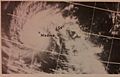
This ESSA 3 satellite image was taken on November 3, 1966, at 0819 UTC of a tropical cyclone striking Madras, India
-
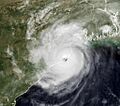
The 1999 Odisha Cyclone making landfall over Odisha in 1999.
-
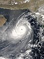
Cyclone Gonu at its peak in 2007.


See Also
- Tropical cyclone
- Atlantic hurricane season
- Pacific hurricane season
- Pacific typhoon season
- South-West Indian Ocean tropical cyclone
- Australian region tropical cyclone
- South Pacific tropical cyclone
- South Atlantic tropical cyclone
- Mediterranean tropical-like cyclone
