
Northside (Jacksonville) facts for kids
Quick facts for kids
Northside
North Jacksonville
|
|
|---|---|
     from the left, Blount Island Marine Terminal, Jacksonville Zoo Asian Bamboo Garden, Kingsley Plantation, Jacksonville International Airport and Big Talbot Island State Park Beach, photo by Steven H. Keys, Tripofalifestyle.com.
|
|

Vernacular regions of Jacksonville:
1. Urban core 2. Arlington 3. Southside 4. Westside 5. Northside 6. Beaches |
|
| Country | |
| State | |
| City | |
| Population
(2017)
|
|
| • Total | 156,001 |
| ZIP Code |
32208, 32209, 32218, 32219, 32226
|
| Area code(s) | 904 |
The Northside is a large area in Jacksonville, Florida. It is one of the main parts of the city, like the Urban Core, Arlington, Southside, Westside, and the Beaches. This big region has old communities, important places, nature preserves, and key transportation hubs. All these things have helped Jacksonville grow over time.
The Northside became part of Jacksonville in 1968. This happened because the city and Duval County governments joined together. This joining is called the Jacksonville Consolidation. The Northside is home to many important transportation spots. These include Jacksonville International Airport, the main train station, and several large shipping terminals. The Jacksonville Zoo and Gardens is also in the Northside. It moved there in 1925 and has grown a lot since then. People generally think the Northside is north of the Urban Core and Westside, starting around 20th Street. It also stretches west and north of the St. Johns River.
Contents
Exploring the Northside's Past
Early History and Settlements
The Northside area is very old. Scientists have found some of the oldest pottery in the United States here. This pottery was found on Black Hammock Island within the Timucuan Ecological and Historic Preserve. They also found items from the Mocama chiefdoms and signs of a Spanish mission. People have lived in the Mocama Province area for at least 4,500 years.
A Spanish mission called San Juan del Puerto was built near the mouth of the St. Johns River. It was on Fort George Island before 1587. This mission served the Saturiwa, a Timucua tribe living there. Father Francisco Pareja worked at this mission. He created a writing system for the Timucua language and taught it to some Mocama people. In 1612, he printed a book in Spanish and Timucua. This was the first book ever printed in a native language of the Americas.
This mission was one of three main Spanish missions in the Mocama Province. The Spanish left the mission around 1702. This was partly because of attacks from Native Americans and English colonists. These attacks happened during Queen Anne's War.
Plantations and New Ownership

Great Britain took control of Florida in 1763. They quickly started several large farms called plantations in the area. Richard Hazard had the first plantation on Fort George Island in 1765. He grew indigo using many enslaved Africans. Spain got Florida back in 1783 after the American Revolution. They offered free land to new Americans.
In 1793, American Revolution veteran John McQueen came to Fort George Island. The Spanish government gave him the island. McQueen settled there with 300 enslaved people and built a big house. But he soon went bankrupt. John McIntosh from Georgia took over the plantation in 1804. He made it successful again. However, McIntosh tried to make Florida part of the United States. When he failed, he fled back to Georgia to avoid punishment from the Spanish.
Zephaniah Kingsley moved to Fort George Island in 1814. He leased the land from McIntosh. In 1817, he bought the land and buildings for $7,000. Today, this place is known as Kingsley Plantation. Free Black people and several private owners lived there. The State of Florida took over the plantation in 1955. The National Park Service got it in 1991. The main house, kitchen, and many slave quarters are still standing.
Growing Neighborhoods and the Zoo
The Northside began to grow as a suburb of Jacksonville in the 1800s. Panama Park saw major growth after 1905. A new school was built there in 1915. It was designed by the famous architect Henry J. Klutho. By 1931, Panama Park became part of Jacksonville. Tallulah-North Shore, a neighborhood next to Panama Park, was planned in 1879. It was added to Jacksonville in 1925.
Riverview is a neighborhood bordered by the Trout River to the north and east. Dr. E.H. Armstrong planned Riverview in 1911. He also turned his waterfront home into Riverview Tropical Gardens. This was a place with boating, fishing, and beautiful garden trails. In 1979, the city bought the land and made it a public park.
On July 19, 1925, the Jacksonville Zoo and Gardens moved to a 37.5-acre site on the Trout River. It was located off Heckscher Drive. The zoo had been in the Springfield neighborhood since 1914.
Airports and City Growth

The Jacksonville Municipal Airport opened on October 11, 1927. It was at the corner of North Main Street and Busch Drive. Charles Lindbergh attended the opening ceremony. He flew his plane, the "Spirit of St. Louis", to Jacksonville to promote the new airport. Eastern Air Service was the first airline to serve Jacksonville, starting in 1931.
By 1941, the airport had grown to 600 acres. It had five hangars, a terminal building, and five runways. The airport was renamed Imeson Field in the 1950s. It was named after Thomas Cole Imeson, who helped create and improve the airport. Imeson Field was the city's main airport for 42 years. Jacksonville International Airport, also in the Northside, opened on September 1, 1968. It replaced Imeson Field.
On October 1, 1968, the city and county governments merged. This created the Consolidated City of Jacksonville. Voters had approved this plan the year before. Services like fire, police, health, and parks were all combined. This merger created a very large city area of 900 square miles. The Jacksonville Consolidation was supported by many people. They wanted lower taxes, more economic growth, and better city services.
Modern Transportation and Shopping
Amtrak's Jacksonville station opened in 1974. It replaced the old downtown Union Station. This station serves trains like the Silver Meteor and Silver Star. It also connects to bus services.
Construction of the Dames Point Bridge started in 1985 and finished in 1989. This bridge crosses the St. Johns River. It connects Arlington to the Northside of Jacksonville. It is a cable-stayed design. When it was finished, it was the longest concrete cable-stayed bridge in the world.
The JAXPORT Cruise Terminal opened in 2003. It was built quickly as a temporary structure. This cruise ship terminal is near the Dames Point Bridge. It is on the northern bank of the St. Johns River. Carnival Cruise Lines began service from Jacksonville in 2004. In 2005, five cruise ships were used as floating hotels for Super Bowl XXXIX. As of 2019, cruises from Jacksonville visit the Bahamas and Eastern Caribbean.
River City Marketplace opened on November 17, 2006. It is the only large outdoor shopping mall in the Northside. This 125-acre shopping area is located near Interstate 95. When fully built, it will have cost over $300 million and have more than 100 stores.
Northside Geography and Nature
Defining the Northside Area
The Northside is one of the major regions of Jacksonville. It includes areas in the northern part of the city. There isn't one exact boundary for the Northside. However, studies show it's generally north of the Urban Core and Westside at 20th Street. It also stretches west and north of the St. Johns River.
Rivers and Islands
The Trout River is a key natural feature of the Northside. This 20-mile-long river flows into the St. Johns River. It is salty in its lower parts. The Trout River has wetlands near the mouth of its longest branch, the Ribault River.
The Ribault River is named after Jean Ribault, a French naval officer. Its source is near Old Kings Road, about 7 feet above sea level. The river flows northward, just like the St. Johns River. The Ribault River is 6.4 miles long.
Black Hammock Island is an island in a marshy area near Jacksonville. It is very close to the Timucuan Ecological and Historic Preserve. Cedar Point is located at the southern end of Black Hammock Island.
Neighborhoods of the Northside
The Northside is a large area with many neighborhoods. Some of these include:
- Black Hammock Island
- Brentwood
- Dinsmore
- Fort George Island
- Garden City
- Highlands
- Lake Forest
- Longbranch
- Moncrief Park
- Norwood
- Panama Park
- Pecan Park
- Oceanway
- Ribault
- Riverview
- Royal Terrance
- San Mateo
- Tallulah-North Shore
-
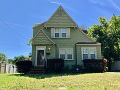
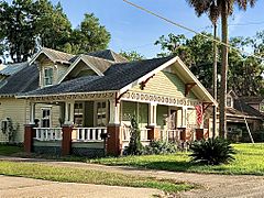
A home in Brentwood.
-
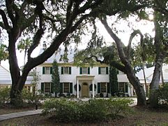
The Ribault Club on Fort George Island.
-
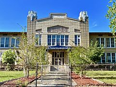
Public School No. 13 in Panama Park.
-
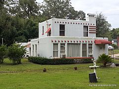
The Rathel House in Riverview.
-
A home in Tallulah-North Shore.


Parks and Green Spaces
The Northside has many protected natural areas. These are managed by different groups. They include the National Park Service, Florida State Parks, and the City of Jacksonville.
National Parks
The Timucuan Preserve is a U.S. National Preserve. It covers over 46,000 acres of wetlands and waterways. It includes natural and historic sites. These are the Fort Caroline National Memorial and the Kingsley Plantation. Kingsley Plantation is the oldest standing plantation in Florida.
State Parks
Several state parks are located in the Northside:
- Big Talbot Island State Park
- Fort George Island Cultural State Park
- George Crady Bridge Fishing Pier State Park
- Little Talbot Island State Park
- Pumpkin Hill Creek Preserve State Park
- Yellow Bluff Fort Historic State Park
City Parks
Jacksonville has the largest urban park system in the United States. It has over 337 parks covering more than 80,000 acres. City parks in the Northside include:
- Alimacani Park: This park is on State Road A1A. It's a great spot for bird watching. It also has a boat ramp for river access.
- Betz-Tiger Point Preserve: This preserve is surrounded by saltwater marsh. You can see many animals here, like gopher tortoises, birds, and dolphins. It is next to Pumpkin Hill Creek Preserve State Park.
- Cedar Point Preserve: Located on Black Hammock Island, this park is home to many bird species.
- Huguenot Memorial Park: This park is on the Atlantic Ocean. It is between the St. Johns River and the Fort George Inlet. The park has a fee to enter. It offers campsites, rental cabins, and a nature center.
- Seaton Creek Historic Preserve: This 840-acre park is thought to be where the southernmost battle of the American Revolution happened. It has three trails for hiking, biking, and horseback riding.
- Thomas Creek Conservation Area: This historical preserve is part of the Black Creek system. It's a great place for kayaking and canoeing.
- Sheffield Park: This 385-acre park was once a dairy farm. It has two large ponds.
Cemeteries
The Northside is home to some important cemeteries:
- Jacksonville National Cemetery
- Evergreen Cemetery: This is a large historic cemetery. It was added to the National Register of Historic Places in 2011.
- Memorial Cemetery: This cemetery has the Lewis Mausoleum. It is the resting place of Abraham Lincoln Lewis. He was an important businessman in the African-American community.
Private Preserves
Other groups also work to preserve land in the Northside for the public good:
- Jacksonville Zoo and Gardens: This zoo has over 2,400 rare animals and 1,500 unique plant species. It helps protect endangered animals.
- East Coast Greenway
- Machaba Balu Preserve
Education in the Northside
The Duval County Public Schools district runs public schools in the Northside. These include:
- Andrew Jackson High School
- Jean Ribault High School
- First Coast High School
Higher Education Opportunities
The North Campus of Florida State College at Jacksonville opened in 1970. It is one of four campuses in the city. In 2009, Florida changed its laws. This allowed some community colleges to become "state colleges". This means they can offer more bachelor's degrees. FCCJ was one of the first to make this change. It changed its name to "Florida State College at Jacksonville" in 2009.
The North Campus is located off Dunn Avenue, near I-295. It has many of the college's health programs. These include nursing, dental hygiene, and emergency medical services. The North Campus also has the Culinary Institute of the South. This is a culinary school with its own restaurant. There is also a cosmetology program. The North Campus includes the college's baseball and softball fields.
Getting Around the Northside
Airports

Jacksonville International Airport (JAX) is a major airport for passengers. It has direct flights to many big U.S. cities. The airport opened in the Northside in 1968. It replaced Imeson Field, which also used to be in the Northside.
The airport covers 7,911 acres. It has two concrete runways. The airport terminal has a baggage claim area on the first floor. The ticketing area is on the second floor. Beyond that is the mezzanine with shops, restaurants, and security. The airport has two main concourses, A and C, with 10 gates each.
In 2018, the airport served over 6.4 million passengers. This was a new record. This growth led to plans to rebuild concourse B. The new concourse could open by 2022. It would add six more gates.
Public Transportation
The Northside is served by several Jacksonville Transportation Authority (JTA) bus routes. These routes help people get around the area. Some of the routes include:
- 1 North Main
- 3 Moncrief
- 4 Kings
- 11 A. Philip Randolph
- 12 Myrtle / Lem Turner
- 21 Boulevard/ Gateway
- 22 Avenue B
- 51 Edgewood
- 81 Dinsmore Shuttle
- 82 Amazon Shuttle
- First Coast Flyer Green (a fast bus service)
Major Roads
Important highways in the Northside include:
 Interstate 95: This highway goes north to Washington, D.C. and south to Miami.
 Interstate 295: This road circles around the city. It connects to all the other interstate highways.
Other major roads are:
 US 1
US 1 US 17
US 17 US 23
US 23 State Road 115
 State Road A1A: This is a scenic two-lane road along the Atlantic Ocean.
Ferries
The Saint Johns River Ferry, also known as the Mayport Ferry, has been running since 1874. It travels between Mayport and Fort George Island. The trip is about 0.9 miles long. It crosses the Saint Johns River about 2.5 miles from the river's mouth. Ferries still leave daily every half-hour.
