Northwest Arctic Borough, Alaska facts for kids
Quick facts for kids
Northwest Arctic Borough
|
||
|---|---|---|

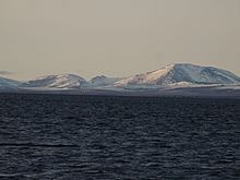
The Kotzebue Sound as seen from Cape Krusenstern National Monument.
|
||
|
||

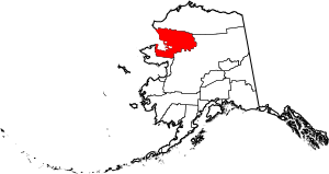
Location within the U.S. state of Alaska
|
||
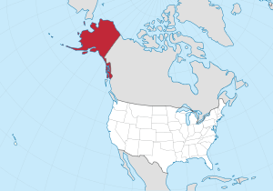
 Alaska's location within the U.S. |
||
| Country | ||
| State | ||
| Incorporated | June 2, 1986 | |
| Named for | Northwest and Arctic location | |
| Seat | Kotzebue | |
| Largest city | Kotzebue | |
| Area | ||
| • Total | 40,749 sq mi (105,540 km2) | |
| • Land | 35,573 sq mi (92,130 km2) | |
| • Water | 5,176 sq mi (13,410 km2) 12.7% | |
| Population
(2020)
|
||
| • Total | 7,423 | |
| • Density | 0.182164/sq mi (0.070334/km2) | |
| Time zone | UTC−9 (Alaska) | |
| • Summer (DST) | UTC−8 (ADT) | |
| Congressional district | At-large | |
The Northwest Arctic Borough is a special area in Alaska. It's like a county in other states. In 2020, about 7,793 people lived here. The main town and government center is Kotzebue. This borough was officially created on June 2, 1986.
Contents
Geography of Northwest Arctic Borough
The Northwest Arctic Borough is very large! It covers about 40,749 square miles. Most of this is land (35,573 square miles), and the rest is water (5,176 square miles). To give you an idea, its land area is a bit bigger than the entire state of Maine.
Coastal Waters and Wildlife
The borough has a coastline along the Chukchi Sea. This is a part of the Arctic Ocean. A very important water area here is the Kotzebue Sound. It's a key place for wildlife. In fact, the biggest polar bear ever recorded was seen near Kotzebue Sound. It weighed an amazing 2,209 pounds!
Neighboring Regions
The Northwest Arctic Borough shares borders with other areas in Alaska:
- North Slope Borough, Alaska is to the north.
- Yukon-Koyukuk Census Area, Alaska is to the east.
- Nome Census Area, Alaska is to the south.
Amazing Protected Areas
This borough is home to many beautiful national parks and wildlife refuges. These places protect Alaska's unique nature and animals. Some of them include:
- Alaska Maritime National Wildlife Refuge (part)
- Bering Land Bridge National Preserve (part)
- Cape Krusenstern National Monument
- Gates of the Arctic National Park and Preserve (part)
- Kobuk Valley National Park
- Koyukuk National Wildlife Refuge (part)
- Noatak National Preserve (part)
- Selawik National Wildlife Refuge (part)
Population and People
| Historical population | |||
|---|---|---|---|
| Census | Pop. | %± | |
| 1960 | 3,560 | — | |
| 1970 | 4,434 | 24.6% | |
| 1980 | 4,831 | 9.0% | |
| 1990 | 6,113 | 26.5% | |
| 2000 | 7,208 | 17.9% | |
| 2010 | 7,523 | 4.4% | |
| 2020 | 7,793 | 3.6% | |
| 2023 (est.) | 7,361 | −2.2% | |
| U.S. Decennial Census 1790-1960 1900-1990 1990-2000 2010-2020 |
|||
Every ten years, the U.S. government counts how many people live in different areas. This is called a census.
Population Details from 2000
In the year 2000, there were 7,208 people living in the borough. Most people lived in families. The average household had almost four people. Many homes had children under 18. The median age was 24 years old, meaning half the people were younger and half were older. A large number of people (41.5%) were under 18.
Most of the people in the borough are Native American (82.46%). Other groups include White (12.32%), Asian (0.89%), and Black (0.21%). Some people reported being from two or more races (3.70%). A significant number of people (40%) spoke the Inupiat language at home.
Population Details from 2020
The 2020 census showed a slight increase in population. Here's a look at the different groups:
| Race | Percentage of Population |
|---|---|
| White | 13.99% |
| Black or African American | 1.72% |
| American Indian or Alaska Native | 88.13% |
| Asian | 1.45% |
| Native Hawaiian and Other Pacific Islander | 0.46% |
| Some other race | 0.92% |
Towns and Villages
The Northwest Arctic Borough has several towns and villages. These are divided into two types: cities and census-designated places.
Cities
Census-designated places
See also
 In Spanish: Borough de Northwest Arctic para niños
 | John T. Biggers |
 | Thomas Blackshear |
 | Mark Bradford |
 | Beverly Buchanan |


