Pinnacle Rock (Connecticut) facts for kids
Quick facts for kids Pinnacle Rock |
|
|---|---|

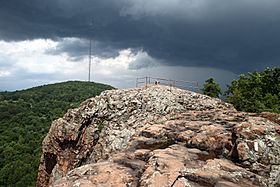
The summit of Pinnacle Rock, with Rattlesnake Mountain in the distance
|
|
| Highest point | |
| Elevation | 600 ft (180 m) |
| Parent peak | 41° 41' 23"N, 72° 49' 58"W |
| Geography | |
| Location | Farmington and Plainville, Connecticut |
| Parent range | Metacomet Ridge |
| Geology | |
| Age of rock | 200 Ma |
| Mountain type | Fault-block; igneous |
| Climbing | |
| Easiest route | Metacomet Trail |
Pinnacle Rock is a mountain peak in Connecticut. It stands about 600 feet (183 meters) tall. You can find it about 10 miles (16 km) southwest of Hartford, Connecticut. The mountain is located in the towns of Farmington and Plainville.
Pinnacle Rock is part of the Metacomet Ridge. This is a long, narrow line of mountains that stretches from Long Island Sound all the way north to the Vermont border. People love to visit Pinnacle Rock for outdoor fun. It's known for its amazing views from the top. It also has special natural areas called microclimates and is a path for migrating birds of prey. The Metacomet Trail, a hiking path, goes right over Pinnacle Rock.
It's good to know that Pinnacle Rock is not the same as The Pinnacle. There are two other peaks in Connecticut with that name. They are also on the Metacomet Ridge, on Talcott Mountain and Higby Mountain.
Contents
About Pinnacle Rock
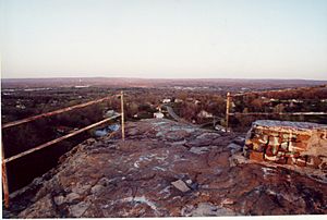
Pinnacle Rock is the highest point of a mountain ridge that is about 1 mile (1.6 km) long. It rises steeply about 400 feet (122 meters) above the valleys below. From the top, which is bare rock, you can see far out to the west. You can see the valleys, the town of Farmington, and even the Berkshire Mountains.
The Metacomet Ridge continues north from Pinnacle Rock to Rattlesnake Mountain. To the south, it becomes Bradley Mountain. A small river, the Quinnipiac River, flows through the gap between Pinnacle Rock and Bradley Mountain.
Water from the northeast side of Pinnacle Rock flows into Trout Brook. This brook then joins the Park River, which goes into the Connecticut River. Finally, it reaches Long Island Sound. The rest of the mountain feeds the start of the Quinnipiac River, which also flows directly into Long Island Sound.
A Look at the Rock's Past
From 1956 to 1961, there was a special defense site near Pinnacle Rock. It was called HA-67. This was a Nike 1B missile base. These missiles were used to defend against air attacks. The base was on the Plainville side of the rock, near Loon Lake.
Today, the base is no longer there. You can still see a parking lot and some old building parts that are now just rubble. Further southeast, there is a small quarry. A quarry is a place where rock is dug out of the ground.
How Pinnacle Rock Was Formed
Pinnacle Rock, like much of the Metacomet Ridge, is made of a type of rock called basalt. This rock is also known as traprock. Basalt is a volcanic rock. This means it came from volcanoes.
The mountain formed about 200 million years ago. This was near the end of the Triassic Period. At that time, the continents of North America, Africa, and Eurasia were pulling apart. Hot, melted rock, called lava, came up from deep inside the Earth. This lava cooled and hardened into thick layers of rock. Later, movements in the Earth's crust, like earthquakes, tilted these rock layers. This tilting created the steep cliffs and ridges you see at Pinnacle Rock today.
Nature and Wildlife at Pinnacle Rock
Pinnacle Rock has many different small natural areas. These are called microclimate ecosystems. They are created by the mountain's features. For example, the upper slopes are hot and dry. The ravines are cool and moist. The ledges have special mineral-rich rocks. This mix of environments allows for many different kinds of plants and animals to live there. Some of these species are rare in Connecticut.
Pinnacle Rock is also a very important path for raptor migration. Raptors are birds of prey, like hawks and eagles. They use the ridge as a guide when they fly south for the winter or north in the spring.
Fun and Protecting Pinnacle Rock
The Metacomet Trail runs across Pinnacle Rock. This trail is maintained by the Connecticut Forest and Park Association. It stretches from the Hanging Hills in Meriden, Connecticut all the way to the Massachusetts border.
On Pinnacle Rock, you can enjoy many outdoor activities. These include hiking, bird watching, picnicking, and snowshoeing.
The natural areas of Pinnacle Rock face threats from new buildings and from quarrying. In 2000, the National Park Service studied Pinnacle Rock. They were looking at including it in a new long-distance trail. This trail is now called the New England National Scenic Trail. It would connect the Metacomet-Monadnock Trail in Massachusetts with the Mattabesett Trail and Metacomet Trail in Connecticut.
 | Jackie Robinson |
 | Jack Johnson |
 | Althea Gibson |
 | Arthur Ashe |
 | Muhammad Ali |


