Rattlesnake Mountain (Connecticut) facts for kids
Quick facts for kids Rattlesnake Mountain |
|
|---|---|

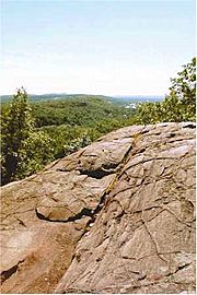
View from Rattlesnake Mountain
|
|
| Highest point | |
| Elevation | 750 ft (230 m) |
| Parent peak | 41° 41' 59"N, 72° 49' 58"W |
| Geography | |
| Location | Farmington, Connecticut |
| Parent range | Metacomet Ridge |
| Geology | |
| Age of rock | 200 Ma |
| Mountain type | Fault-block; igneous |
| Climbing | |
| Easiest route | Metacomet Trail |
Rattlesnake Mountain is a special kind of mountain called a traprock mountain. It stands about 750 feet (229 meters) above sea level. You can find it about 9 miles (14 km) southwest of Hartford, Connecticut, in the town of Farmington.
This mountain is part of a long, narrow chain of hills called the Metacomet Ridge. This ridge stretches all the way from Long Island Sound near New Haven, Connecticut, north through the Connecticut River valley into Massachusetts, and up to the Vermont border. Rattlesnake Mountain is a popular spot for outdoor fun near Hartford. People love its amazing views from the cliffs, its unique natural areas, and the rare plants that grow there. There's even a famous cave called Will Warren's Den on the mountain. The 51-mile (82 km) Metacomet Trail runs right over Rattlesnake Mountain.
Contents
Exploring Rattlesnake Mountain
Rattlesnake Mountain is about 1 mile (1.6 km) wide. It rises steeply about 500 feet (152 meters) above the Farmington River valley to its west. The mountain has a rounded top that slopes down into several ridges. These ridges connect it to Pinnacle Rock to the south and Farmington Mountain to the north.
On the northeast side of the mountain, there's a small quarry where they dig for traprock. On the southwest side, you'll find homes. Three tall broadcasting towers for TV stations (WTIC-TV, WHPX-TV, and WVIT-TV) stand on the very top of the mountain.
Water from the east side of Rattlesnake Mountain flows into Trout Brook, then to the Park River, and finally into the Connecticut River and Long Island Sound. Water from the west side goes into the Pequabuck River, then to the Farmington River, and also into the Connecticut River. The south side of the mountain is where the Quinnipiac River begins, which flows directly into Long Island Sound.
How the Mountain Formed and Its Nature
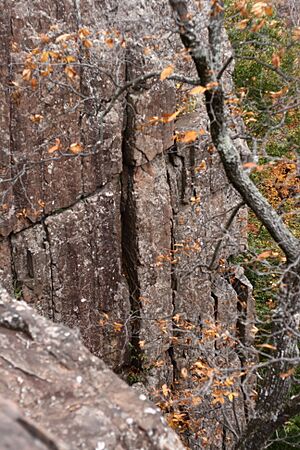
Rattlesnake Mountain, like much of the Metacomet Ridge, is made of a rock called basalt, also known as traprock. This rock came from volcanic activity. The mountain was formed about 200 million years ago, near the end of the Triassic Period. This was when the North American continent began to pull away from Africa and Eurasia. Hot lava flowed up from these cracks in the Earth and cooled, forming thick layers of rock. Later, faults (cracks in the Earth's crust) and earthquakes tilted these rock layers. This tilting created the steep cliffs and the ridgeline you see on Rattlesnake Mountain today.
The mountain has different types of environments, called microclimates. For example, some slopes are hot and dry, while ravines are cool and moist. The ledges are rich in minerals from the basalt rock. This mix of environments supports many plant and animal species that are rare in other parts of Connecticut. Rattlesnake Mountain is also an important path for raptors (birds of prey) when they migrate.
Local Stories: Will Warren's Den
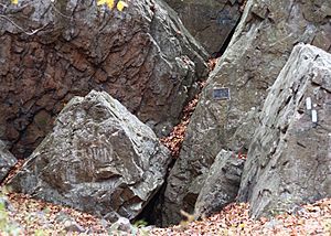
Will Warren's Den is a cave made of large boulders on the west side of Rattlesnake Mountain. It's a famous historical spot in Farmington. A sign at the cave tells a local story: "Legend says that Warren, after being punished for not going to church, tried to burn down the village of Farmington. He was chased into the mountains, where some Native American women hid him in this cave." You can reach the cave from the Metacomet Trail.
Fun Activities and Protecting the Mountain
The Metacomet Trail runs across Rattlesnake Mountain. This trail is cared for by the Connecticut Forest and Park Association. It stretches from the Hanging Hills in Meriden, Connecticut all the way to the Massachusetts border. From the top of Rattlesnake Mountain, you can enjoy many views looking west over the Pequabuck River valley towards the Berkshire Mountains. You can also see the town of Farmington below.
The mountain is a great place for hiking, bird watching, picnicking, snowshoeing, and other quiet outdoor activities. Some rock climbing websites even show different climbing routes on the mountain.
The biggest threats to Rattlesnake Mountain's natural environment are new buildings and quarrying (digging for rock). In 2000, the National Park Service studied Rattlesnake Mountain as part of a plan for a new National Scenic Trail. This new trail, now called the New England National Scenic Trail, would connect the Metacomet-Monadnock Trail in Massachusetts with the Mattabesett Trail and Metacomet Trail in Connecticut.
The Farmington Land Trust [1] works hard to protect Rattlesnake Mountain and its beautiful views. Will Warren's Den, which is part of the William S. Wadsworth Memorial property, is one of the many areas the trust helps manage.
 | Janet Taylor Pickett |
 | Synthia Saint James |
 | Howardena Pindell |
 | Faith Ringgold |


