Polk County, Minnesota facts for kids
Quick facts for kids
Polk County
|
|
|---|---|

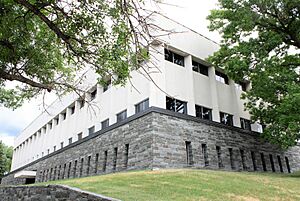
Polk County Government Center in Crookston
|
|

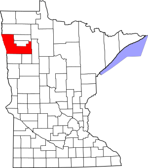
Location within the U.S. state of Minnesota
|
|
 Minnesota's location within the U.S. |
|
| Country | |
| State | |
| Founded | July 20, 1858 (created) 1872 (organized) |
| Named for | James Knox Polk |
| Seat | Crookston |
| Largest city | East Grand Forks |
| Area | |
| • Total | 1,997.791 sq mi (5,174.25 km2) |
| • Land | 1,970.999 sq mi (5,104.86 km2) |
| • Water | 26.792 sq mi (69.39 km2) 1.3%% |
| Population
(2020)
|
|
| • Total | 31,192 |
| • Estimate
(2023)
|
30,412 |
| • Density | 15.429/sq mi (5.957/km2) |
| Time zone | UTC−6 (Central) |
| • Summer (DST) | UTC−5 (CDT) |
| Congressional district | 7th |
Polk County is a county in the northwestern part of the U.S. state of Minnesota. It's known for its wide-open spaces and farming. The county was home to 31,192 people in 2020. Its main town, or county seat, is Crookston. The biggest community is East Grand Forks. Polk County is also part of the larger Grand Forks, ND-MN area.
Contents
History of Polk County
Polk County was created on July 20, 1858, by the Minnesota Legislature. This was one of the first things the state did after it was formed. However, the county wasn't fully set up until later.
The county got its name from James Knox Polk. He was the 11th president of the United States. President Polk signed the law that officially created the Minnesota Territory. Polk County was fully organized in 1872 and 1873. The town of Crookston, which was new at the time, became the county seat.
Geography and Nature
Polk County is located right on Minnesota's border with North Dakota. The Red River forms this border. The Red Lake River flows through the middle of the county, heading west. It eventually joins the Red River near Grand Forks.
The land in Polk County has gentle, rolling hills. Most of this land is used for farming. The county's highest point is in its southeast corner. It is about 1,519 feet (463 meters) above sea level. The county generally slopes down towards the west and north.
Transportation and Roads
You can get around Polk County using different ways.
- Tri-Valley Opportunity Council (T.H.E. Bus) offers public transportation.
Major Highways in Polk County
 U.S. Highway 2
 U.S. Highway 59
 U.S. Highway 75
 Minnesota State Highway 9
 Minnesota State Highway 32
 Minnesota State Highway 92
 Minnesota State Highway 102
 Minnesota State Highway 220
 Polk County State-Aid Highway 21: This road connects Grand Forks to Pennington County.
 Polk County State-Aid Highway 9: This is an important road between Crookston and the south part of Grand Forks.
 Polk County State-Aid Highways 11 & 46: These roads help trucks bypass Crookston.
 Polk County State-Aid Highway 2: This road is designed for heavy truck traffic. It connects US 2 to Roseau County and Marshall County.
Neighboring Counties
- Marshall County (north)
- Pennington County (northeast)
- Red Lake County (northeast)
- Clearwater County (east)
- Mahnomen County (southeast)
- Norman County (south)
- Traill County, North Dakota (southwest)
- Grand Forks County, North Dakota (west)
Protected Natural Areas
Polk County has many special places where nature is protected. These areas help keep plants and animals safe.
- Agassiz Dunes Scientific and Natural Area (part)
- Belgium State Wildlife Management Area
- Brandsvold State Wildlife Management Area
- Castor State Wildlife Management Area
- Enerson State Wildlife Management Area
- Erskine State Wildlife Management Area
- Glacial Ridge National Wildlife Refuge
- Gully Fen Scientific and Natural Area
- Hangaard State Wildlife Management Area
- Hasselton State Wildlife Management Area (part)
- Hill River State Wildlife Management Area
- Kroening State Wildlife Management Area
- Lavoi State Wildlife Management Area
- Lessor State Wildlife Management Area
- Mahgre State Wildlife Management Area
- Malmberg Prairie Scientific and Natural Area
- Pembina State Wildlife Management Area
- Polk State Wildlife Management Area
- Red River State Recreation Area (part)
- Red River Valley Natural History Area
- Rindahl State Wildlife Management Area
- Rydell National Wildlife Refuge
- Sand Hill Recreation Area
- Shypoke State Wildlife Management Area
- Stipa State Wildlife Management Area
People Who Live Here
| Historical population | |||
|---|---|---|---|
| Census | Pop. | %± | |
| 1860 | 240 | — | |
| 1880 | 11,433 | — | |
| 1890 | 30,192 | 164.1% | |
| 1900 | 35,429 | 17.3% | |
| 1910 | 36,001 | 1.6% | |
| 1920 | 37,090 | 3.0% | |
| 1930 | 36,019 | −2.9% | |
| 1940 | 37,734 | 4.8% | |
| 1950 | 35,900 | −4.9% | |
| 1960 | 36,182 | 0.8% | |
| 1970 | 34,435 | −4.8% | |
| 1980 | 34,844 | 1.2% | |
| 1990 | 32,498 | −6.7% | |
| 2000 | 31,369 | −3.5% | |
| 2010 | 31,600 | 0.7% | |
| 2020 | 31,192 | −1.3% | |
| 2023 (est.) | 30,412 | −3.8% | |
| U.S. Decennial Census 1790–1960 1900–1990 1990–2000 2010–2020 |
|||
In early 2024, the average value of a home in Polk County was about $216,560. There were about 12,472 homes, with an average of 2.39 people living in each. The average yearly income for a household was around $69,540.
About 11.6% of the people in the county live below the poverty line. About 64.9% of the population has a job. Most adults, about 93.4%, have a high school diploma. Also, 26.7% have a college degree or higher.
Most people in Polk County reported their background as English (92.8%). Other backgrounds include Spanish (2.7%), Indo-European (2.3%), and Asian and Pacific Islander (0.5%). The average age of people in the county was 39.3 years old.
Population in 2020
According to the 2020 census, Polk County had 31,192 people. There were 12,534 households and 7,852 families. The county had about 15.8 people per square mile.
Most people in the county, about 87.29%, were White. Other groups included African American (3.13%), Native American (1.46%), and Asian (0.50%). About 6.41% of the population were Hispanic or Latino.
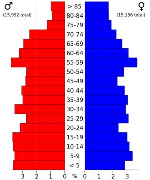
About 24.3% of residents were under 18 years old. About 5.8% were under 5 years old. And 19.8% of the people were 65 years old or older.
Communities in Polk County
Polk County has several cities and smaller communities.
Cities
Unincorporated Communities
These are smaller places that are not officially cities.
Townships
Townships are local government areas, often covering rural land.
- Andover Township
- Angus Township
- Badger Township
- Belgium Township
- Brandsvold Township
- Brandt Township
- Brislet Township
- Bygland Township
- Chester Township
- Columbia Township
- Crookston Township
- Eden Township
- Esther Township
- Euclid Township
- Fairfax Township
- Fanny Township
- Farley Township
- Fisher Township
- Garden Township
- Garfield Township
- Gentilly Township
- Godfrey Township
- Grand Forks Township
- Grove Park-Tilden Township
- Gully Township
- Hammond Township
- Helgeland Township
- Higdem Township
- Hill River Township
- Hubbard Township
- Huntsville Township
- Johnson Township
- Kertsonville Township
- Keystone Township
- King Township
- Knute Township
- Lessor Township
- Liberty Township
- Lowell Township
- Nesbit Township
- Northland Township
- Onstad Township
- Parnell Township
- Queen Township
- Reis Township
- Rhinehart Township
- Roome Township
- Rosebud Township
- Russia Township
- Sandsville Township
- Scandia Township
- Sletten Township
- Sullivan Township
- Tabor Township
- Tynsid Township
- Vineland Township
- Winger Township
- Woodside Township
See also
 In Spanish: Condado de Polk (Minnesota) para niños
 | Aaron Henry |
 | T. R. M. Howard |
 | Jesse Jackson |


