River Calder, West Yorkshire facts for kids
Quick facts for kids Calder |
|
|---|---|

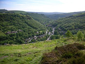
View of the Calder Valley west of Hebden Bridge
|
|
| Country | England |
| Metropolitan County | West Yorkshire |
| Towns/Cities | Todmorden, Hebden Bridge, Sowerby Bridge, Elland, Brighouse, Mirfield, Dewsbury, Wakefield |
| Physical characteristics | |
| Main source | Heald Moor between Holme Chapel and Cornholme, Lancashire 1,312 ft (400 m) |
| River mouth | River Aire, Castleford |
| Length | 45 mi (72 km) |
The River Calder is a river in West Yorkshire, Northern England. It starts on Heald Moor in Lancashire, near another river with the same name. The Calder then flows east through beautiful countryside, old mill towns, and villages in West Yorkshire. It eventually joins the River Aire near Castleford.
The area around the river is often called the Calder Valley. The name Calderdale usually refers to the large area around Halifax where the upper part of the river flows. The lower parts of the river flow through areas like Kirklees and Wakefield. While the Calder doesn't go through the centers of Halifax or Huddersfield, it does flow through Brighouse, Mirfield, Dewsbury, and the city of Wakefield.
Parts of the river can be used by boats, but these sections are connected by man-made channels called "cuts." These cuts, like Horbury Cut, form the Calder and Hebble Navigation. This is a popular waterway for fun activities and is part of England and Wales's connected inland waterway system.
Contents
What's in a Name?
The name "Calder" comes from an old language called Common Brittonic. Most experts agree it means something like "hard water" or "river of stones." This might be because the riverbed is rocky, or because its currents can be strong.
The name "Calder" is quite common in Northern Britain. You can find it in places across Lancashire and Yorkshire, and even in Scotland. For example, there's a Clan Calder in Scotland.
Where the River Flows
The River Calder starts high up, about 1,300 feet (400 m) above sea level, at Heald Moor, near Todmorden. It collects water from an area of about 369 square miles (957 km2). The river travels for about 45 miles (72 km) through many towns. These include Cornholme, Todmorden, Hebden Bridge, Sowerby Bridge, Elland, Brighouse, Mirfield, Dewsbury, and Wakefield.
Along its journey, other smaller rivers join the Calder. For example, Hebden Water joins at Hebden Bridge, and the River Ryburn joins at Sowerby Bridge. The Calder is also connected to the town of Rochdale across the Pennines mountains by the Rochdale Canal.
For much of its length, the Calder has been changed to allow boats to travel on it. This part is known as the Calder and Hebble Navigation. It's also part of the Aire and Calder Navigation. East of Castleford, the Calder flows into the River Aire, which then goes on to the Humber Estuary and finally the North Sea.
River History
The River Calder was very important for the textile industry in this area, especially in the Yorkshire Heavy Woollen District. Many large mills were built along its banks. These mills made cloth and yarn. Towns like Dewsbury, Wakefield, Brighouse, Hebden Bridge, Sowerby Bridge, and Todmorden all had mills. Even today, some of these old mill buildings are still standing.
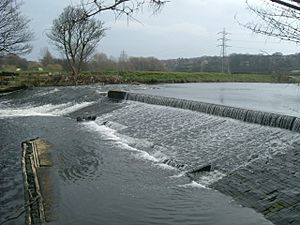
The river was a key way to transport raw materials and finished products from the mills. This was especially true before roads and railways were common. In many places, the river wasn't deep enough for boats or had weirs (small dams). So, special channels called "cuts" were made to allow boats to use the Calder and Hebble Navigation. Work to make the Calder navigable above Wakefield started in 1758.
Wakefield has a very old bridge with nine arches, built between 1342 and 1356. It replaced an older wooden bridge. There's even a small chapel on the bridge called the chantry chapel. Today, old mill buildings in Wakefield are being updated to create a new area called the Waterfront. This area has homes, offices, art galleries, and public spaces. The Hepworth Wakefield art gallery opened here in 2011.
In the 1830s and 1840s, the River Calder was moved at Kirkthorpe. This helped build the railway between Wakefield and Normanton. It also made a large curve in the river straight, which was cheaper than building many bridges. In recent years, new projects have used the river's power to create electricity. For example, a hydroelectric plant was built at Whalley Weir in 2015, and another at Kirkthorpe in 2017.
Filming Locations
The historic towns and cities in the Calder Valley have become popular places for filming movies and TV shows. Many productions have been filmed around Huddersfield. For instance, parts of the BBC show Happy Valley (2014) were filmed there. Some indoor scenes were shot at North Light Film Studios in Huddersfield.
Other shows like Jamaica Inn, Remember Me, and Black Work also used these studios. The BBC series Jericho (2016) filmed many outdoor scenes at Rockingstone Quarry nearby. The TV series The Gallows Pole, which is set in the 1760s, was partly filmed in Heptonstall.
River Wildlife and Pollution
Wildlife and Fish
A long time ago, the Calder River had many salmon. But pollution from factories and chemical plants in the 1800s caused the salmon to disappear. The last salmon was recorded in Wakefield in 1850. However, there are signs that salmon are returning, with sightings near Castleford in 2008.
Today, areas around Huddersfield, Mirfield, and Wakefield are popular for fishing. You can find fish like roach, perch, chub, dace, pike, bream, and trout. The river upstream of Dewsbury is getting cleaner. This means it's becoming a better home for fish like barbel and other types of coarse fish.
Along the river, there are four special areas called Sites of Special Scientific Interest. These areas protect important wildlife. As the river gets cleaner, native animals are returning. You might now see otters and kingfishers along parts of the river. Kingfishers are easy to spot all year round, especially around Mirfield.
Pollution
The river has been heavily polluted in the past. This was mainly due to the textile industry and, more recently, chemical factories along its banks. Near its source, the water was polluted by old mining sites and a landfill. This also caused a lot of soil to wash into the river.
As the river reached Huddersfield, the old textile factories created a lot of water pollution. This came from making synthetic dyes and cleaning wool. Also, the huge growth in population (over 800,000 people live in the river's area) caused problems with sewage. Another big source of pollution was an old tar factory in Mirfield.
In the 1950s, the river was so polluted by dye factories that it would change colors every day. After a long holiday weekend, the water would clear up. You could then see the river bottom, which looked like a grey wool blanket. Stricter rules in the 1950s helped improve water quality. Now, groups like Calder Future work with local businesses and Yorkshire Water to keep the river clean and bring back its wildlife.
Flooding and Defences
The River Calder has a history of flooding. This is often because the river banks are high in its upper parts. This causes rainwater to run off quickly into the river after heavy rain. Much of the lower river area has many buildings. This traps the flowing water in the river channels. Fast-moving water also picks up dirt and mud from the banks. This raises the river level even more.
Many flood defences have been built along the Calder Valley. These help prevent floods like the ones that caused a lot of damage earlier this century. For example, at Wakefield, the lake at Pugneys Country Park can hold extra river water. This helps protect the town.
The recently updated Wakefield Waterfront area has a very advanced flood defence system. This system uses computers to control automatic flood barriers. These barriers are hidden underground and rise up by themselves when there is a risk of flooding.
Fun on the River
The River Calder is a great place for many water activities:
- A canoeing centre is located at Sowerby Bridge.
- You can go waterskiing in gravel pits at Cromwell Bottom.
- Pugneys Country Park offers watersports and angling (fishing).
- People enjoy using leisure boats and narrowboats on the lower part of the river. It's easier to navigate here because of the canals built during the Industrial Revolution.
- You can also enjoy walking routes along the Pennine Way and Calderdale Way.
- Fishing is allowed in certain areas. You might need a special licence for some spots.
See also
 In Spanish: Río Calder para niños


