
Rock River (Mississippi River tributary) facts for kids
Quick facts for kids Rock River |
|
|---|---|

Drainage basin of the Rock River
|
|
| Country | United States |
| States | Wisconsin, Illinois |
| Physical characteristics | |
| Main source | Horicon Marsh north of Horicon, Wisconsin 43°28′26″N 88°38′41″W / 43.4738889°N 88.6447222°W |
| River mouth | Confluence with the Mississippi River at Rock Island, Illinois 551 ft (168 m) 41°28′57″N 90°36′58″W / 41.4825326°N 90.6162489°W |
| Length | 299 mi (481 km) |
| Basin features | |
| Progression | Rock River → Mississippi → Gulf of Mexico |
| GNIS ID | 416824 |
The Rock River is a long river in the United States. It flows through the states of Wisconsin and Illinois. It is about 299 miles (481 km) long. The Rock River is a "tributary" of the Mississippi River. This means it flows into the Mississippi River.
Long ago, the Sauk and Meskwaki tribes called this river the Sinnissippi. This name means "rocky waters."
Contents
Where the Rock River Begins
The Rock River starts with three separate parts. These parts flow into a large wetland called the Horicon Marsh.
The River's Branches
- The West Branch starts near the village of Brandon. It flows east and then south into Horicon Marsh.
- The South Branch begins north of Fox Lake. It flows east through Waupun to the marsh.
- The East Branch starts southeast of Allenton. It flows north and west through Theresa to the marsh.
The Rock River's Journey South
After leaving Horicon Marsh, the Rock River flows south. It crosses the border into Illinois. It ends about 300 miles later. It joins the Mississippi River near the Quad Cities in Illinois and Iowa.
Cities and Other Rivers Along the Way
As it flows, the Rock River passes through many towns.
- In Wisconsin, it goes through Watertown.
- It collects water from the Crawfish River in Jefferson.
- It also gets water from the Bark River at Fort Atkinson.
- The Rock and Crawfish rivers sometimes flood nearby land. This can even close lanes on Interstate 94.
In northern Rock County, Wisconsin, the Rock River gets water from the Yahara River. It then flows through Janesville and Beloit.
Entering Illinois
The river then enters northern Illinois.
- It receives the Pecatonica River about 5 miles (8 km) south of the state line.
- It flows south through Rockford.
- Then it turns southwest across northwestern Illinois.
- It picks up the Kishwaukee River.
- It passes through towns like Oregon, Dixon, Sterling, and Rock Falls.
- Sterling is home to the Sinnissippi Mounds, a historic site.
- Finally, the Rock River joins the Mississippi River at Rock Island.
Ronald Reagan's Connection
Did you know that Ronald Reagan, a former U.S. President, was a lifeguard on the Rock River in Dixon? His favorite fishing spot there is now called "Dutch Landing." "Dutch" was his nickname!
Dams on the Rock River
There are 25 dams built on the Rock River. These dams are located in various towns along its path.
- In Wisconsin, dams are in Theresa (3 dams), Waupun, Horicon, Mayville (2 dams), Kekoskee, Hustisford, Watertown (2 dams), Jefferson (4 dams), Indianford, Janesville, and Beloit.
- In Illinois, dams are in Rockton, Rockford Fordham, Oregon, Dixon, Sterling / Rock Falls (2 dams), Milan, and Rock Island.

Fun on the Rock River: Water Trail
The Rock River is a great place for water sports like paddling. The Rock River Water Trail is a special path for boats. It runs along the river for 330 miles (531 km). It starts at the river's beginning in Wisconsin. It ends where the river meets the Mississippi in Illinois and Iowa.
About the Water Trail
- The trail goes through five counties in Wisconsin.
- It also goes through six counties in Illinois.
- It passes through 37 different towns.
- The river moves slowly, making it good for paddling.
- You can see beautiful rural areas, wild places, and cities along the trail.
- The first two starting points for the trail are in Waupun, Wisconsin and Theresa, Wisconsin.
- There are 32 more places to get on the river in Dodge County, Wisconsin.
- This trail is part of the National Water Trails System. It's the first National Water Trail in both Wisconsin and Illinois!
Rock River Park
There's also a place called Rock River Park. It's near Johnson Creek, Wisconsin. This park offers a place to access the river. It also has a natural spring.

Cities and Villages Along the River
Here are some of the communities located along the Rock River, listed from north to south.
- Brandon, Wisconsin (West Branch)
- Waupun, Wisconsin (South Branch)
- Theresa, Wisconsin (East Branch)
- Mayville, Wisconsin (East Branch)
- Kekoskee, Wisconsin (East Branch)
- Horicon, Wisconsin
- Hustisford, Wisconsin
- Ixonia, Wisconsin
- Watertown, Wisconsin
- Johnson Creek, Wisconsin
- Jefferson, Wisconsin
- Fort Atkinson, Wisconsin
- Indianford, Wisconsin
- Fulton, Wisconsin
- Janesville, Wisconsin
- Afton, Wisconsin
- Beloit, Wisconsin
- South Beloit, Illinois
- Rockton, Illinois
- Roscoe, Illinois
- Machesney Park, Illinois
- Loves Park, Illinois
- Rockford, Illinois
- Byron, Illinois
- Oregon, Illinois
- Grand Detour, Illinois
- Dixon, Illinois
- Sterling, Illinois
- Rock Falls, Illinois
- Lyndon, Illinois
- Prophetstown, Illinois
- Erie, Illinois
- Hillsdale, Illinois
- Cleveland, Illinois
- Colona, Illinois
- Moline, Illinois
- Coal Valley, Illinois
- Milan, Illinois
- Rock Island, Illinois
Images for kids
-
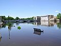
Rock River flooding downtown Fort Atkinson, June 2004
-

The frozen Rock River near Oregon, Illinois


