
San Salvador facts for kids
Quick facts for kids
San Salvador
|
|||
|---|---|---|---|
| San Salvador City | |||

Top, left to right: National Palace of El Salvador, Zona Rosa (San Salvador), Temple of El Salvador, Metropolitan Cathedral of San Salvador, Skyline of San Salvador, Zona Rosa and Cuscatlán Stadium
|
|||
|
|||
| Motto(s):
Nuestra Capital – 2011 Ibero-American Capital of Culture
|
|||

San Salvador
Location in El Salvador

San Salvador
Location in Central America

San Salvador
Location in North America
|
|||
| Country | El Salvador | ||
| Department | San Salvador | ||
| Metro | San Salvador Metropolitan Area | ||
| Founded | 1525 | ||
| Founded by | Pedro de Alvarado | ||
| Named for | Divine Savior placed on the Monument | ||
| Government | |||
| • Type | Mayor–council government | ||
| Area | |||
| • Capital city | 72.25 km2 (27.90 sq mi) | ||
| • Metro | 651.31 km2 (251.47 sq mi) | ||
| Elevation | 658 m (2,159 ft) | ||
| Population
(2024)
|
|||
| • Capital city | 525,990 | ||
| • Rank | 1st, El Salvador | ||
| • Density | 2,901.4/km2 (7,515/sq mi) | ||
| • Urban | 1,538,525 | ||
| • Metro | 2,177,432 | ||
| • Metro density | 3,343.16/km2 (8,658.7/sq mi) | ||
| Demonym(s) | Sansalvadoran Sansalvadoreño/a Capitalino/a |
||
| GDP (PPP, constant 2015 values) | |||
| • Year | 2023 | ||
| • Total (Metro) | $14.7 billion | ||
| • Per capita | $13,200 | ||
| Time zone | UTC−6 (Central Standard Time) | ||
| SV-SS |
CP 1101
|
||
| Area code(s) | + 503 | ||
| HDI (2018) | 0.704 − high | ||
| Website | sansalvador.gob.sv | ||
.svg)
.svg)
San Salvador is the capital and largest city of El Salvador. It is also the main city of the department with the same name. This city is the most important center for politics, culture, education, and money in the country.
The city of San Salvador itself has about 525,990 people (as of 2024). When you include the capital and 13 nearby towns, the Metropolitan Area of San Salvador has a population of about 2.4 million people.
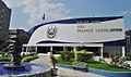
San Salvador is where the main government offices are located. These include the Council of Ministries, the Legislative Assembly of El Salvador, and the Supreme Court of El Salvador. The official home of the President of El Salvador is also here. The city sits in the highlands of El Salvador, surrounded by volcanoes. This means it can experience earthquakes.
The city has hosted many important events. These include the Central American and Caribbean Games in 1935, 2002, and 2023. It also hosted the Central American Games in 1977 and 1994. San Salvador was even home to the Miss Universe beauty pageant in 1975 and 2023. In 2008, it hosted the 18th Ibero-American Summit, a major meeting for Spanish and Portuguese-speaking countries. The main office for the Central American Integration System is also in San Salvador.
Contents
What's in a Name?
The name San Salvador was given by Gonzalo de Alvarado in 1525. It means "Holy Savior" and honors the Transfiguration of Jesus. This event is celebrated every year on August 6. In 1456, Pope Callixtus III made this day special to remember a big victory. Hungarian forces won against the Ottomans at the Siege of Belgrade.
This name also inspired the country's name, El Salvador, in 1824. San Salvador became the capital city way back in 1546, during Spanish rule.
A Look Back in Time
![]() Kingdom of Spain 1525–1821
Kingdom of Spain 1525–1821
![]() Mexican Empire 1822–1823
Mexican Empire 1822–1823
![]() Central America 1823–1841
Central America 1823–1841
![]() El Salvador 1841–1896
El Salvador 1841–1896
![]() Central America 1896–1898
Central America 1896–1898
![]() El Salvador 1898–present
El Salvador 1898–present
Before the Spanish arrived, the Pipil people had their capital city, Cuzcatlan, near where San Salvador is today. The Pipil people left Cuzcatlan to avoid Spanish rule. In 1525, Pedro de Alvarado sent his friends, Gonzalo de Alvarado and Diego de Holguín, to take over the empty city. Diego de Holguín became the first mayor of San Salvador.
The city moved twice, in 1528 and 1545. It was first built at a place now called Ciudad Vieja. It then moved to the Valle de Las Hamacas, which means "Valley of Hammocks." This name came from the many earthquakes that shake the area. The new spot was chosen because it had more space and fertile land near the Acelhuate River. The city stayed quite small until the 1900s.

In the late 1800s and early 1900s, new buildings were constructed. The Sara Zaldivar Asylum for the poor and elderly was built in 1885. In 1902, the Hospital Rosales opened, thanks to a banker named Jose Rosales. The National Palace began construction in 1905, paid for by taxes on coffee. Other important buildings like the Monumento a los Próceres de 1811 and the Teatro Nacional de El Salvador were built around 1911.
In 1917, an earthquake caused by the nearby San Salvador volcano damaged the city. Luckily, lava flowed away from the city. In 1931, a military coup removed President Arturo Araujo. Maximiliano Hernández Martínez became president and ruled until 1944.

From the 1960s to the 1980s, San Salvador saw a "golden age." It was a time of more safety, better quality of life, and modern changes. In 1964, José Napoleon Duarte was elected mayor. He built parks, updated the electrical grid, and started schools for adult education.
The Salvadoran Civil War began in the 1980s. This stopped many building projects. Some planned buildings, like a 40-story government building, were never finished.
In 1969, celebrations were held at the Estadio Cuscatlán for soldiers returning from the Football War with Honduras. The Boulevard de los Héroes was named after these soldiers. In 1986, a big earthquake hit San Salvador. It destroyed many buildings and caused hundreds of deaths and injuries. Thousands of people lost their homes.
The Chapultepec Peace Accords were signed on January 16, 1992. This ended 12 years of civil war. People celebrate this day as a national holiday in downtown San Salvador.
Since 2009, Mayor Norman Quijano has worked to improve the historic downtown. This includes moving street vendors to new markets.
Where is San Salvador?
The city is located in the Boquerón Volcano Valley. This area has a lot of earthquake activity. The city's average height is about 659 meters (2,159 feet) above sea level. However, some parts are higher (1,186 meters or 3,891 feet) and some are lower (596 meters or 1,955 feet).
Natural features surround the city. The Acelhuate River is to the east. San Jacinto Hill is to the southeast. El Picacho Mountain and Bicentennial Park are to the west. The San Antonio River is to the north. The Cordillera del Balsamo (Balsam Mountain Range) is to the south. The Boquerón Volcano and Cerro El Picacho are to the west. Cerro El Picacho is the highest point in the city area at 1,929 meters (6,329 feet).
The El Boquerón Volcano was quiet since 1917, but it has been active recently. To the east is San Jacinto Hill and the Lake Ilopango caldera. This lake is the largest natural body of water in El Salvador. It covers about 72 square kilometers (28 square miles). The lake area has earthquakes, but the lake itself has not erupted since 1880.
Weather in San Salvador

San Salvador has a tropical wet and dry climate. This means it is very warm or hot all year. The average daily temperature is about 27°C (81°F). Because the city is high up, it has slightly cooler mornings. It also gets more sunlight and bigger temperature changes during the day, especially in the dry season.
From November to February, the weather cools down due to dry season winds. The average daily temperature during these months is about 22.2°C (72°F). The hottest months are April and May, when the dry season changes to the rainy season. In April and May, average high temperatures reach 32.2°C (90°F).
The highest temperature ever recorded was 38.5°C (101.3°F). The lowest was 8.2°C (46.8°F). Thunderstorms happen almost every day during the rainy season. They usually occur in the afternoon and evening. By morning, the sky clears, and the days are sunny until the next afternoon storms.
| Climate data for San Salvador (Ilopango International Airport) 1991–2020, extremes 1957–present | |||||||||||||
|---|---|---|---|---|---|---|---|---|---|---|---|---|---|
| Month | Jan | Feb | Mar | Apr | May | Jun | Jul | Aug | Sep | Oct | Nov | Dec | Year |
| Record high °C (°F) | 36.0 (96.8) |
36.1 (97.0) |
37.2 (99.0) |
38.4 (101.1) |
36.7 (98.1) |
34.6 (94.3) |
34.5 (94.1) |
35.1 (95.2) |
33.3 (91.9) |
35.6 (96.1) |
35.3 (95.5) |
35.7 (96.3) |
38.4 (101.1) |
| Mean daily maximum °C (°F) | 31.3 (88.3) |
32.5 (90.5) |
33.2 (91.8) |
33.0 (91.4) |
31.3 (88.3) |
30.3 (86.5) |
30.8 (87.4) |
30.7 (87.3) |
29.8 (85.6) |
29.7 (85.5) |
30.1 (86.2) |
30.7 (87.3) |
31.1 (88.0) |
| Daily mean °C (°F) | 23.1 (73.6) |
23.9 (75.0) |
24.7 (76.5) |
25.4 (77.7) |
24.9 (76.8) |
24.3 (75.7) |
24.3 (75.7) |
24.2 (75.6) |
23.7 (74.7) |
23.6 (74.5) |
23.3 (73.9) |
23.1 (73.6) |
24.0 (75.2) |
| Mean daily minimum °C (°F) | 17.5 (63.5) |
18.1 (64.6) |
19.0 (66.2) |
20.4 (68.7) |
20.9 (69.6) |
20.5 (68.9) |
20.0 (68.0) |
20.1 (68.2) |
20.1 (68.2) |
19.9 (67.8) |
18.8 (65.8) |
17.9 (64.2) |
19.4 (66.9) |
| Record low °C (°F) | 11.9 (53.4) |
12.0 (53.6) |
13.0 (55.4) |
12.0 (53.6) |
12.0 (53.6) |
15.5 (59.9) |
13.5 (56.3) |
12.2 (54.0) |
15.0 (59.0) |
12.5 (54.5) |
11.1 (52.0) |
12.0 (53.6) |
11.1 (52.0) |
| Average rainfall mm (inches) | 1.7 (0.07) |
1.2 (0.05) |
10.7 (0.42) |
42.1 (1.66) |
192.8 (7.59) |
264.5 (10.41) |
302.1 (11.89) |
318.5 (12.54) |
331.9 (13.07) |
245.4 (9.66) |
65.0 (2.56) |
5.6 (0.22) |
1,781.3 (70.13) |
| Average rainy days (≥ 0.1 mm) | 1 | 1 | 1 | 5 | 13 | 20 | 20 | 20 | 20 | 16 | 4 | 2 | 123 |
| Average relative humidity (%) | 69 | 68 | 68 | 72 | 80 | 83 | 81 | 83 | 86 | 84 | 77 | 73 | 77.1 |
| Mean monthly sunshine hours | 301 | 277 | 294 | 243 | 220 | 174 | 239 | 257 | 180 | 211 | 267 | 294 | 2,957 |
| Source 1: Ministerio de Medio Ambiente y Recursos Naturales | |||||||||||||
| Source 2: Danish Meteorological Institute (precipitation days and sun 1931–1960), Meteo Climat (record highs and lows) | |||||||||||||
Hills and Mountains


San Salvador has many hills. The most famous is the Boquerón Volcano. It stands over the city at 1,893 meters (6,211 feet) above sea level.
The city also shares Cerro El Picacho with the nearby town of Mejicanos. This peak is 1,931 meters (6,335 feet) high.

Part of the Cordillera del Bálsamo (Balsam Mountain Range) is in the city area. Its average height is 1,030 meters (3,379 feet). This mountain range is named after the Myroxylon balsamum tree. This tree is known for its special resin, called Balsam of Peru. El Salvador is the main exporter of this resin.
El Cerro de San Jacinto (San Jacinto Hill) is on the eastern side of the city. Its top is at 1,153 meters (3,783 feet). This hill was once famous for a cable car and park, but they are now abandoned.
Water Around San Salvador

The nearest river is the Acelhuate, which is 2.2 kilometers (1.4 miles) long. It forms a natural border between San Salvador and Soyapango. In the past, the Acelhuate was a water source for the city. However, due to city growth, it is now polluted. San Salvador itself does not have any large bodies of water.
Lake Ilopango is the closest large lake. It is only a few minutes from the city center. This lake is the largest natural body of water in El Salvador, covering 72 square kilometers (28 square miles).
Who Lives in San Salvador?
Most people in San Salvador speak Spanish. English is becoming more common. This is partly due to American culture and many Salvadorans returning from the United States.
In 2007, a study showed that 72.3% of San Salvador's people are Mestizo (mixed heritage). About 25.8% are white, mostly with Spanish family roots.
In 2015, San Salvador's population was estimated at 257,754 people. The larger metropolitan area had about 1.7 million people.
Beliefs and Religions
| Religious background San Salvador | ||||
|---|---|---|---|---|
| Religion | Percent | |||
| Roman Catholic | 56.6% | |||
| Protestant | 28.3% | |||
| None | 11.4% | |||
| Mormon | 2.5% | |||
| Other | 1% | |||
| Jewish | 0.2% | |||
Most people in San Salvador are Roman Catholic. There is also a large group of Protestants, mainly Evangelicals. Some of the biggest Protestant churches are the Iglesia Cristiana Josue and the Tabernaculo Biblico Bautista, Amigos de Israel.
There are also members of the Church of Jesus Christ of Latter-day Saints. They opened the San Salvador El Salvador Temple in 2011.
Catholic traditions are important for holidays. Las Fiestas Agostinas (The August Festivals) honor Jesus Christ, the Patron saint of El Salvador. However, fewer people are Catholic now, so these events are becoming less common.
San Salvador also has a small Jewish community. Many Jewish people came to El Salvador during World War II. This was thanks to José Castellanos Contreras, a Salvadoran diplomat. He helped thousands of Jews escape the Nazis by giving them Salvadoran papers. The city also has a small community of Palestinians, mostly Christians who moved from Palestine in the late 1800s and early 1900s.
Culture and Arts
San Salvador has a rich Spanish history. Its historic center has unique architecture. Many old buildings were destroyed by earthquakes. Newer buildings mix different styles like Baroque and Eclectic. The National Palace, built in 1905, combines Gothic, Neoclassical, and Renaissance styles.
The National Theater is the oldest theater in Central America. Built in 1917, it has a French Renaissance style with Rococo and Art Nouveau details. It can seat 650 people. The dome inside has a mural by Carlos Cañas and a crystal chandelier.
San Salvador is home to the Museo de Arte de El Salvador (MARTE). This museum has art from the mid-1800s to today. It has shown works by famous artists like Picasso and Salvador Dalí. The Museo Nacional de Antropología (MUNA) shows exhibits on human settlements, farming, and trade. It helps Salvadorans learn about their culture.
In 2011, San Salvador was named a "Latin American capital of culture." The city government is working to restore the downtown area. This helps celebrate the city's past and its diverse culture.
City Symbols
The city's symbols are the Monumento al Divino Salvador del Mundo, its shield, flag, anthem, and staff of office. The shield, designed by José Mejía Vides, has blue and white fields like the national flag. It also shows an emerald necklace and the bell of the Church of La Merced. This bell represents the 1811 Independence Movement.
The flag was designed for the city government. The city's anthem was written by Carlos Bustamante (words) and Ciriaco de Jesús Alas (music).
The municipal staff shows figures from local history. These include a native Amerindian, the first mayor Diego de Olguín, and important historical events.
In 2015, Mayor Nayib Bukele introduced a new city shield and flag. The new shield is silver, showing purity. It has the flag of El Salvador in the middle and the date 1834. This date marks when San Salvador became the capital of Central America. It also has two swords, representing past victories. A laurel crown and six stars, for the city's six districts, surround the shield.
Economy and Business
San Salvador is the main economic hub of El Salvador. About 70% of all public and private money invested in the country goes to the metropolitan area. The economy of San Salvador and nearby towns like Antiguo Cuscatlán and Santa Tecla is a mix of services, private education, banking, and manufacturing.
Other towns in the metropolitan area focus on industry, like Soyapango and Ilopango. Some focus on public services, like Mejicanos, or power generation, like Nejapa and Apopa. These towns also provide workers for industries in neighboring areas.
Since 2001, El Salvador has used the U.S. dollar as its currency. This was done to encourage foreign companies to invest in the country. San Salvador's economy mostly relies on money sent from abroad (remittances). After that, the service and retail sectors are most important, rather than heavy industry.
Money and Finance
San Salvador is home to most of the country's large companies. It supports many business activities. These include making food and drinks, medicines, and chemicals. It also involves selling cars, crafts, and building materials. Most national companies have their main offices in San Salvador. Many international companies also have regional offices here.
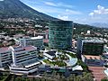
San Salvador does not have one main financial district. This is because city planning has been difficult since the civil war ended in 1992. However, many banks and phone companies are located along the Alameda Manuel Enrique Araujo. Business buildings and towers have also grown in the commercial areas of Colonia Escalón and Colonia San Benito.
World Trade Center San Salvador

The World Trade Center San Salvador is in District 3. It is connected to two hotels, a convention center, and a shopping center. The center has two towers with offices. Many international companies, embassies, and firms have offices here.
Centro Financiero Gigante

Centro Financiero Gigante is a group of five office towers. The tallest tower is 77 meters (253 feet) high and has 19 floors. This complex is one of the most important business areas in San Salvador. The tallest tower is used by the Telefónica phone company. Other companies like Tigo and Banco Azteca also have offices here.
Alameda Manuel Enrique Araujo and Zona Rosa

Along Alameda Manuel Enrique Araujo and Zona Rosa, you can find many businesses, banks, and government offices. These include the HSBC Central Office, the Ministry of Public Works, and the Centro Internacional de Feria y Convenciones (International Center of Fairs and Conventions). The Presidential Palace and the National Museum of Anthropology are also in this area.
Shopping and Services
San Salvador's economy is mostly based on the service sector. The city has many restaurants and shopping malls. Metrocentro is the largest shopping mall in Central America. You can also find big stores like Wal-Mart and Office Max. Centro Comercial Galerias, the tallest mall in the region, was built around an old mansion.
Industry in San Salvador
San Salvador has smaller industrial areas. Most of them are in the eastern part of the city, near Soyapango. A lot of the industry is about processing food, making drinks, and refining sugar. Building materials like ceramic tiles and concrete blocks are also made here. Making plastic pipes is another important industry.
Industrias La Constancia is El Salvador's largest company for brewing beer and bottling water. They are known for their Pilsener beer, which is the national beer of El Salvador. They also make Agua Cristal, the best-selling bottled water in Central America. The Coca-Cola company uses La Constancia's facilities to make its drinks for El Salvador and Central America.
Unilever also has a factory in San Salvador. They make foods, drinks, cleaning products, and personal care items. Unilever makes all its products sold in Central America in San Salvador.
Buildings and Design
Over time, earthquakes have destroyed many of San Salvador's old colonial buildings. Modern and Gothic style cathedrals have replaced them. During the Salvadoran civil war, many large building projects stopped. The 1986 San Salvador earthquake and the 2001 earthquakes also damaged many newer buildings.
Because of the earthquakes, building tall structures was difficult. But with new technology, earthquake-resistant structures are now possible. Today, San Salvador has many modern buildings, monuments, and stadiums. These buildings show different styles like Neo-Gothic, Modernist, and Futurist architecture.
Churches to Visit
- Iglesia El Carmen
- Iglesia El Rosario
- Iglesia El Calvario
Modern Buildings
- Centro Financiero Gigante
- Torre Roble
- Torre Terra Alta
- Torre Alisios 115
- Torre 515 Avenida La Capilla
- Torre 525 Avenida La Capilla
- Torres 105 Campestre
- Torre El Pedregal (Tallest tower in San Salvador City)
- Sheraton Presidente San Salvador Hotel
- Hilton Princess San Salvador Hotel
Unique Architectural Styles

- Palacio de los Deportes Carlos "El Famoso" Hernández (Stadium)
- Hospital Capilla Divina Providencia (Church where Oscar Romero was assassinated)
- Gimnasio Nacional José Adolfo Pineda
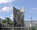
- Monumento al Divino Salvador del Mundo
- Monumento Hermano Bienvenido a Casa
- Lifestyle Center La Gran Via
- Multiplaza (El Salvador)
- Monumento a la Revolución (El Salvador)
- Monumento a La Constitución de El Salvador
- Ilopango International Airport
- Centro Internacional de Ferias y Convenciones (CIFCO)
- Estadio Jorge "Mágico" González
Futuristic Buildings

- Torre Futura
- Torre Cuscatlán
- Millenum plaza
- Edificio Insigne
- Edificio Avante
- El Salvador International Airport is being updated to a more futuristic style.
Fun Places to See
Historic Downtown Area

The historic downtown of San Salvador is where the capital city has been since the 1500s. Most of the original Spanish buildings were destroyed by natural disasters. The few old buildings that remain were built in the late 1800s and early 1900s. Mayor Norman Quijano has started projects to restore the beauty of these buildings. This includes changing bus routes and moving street vendors to new markets.
National Palace
.JPG)
The current National Palace was built between 1905 and 1911. It replaced an older palace that burned down in 1889. Money for the project came from a tax on exported coffee. Materials were brought from countries like Germany, Italy, and Belgium. Government offices used the palace until 1974.
The building has four main rooms and 101 smaller rooms. Each main room has a special color. The Red Room is used for foreign visitors. The Yellow Room was the President's office. The Pink Room held the Supreme Court. The Blue Room was where the Legislature of El Salvador met from 1906. It is now called the Salvadoran Parliament and is a National Historic Landmark.
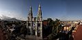
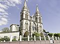
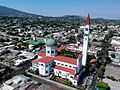
Metropolitan Cathedral

The Metropolitan Cathedral of the Holy Savior is the main church for Roman Catholics in San Salvador. Pope John Paul II visited it twice. He said the cathedral was "closely connected with the joys and hopes of the Salvadoran people." Many pilgrims visit the tomb of Archbishop Óscar Romero, who was killed in 1980.
In 1980, 44 people died during Archbishop Romero's funeral. This happened because of a crowd crush after some people fired guns. The square in front of the cathedral was also where people celebrated the end of the civil war in 1992. The cathedral was finished with a colorful tile mural by artist Fernando Llort in 1999. However, in 2012, the Archbishop ordered the mural to be removed.
National Theater

The Teatro Nacional de El Salvador is the oldest theater in Central America. It was designed by French architect Daniel Beylard and opened in 1917. The building has a French Renaissance style with modern touches. It can hold 650 people.
The theater has balconies on three levels, including a special Presidential Balcony. The dome inside has a mural by painter Carlos Cañas and a crystal chandelier. The theater is open to tourists. It is used for plays, shows, operas, and dance performances. It was declared a National Monument in 1979.
Calle Arce
Calle Arce is a main street in San Salvador. It is named after Manuel José Arce, the first president of the Federal Republic of Central America. The city has been working to improve this street. They are adding old Spanish lights, benches, and trees. Sidewalks are being updated with ramps for people with disabilities.
Parks and Plazas

Plaza Gerardo Barrios
La Plaza Gerardo Barrios is in the center of the city. A statue of President Gerardo Barrios stands there. It was made by Francisco Durini Cáseres and unveiled in 1909. The statue is made of bronze and shows battle scenes.
This plaza is a place for many public events and celebrations. It is a main spot for the feast of San Salvador on August 5 and 6. A religious parade called El Descenso ends here. It shows the resurrection of Jesus.
Plaza Libertad
Plaza Libertad has the Monumento de los Héroes (Monument to the Heroes). This monument celebrates 100 years since the "First Cry of Independence" in 1811. The monument has an "angel of freedom" at the top. Two fancy buildings, the Portal la Dalia and the Portal de Occidente, were built around the plaza.
Plaza Morazán
This plaza has a marble statue of Francisco Morazán. He was a former president of the Federal Republic of Central America. The statue was put up in 1882. March 15 is a national holiday to honor him.
Casa Dueñas

This important house was built in the 1920s. The government took it over in 1922. From 1935 to 1957, the United States ambassadors lived here. Famous guests like Richard Nixon and Clark Gable stayed here too. In 1986, it was declared a Cultural Asset. Restoration work began in 2001.
Convention Centers

The Centro Internacional de Ferias y Convenciones (CIFCO) is a large convention center. It is about 5 kilometers (3 miles) from the Historic Downtown. It is the largest and most modern convention center in Central America.
The CIFCO amphitheater is a major place for concerts and international artists. It can hold 15,000 people. Renovations from 2003 to 2010 added new halls and underground parking. CIFCO aims to help with international trade and tourism. Since 2021, a hospital for the COVID-19 pandemic has been built on the CIFCO grounds.
Museums to Explore
San Salvador has many museums. The largest are the Museo Nacional de Antropología de El Salvador (MUNA) and Museo de Arte de El Salvador (MARTE). MUNA helps Salvadorans understand their culture through exhibits and research. MARTE helps develop education and culture by showing art from the mid-1800s to today.
A fun museum for kids is the Tin Marín Museo de los Niños (Tin Marin Children's Museum). It is located near Gimnasio Nacional José Adolfo Pineda. Tin Marín helps children learn and be creative through fun exhibits. It has more than 25 exhibits, like "The Airplane" and "The Grocery Store."
Sports and Teams
Estadio Cuscatlán is the largest soccer stadium in Central America and the Caribbean. It can hold over 45,000 people. In 2007, it became the first stadium in the region to have a large LED screen. This screen lets fans watch the game better. The stadium was built in the early 1970s.
Another big stadium is the Estadio Jorge "Mágico" González. It can hold 35,000 people. This stadium hosted the Central American and Caribbean Games in 2002.

San Salvador is home to three major soccer teams: Alianza F.C., C.D. Atlético Marte, and C.D. Universidad de El Salvador. Alianza F.C. and Atlético Marte play at Estadio Cuscatlán. Alianza is known for its loyal fans and exciting game atmosphere.
Top Tourist Spots
- Catedral Metropolitana – Metropolitan Cathedral
- Teatro Nacional de El Salvador – The National Theatre of El Salvador
- National Palace (El Salvador) – The National Palace
- Monumento al Divino Salvador del Mundo – Monument to the Savior of the World
- Casa Presidencial – The Presidential Mansion
- Monumento a La Libertad – Monument to Liberty
- Estadio Cuscatlán – Soccer stadium
- Monumento a la Constitución – Constitution monument
- Plaza Alberto Masferrer
- Los Planes De Renderos – A place with many pupuserías (local food stalls), overlooking San Salvador.
Learning in San Salvador
San Salvador has many private high schools. These include Protestant, Catholic, and non-religious schools. The city also has many private schools where students learn in two languages.
Getting Around San Salvador
San Salvador is a major transportation center. It has a good public transport system. Main highways of the country pass through the city.
Airports Near San Salvador
The main airport for international flights is Monseñor Óscar Arnulfo Romero International Airport. It replaced Ilopango International Airport in 1980. Ilopango airport was too small to expand. The new airport was built outside the city, about 40 kilometers (25 miles) from San Salvador.
Monseñor Óscar Arnulfo Romero International Airport is on flat land. It is not surrounded by many people, so it can be expanded in the future. In 2008, it was the third busiest airport in Central America.

Ilopango International Airport is now used for military and charter flights. It was renovated and reopened in 2009. Ilopango also hosts an annual air show.
Roads and Highways

The main highway through San Salvador is the CA-1 (Pan-American highway). Another important road is the RN-21 (Bulevar Monseñor Romero). This road connects Santa Tecla and Antiguo Cuscatlán. It joins the RN-5 East/West (Bulevar los Próceres), which goes towards the International Airport. The RN-4 (Carretera Este Oeste) runs from San Salvador through Apopa.


In the city, roads running east-west are called "streets." Roads running north-south are called "avenues." Street numbers start at the intersection of Avenida Espana/Avenida Cuscatlán and Delgado Arce street.
A very busy road is 49a Avenida Norte. It connects to the highway to the airport. Some streets in the city are very narrow. Speed limits are 90 km/h (56 mph) on highways, 60 km/h (37 mph) on main roads, and 40 km/h (25 mph) on smaller streets.
SITRAMSS Bus System
The San Salvador Metropolitan Area Integrated System of Transportation (SITRAMSS) was a high-volume bus system. The first route went from San Martin, through Ilopango, Soyapango, San Salvador, and Antiguo Cuscatlan to Santa Tecla. Buses were planned to carry many passengers and run every eight to ten minutes.
Buses and Taxis

About 200,000 people use the city's public bus system every day. Some buses are run by the city, but most are private. This mix has caused some safety and traffic issues. Bus rides usually cost between $0.20 and $0.25. The city government runs a free bus system for people with disabilities, the elderly, and pregnant women. This is the only system like it in Central America.
Taxis operate throughout the city. Fares depend on the distance. Taxis in San Salvador are yellow, and most are Toyota Corollas.
Train Service
Train service was stopped in the 1990s. But it started again on October 1, 2007. Tickets cost $0.10. Trains depart from near the East Bus Station and travel to Apopa (service suspended from 2013). There are plans to open another route connecting northern San Salvador to Apopa and Nejapa.
There is also a historic train with refurbished cars from the 1960s. Once a month, visitors can ride this old train to experience how people traveled in the past.
Natural Disasters


San Salvador has been hit by many strong earthquakes. The worst one was in 1854. The San Salvador volcano erupted again in 1917. This caused three major earthquakes that damaged the city badly. The government had to move the capital temporarily to Santa Tecla.
The 1986 San Salvador earthquake hit on October 10, 1986. It caused a lot of damage. Between 1,000 and 1,500 people died, and over 10,000 were injured. About 200,000 people lost their homes.

The 2001 El Salvador earthquakes happened on January 13 and February 13, 2001. They caused much damage, especially in the Las Colinas area. A landslide there destroyed homes and killed many people.
During the 1980s, the Salvadoran civil war caused many people to move to the capital. Most of the fighting happened outside San Salvador.
Hurricanes, tsunamis, and landslides are also a threat. In November 2009, Hurricane Ida hit parts of El Salvador. It caused heavy rainfall and landslides. Many people lost their homes. The government opened schools as temporary shelters. Other countries sent aid to help.
Tropical Storm Agatha

Tropical Storm Agatha hit Central America on May 27, 2010. About 3 feet (1 meter) of rain fell in San Salvador over five days. This caused sinkholes, flash floods, and mudslides. Downtown, El Picacho, and Montebello were hit especially hard.
Tropical Storm Amanda

Tropical Storm Amanda brought very heavy rain to El Salvador. Rivers overflowed, sweeping away buildings. In San Salvador, 50 houses were destroyed, and 23 vehicles fell into a sinkhole. About 900 homes were damaged, and over 1,200 people had to leave their homes.
Movement rules for the COVID-19 pandemic in El Salvador were temporarily lifted. This allowed people to buy medicines and repair supplies. El Salvador's President Nayib Bukele declared a 15-day national emergency. Amanda was considered the worst weather disaster in El Salvador in 22 years. It caused more rain than Hurricane Mitch in many areas.
Famous People from San Salvador
- Arturo Ambrogi, writer and journalist
- Maribel Arrieta, Miss El Salvador 1955
- Nayib Bukele, president of El Salvador
- Alfredo Cristiani, former president of El Salvador
- José Castellanos Contreras, diplomat
- Armando Calderón Sol, former president of El Salvador
- Carlos Calleja, businessman
- Roque Dalton, poet and journalist
- Fernanfloo, YouTuber
- Fernando Llort, artist
- Milena Mayorga, ambassador and former model
- Alicia Nash, activist
- Ariane de Rothschild, CEO of Edmond de Rothschild Group
Images for kids
-
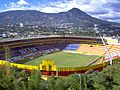
Cuscatlán Stadium
-
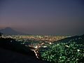
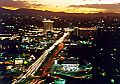
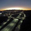
San Salvador night view
-
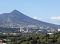
Northwest San Salvador
-
The Metropolitan Cathedral
-
Monument to the Revolution
-
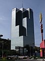
Apartment towers in San Salvador
-
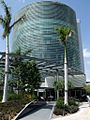
Torre Futura in the World Trade Center San Salvador
-
Boulevard De Los Héroes
-
Boulevard Monseñor Romero (Boulevard Diego de Holguin)
-
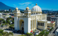
Metropolitan Cathedral of San Salvador
-
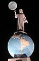
Monumento al Divino Salvador del Mundo
-
Torre Cuscatlan
-
Torre Futura, World Trade Center San Salvador
-
Legislative Assembly of El Salvador
-
Basilica Sagrado Corazon de Jesus
-
Iglesia El Carmen
-
Parroquia María Auxiliadora Don Rua
-
Iglesia El Calvario


Sister Cities
San Salvador has "sister city" relationships with these cities:
|
|
See also
 In Spanish: San Salvador para niños
