Sillajhuay facts for kids
Quick facts for kids Sillajhuay |
|
|---|---|
| Alto Toroni, Sillajguay | |

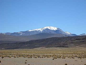
Sillajhuay seen from the west
|
|
| Highest point | |
| Elevation | 5,982 m (19,626 ft) |
| Prominence | 1,733 m (5,686 ft) |
| Parent peak | Nevado Sajama |
| Listing | Ultra, |
| Geography | |
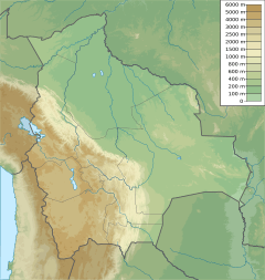
| Location | Bolivia–Chile border;Oruro, Arica y Parinacota |
| Parent range | Andes |
| Geology | |
| Age of rock | Pliocene-recent |
| Mountain type | Volcano |
| Volcanic arc/belt | Central Volcanic Zone |
| Climbing | |
| First ascent | pre columbian but first recorded ascent 1926 - Friedrich Adolf Ernest Ahlfeld (Germany) |
Sillajhuay (also called Sillajguay or Alto Toroni) is a volcano located right on the border between Bolivia and Chile. It is part of a long chain of volcanoes in the Andes mountains. This mountain has some ice on it, but it has been shrinking over the past few years.
Sillajhuay was formed on top of older volcanic rock. The volcano was active a very long time ago, about a million years ago. It has not erupted recently. However, the ground around it still moves a little, and there are small earthquakes. This suggests that magma might still be deep inside.
Contents
Where is Sillajhuay Located?
Sillajhuay is found in the Andes mountains. It sits on the border between Bolivia and Chile. Most of the mountain is in Chile, with only a small part in Bolivia.
This area is not very populated. The towns of Cancosa and Villa Blanca are about 16 to 18 kilometers away. A road also runs to the west of the volcano. The name "Sillajhuay" means "devil's chair" in the Aymara language. However, part of the name might also mean "llama."
Many volcanoes in the Central Volcanic Zone (CVZ) of the Andes are very tall, often over 5,000 meters high. Some of these volcanoes have erupted in recent history. For example, Lascar and Ubinas have been active. The biggest eruption in this area happened in 1600 at Huaynaputina.
How Tall is Sillajhuay?
Sillajhuay is usually said to be about 5,995 meters (19,669 feet) tall. Other measurements suggest it could be slightly taller or shorter, around 5,982 meters (19,626 feet). It is the highest peak in its local area.
Sillajhuay is part of a larger group of mountains. This group rises about 2,000 meters (6,562 feet) above the flat land around it. Other peaks nearby include Cerro Carvinto and Cerro Picavilque. The top part of the mountain group is hard to reach.
Because of past glaciation (when glaciers covered the land), the volcano's top has been worn down. You can't easily see a clear crater anymore. Below 4,100 meters (13,451 feet), you can see more clear signs of its volcanic past. The volcano once produced thick lava flows that traveled up to 14 kilometers (9 miles).
Ice on the Mountain
You can see patches of ice and snow on Sillajhuay, especially above 5,750 meters (18,865 feet). These patches are called firn and include tall snow formations known as penitentes. Some people consider this firn to be a small glacier. If so, it would be the southernmost glacier in the Andes before a very dry area.
However, this ice has been shrinking quickly. Between 1989 and 2011, the ice lost more than half of its surface area. It is expected to keep shrinking.
In the past, during the Late Quaternary period, Sillajhuay had much larger glaciers. There were about nine glaciers around the mountain. These old glaciers were up to 11 kilometers (7 miles) long. They left behind clear signs like glacial valleys and piles of rock called moraines. This shows that the mountain was covered by ice at least twice in the past.
Some slow-moving rivers of rock and ice, called rock glaciers, are also found on the southern side of Sillajhuay.
Water Around the Volcano
Steep valleys have been carved into the mountain by erosion. These include the Rio Blanco and Ricon Tacurma valleys. These valleys reach up to the summit and have rivers that flow all year. Other valleys have streams that only flow sometimes.
All the water flowing from Sillajhuay eventually goes east towards the Salar de Coipasa, a large salt flat. Long ago, there was a lake called the Cancosa paleolake south of Sillajhuay. There is also evidence that a landslide from Sillajhuay once blocked a river, creating a temporary body of water.
How Sillajhuay Formed
The Andes mountains, including Sillajhuay, were formed because of how Earth's plates move. The Nazca Plate and Antarctic Plate are sliding underneath the South America Plate. This process is called subduction. It causes volcanoes and hot springs to form in the Andes.
Volcanoes in the Andes are found in four main belts. Sillajhuay is in the Central Volcanic Zone (CVZ). These volcanic belts appear where the Nazca Plate slides steeply under the South America Plate.
Sillajhuay sits on top of older volcanic rocks called ignimbrites. These rocks were laid down on even older granite, sedimentary, and volcanic rocks. Over millions of years, large central volcanoes like Sillajhuay grew. The mountains were later shaped by at least two periods of glaciation.
What is Sillajhuay Made Of?
Sillajhuay is made of volcanic rocks called dacite and porphyry. Some of the porphyry contains sulfur, which gives it a yellow color. The rocks also contain crystals like plagioclase, biotite, hornblende, and quartz. Scientists study these rocks to understand how the magma formed deep inside the Earth.
Climate and Plants
Sillajhuay is in a very dry area with a mountain climate. It gets most of its rain during the summer. The amount of rain increases with height, from about 200 millimeters (8 inches) per year at 4,500 meters (14,764 feet) to 300-400 millimeters (12-16 inches) per year at 5,000 meters (16,404 feet). At night, temperatures can drop below -20 degrees Celsius (-4 degrees Fahrenheit).
The plants on the mountain are mostly grasses and shrubs, with a few rare trees. They grow mainly on the eastern side and can reach high elevations. One interesting plant found here is the yareta.
The dry climate is caused by a high-pressure system over the South Pacific Ocean. Also, the Humboldt Current off the coast cools the air and reduces moisture. Only during the summer do clouds bring moisture from the Bolivian Altiplano, causing most of the rainfall.
In the past, the climate was wetter and colder. This led to glaciers growing larger on Sillajhuay.
Human Activity on Sillajhuay
The summit of Sillajhuay can be climbed. There are Inca ruins on the very top, similar to other high-altitude Inca sites in the Andes. A Scottish climber named John Biggar discovered this site in 2013. The first recorded climb was in 1926 by Friedrich Adolf Ernest Ahlfeld from Germany.
Mining takes place east of Sillajhuay. There are sulfur mines in the area. People have also explored the possibility of using the heat from the Earth here to create geothermal power.
Has Sillajhuay Erupted Recently?
Scientists believe Sillajhuay is very old, forming during the Pliocene and Pleistocene periods. The fact that glaciers have heavily changed its shape suggests that its main volcanic activity happened a long time ago. Some studies suggest it was most active around 600,000 to 400,000 years ago.
However, between 2007 and 2010, the ground around Sillajhuay lifted by about 6 centimeters (2.4 inches). Small earthquakes have also been recorded at the volcano. There are also hot springs nearby. These signs suggest that magma might still be present deep under the volcano. Because of this, Sillajhuay is considered a potentially active volcano.
See also
 In Spanish: Cerro Sillajhuay para niños
- List of mountains in Chile
- List of Andean peaks with known pre-Columbian ascents
 | Emma Amos |
 | Edward Mitchell Bannister |
 | Larry D. Alexander |
 | Ernie Barnes |


