
Freehold Township, New Jersey facts for kids
Quick facts for kids
Freehold Township, New Jersey
|
||
|---|---|---|
|
Township
|
||
|
CentraState Medical Center
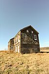
Walker-Combs-Hartshorne Farmstead
Jewish Heritage Museum
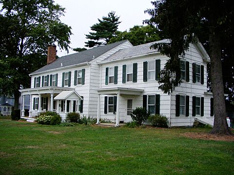
Craig House
Freehold Township High School
|
||
|
||
| Motto(s):
Western Monmouth's Family Town
|
||

Location of Freehold Township in Monmouth County highlighted in yellow (right). Inset map: Location of Monmouth County in New Jersey highlighted in black (left).
|
||

Census Bureau map of Freehold Township, New Jersey
<mapframe text="Interactive map of Freehold Township, New Jersey" latitude="40.23556305555556" longitude="-74.29498305555555" zoom="8" width="300" height="300"> { "type": "ExternalData", "service": "geoshape", "ids": "Q1077969" } </mapframe> |
||

Freehold Township, New Jersey
Location in Monmouth County, New Jersey

Freehold Township, New Jersey
Location in New Jersey

Freehold Township, New Jersey
Location in the United States
|
||
| Country | ||
| State | ||
| County | Monmouth | |
| Established | October 31, 1693 | |
| Incorporated | February 21, 1798 | |
| Named for | English legal term of freehold | |
| Government | ||
| • Type | Township | |
| • Body | Township Committee | |
| Area | ||
| • Total | 38.88 sq mi (100.71 km2) | |
| • Land | 38.65 sq mi (100.11 km2) | |
| • Water | 0.23 sq mi (0.59 km2) 0.59% | |
| Area rank | 59th of 565 in state 4th of 53 in county |
|
| Elevation | 118 ft (36 m) | |
| Population
(2020)
|
||
| • Total | 35,369 | |
| • Estimate
(2023)
|
35,531 | |
| • Rank | 67th of 565 in state 5th of 53 in county |
|
| • Density | 915.0/sq mi (353.3/km2) | |
| • Density rank | 393rd of 565 in state 46th of 53 in county |
|
| Time zone | UTC−05:00 (Eastern (EST)) | |
| • Summer (DST) | UTC−04:00 (Eastern (EDT)) | |
| ZIP Code |
07728
|
|
| Area code(s) | 732/848 and 908 (mobile) | |
| FIPS code | 3402525230 | |
| GNIS feature ID | 0882116 | |

.jpg)


Freehold Township is a community in Monmouth County, New Jersey. It's a busy area with major highways, making it a center for shopping and business in Central New Jersey. You'll find the Freehold Raceway and Freehold Raceway Mall here. Many people who live in Freehold Township also work in New York City, which is about 38 miles away. In 2020, about 35,369 people lived here.
Freehold Township was first created on October 31, 1693. It officially became a township on February 21, 1798. Over time, parts of Freehold Township were used to form other towns like Upper Freehold Township and Marlboro Township. The nearby Freehold Borough also formed from within the township and later became its own separate town.
A very important event in American history, the Battle of Monmouth, happened here in June 1778. Today, you can visit Monmouth Battlefield State Park to see where it took place.
Contents
- History of Freehold Township
- Geography of Freehold Township
- People of Freehold Township (Demographics)
- Economy of Freehold Township
- Sports in Freehold Township
- Parks and Recreation
- Education in Freehold Township
- Historic District
- Transportation in Freehold Township
- Healthcare
- Points of Interest
- Notable people
- See also
History of Freehold Township
Early Beginnings
Long ago, the Lenni Lenape Native Americans were the first people known to live in the Freehold area. They were hunter-gatherers, meaning they found their food by hunting small animals and birds, fishing, and gathering plants. They also grew some crops. Two important Lenape trails crossed paths right here in Freehold.
In 1498, John Cabot was the first European to see this land. By the late 1600s, the English started to take over. In 1685, people from Scotland and England, who were looking for religious freedom, settled here. In 1693, Freehold became one of the first three townships in Monmouth County. The name "Freehold" comes from an old English legal term about owning land completely.
Colonial Times
In 1714, Freehold was chosen as the county seat, which means it became the main town for the county government. A courthouse was built here in 1715. Soon, a small village grew around the courthouse. It was first called Monmouth Courthouse. Other government buildings, homes, and businesses like a blacksmith and a general store also appeared.
The farms around Monmouth Courthouse became very successful. They were known for growing potatoes, beans, and rye, which they sold in nearby cities. Freehold also became famous for its horse farms. By 1745, most families in Freehold were Scottish immigrants. Many streets today are named after these early families, like Barkalow and Applegate.

Revolutionary War Impact
The American Revolution greatly affected Freehold. In 1765, people in the area started groups like the Sons of Liberty to protest British rules. Freehold was a known center for those who supported American independence. The Declaration of Independence was even read aloud from the courthouse steps.
After a British victory in the Battle of Long Island, Freehold was controlled by people loyal to Britain. But the American victory at the Battle of Trenton helped weaken this control.
In June 1778, a huge battle happened in Freehold: the Battle of Monmouth. It was one of the biggest battles of the war, with over 25,000 soldiers. George Washington led the American forces. A famous person named Molly Pitcher also fought here, manning a cannon after her husband was hurt. Both sides claimed victory, but the Americans showed they could stand up to the British.


After the battle, the town was divided. Many people loyal to Britain left Freehold, fearing what their neighbors might do.
19th Century Growth
Freehold grew steadily in the 1800s. In 1852, a railroad station was built, bringing trains to the town. This helped Freehold's economy grow quickly. The village soon had public sewers, electricity, and telephones, which were very new inventions at the time. This made the village a busy center for business and industry. Farms also benefited by being able to sell their products more easily.
The American Hotel, which opened in 1824, is still standing today. In 1853, the Freehold Raceway opened. It's one of the oldest harness racetracks in America. In 1873, a big fire, known as the Great Fire of Freehold, burned down many buildings, including the Monmouth Courthouse.
Freehold also played a small part in bicycle history. A famous cyclist named Arthur Augustus Zimmerman lived here and even had his own bicycle company, Zimmerman Bicycle Co.
20th Century Changes
By the early 1900s, people in the downtown area and those on the farms in Freehold had different ideas about how to spend public money. This caused tension. In 1916, a serious illness spread through Freehold. After much debate, people voted to split the town into two separate areas.
On April 15, 1919, Freehold Borough officially separated from Freehold Township. The Borough kept the old government buildings and remained the county seat. Freehold Township, which was mostly farmland, set up its own town hall. The Township completely surrounds the Borough, like a donut around its hole!

After World War II, Freehold Township grew very fast. More people moved here because new highways like U.S. Route 9 and Route 33 made it easy to travel to jobs in bigger cities. Large neighborhoods of suburban homes were built. Big businesses also came to the township, like CentraState Medical Center (a hospital) and the Freehold Raceway Mall, which opened in 1990 and is one of the largest malls in New Jersey.
21st Century Life
Today, Freehold Township has many jobs and is still a place where people commute to nearby cities. The COVID-19 pandemic affected the township, like many communities. One family, the Fuscos, was greatly affected by the virus. The township also made it easier for restaurants to offer outdoor dining during this time.
Geography of Freehold Township
Freehold Township covers about 38.88 square miles. It's mostly land, with a small amount of water.
.png)
The township completely surrounds Freehold Borough. This is a special situation called a "doughnut town," where one town is completely inside another. Freehold Township borders several other towns in Monmouth County, like Colts Neck Township and Manalapan Township.
Some smaller communities within Freehold Township include East Freehold and West Freehold.
Waterways
Freehold Township is home to the starting points of many important rivers and streams in New Jersey. It sits on a ridge, with some parts having hilly terrain and rich soil, while southeastern parts are flatter and sandier.

The township is part of the larger Raritan Valley region and is also close to the Jersey Shore. A small part of the famous Pine Barrens reaches into the southern part of the township.
Lakes
- Lake Topanemus
- Turkey Swamp


Rivers and Streams
Many streams and brooks in Freehold Township flow into larger rivers like the Manasquan River and South River.
Climate
Freehold Township has a mix of two climates: humid subtropical and humid continental. This means it has warm, humid summers and cool to cold winters.
People of Freehold Township (Demographics)


In 2010, there were 36,184 people living in Freehold Township. Most people were White (84.32%), with smaller groups of Black or African American (5.34%) and Asian (7.03%) residents. About 7.76% of the population was Hispanic or Latino.
The average household had about 2.75 people, and the average family had 3.24 people. About 24.3% of the population was under 18 years old. The median age was 41.3 years.
Economy of Freehold Township
Freehold Township is an important economic center in Central Jersey. This is because it's a suburban area, close to the Jersey Shore, and near big cities like New York and Philadelphia.
Farming and Agriculture
Even though the township has grown a lot with suburban homes, its farming history is still important. You can find many types of farms here, including:
- Crop farms (for vegetables)
- Thoroughbred farms (for horses)
- Sod farms (for grass)
- Nurseries (for plants)
- Orchards (for fruit trees)
Some well-known farms are Brock Farms, Battleview Orchards, and Wemrock Orchards. Tomasello Winery also has a wine tasting room at Wemrock Orchards.


Shopping and Entertainment
Freehold Raceway, opened in 1853, is the oldest half-mile harness racing track in the country. It's a great place to watch horse racing.
The Freehold Raceway Mall opened in 1990. It's a very large shopping mall, one of the biggest in New Jersey, with many stores.

.jpg)


Besides the mall, Freehold Township has other shopping centers. iPlay America is a large indoor entertainment center that opened in 2011. It has rides, arcade games, laser tag, and restaurants, making it a fun place for families.
The nearby Freehold Borough has a downtown area with restaurants, shops, and historical sites.
Manufacturing
Freehold Township has also been a place for manufacturing. The Brockway Glass Company had a large facility here, which is now operated by Iron Mountain, a company that manages information. Nestle also had a production plant in the township until 2023, and 3M opened a magnetic tape factory here in 1957.
Sports in Freehold Township
Freehold Township has a strong history in youth baseball.
- In 2016, the Freehold Township Little League 12u baseball team won the New Jersey state championship.
- In 2017, the Freehold Township Little League 13U baseball team won the United States Championship in the Little League Intermediate World Series.
- In 2004, the Freehold Township Senior League baseball team won the Senior League World Series. This was the first time a team from Freehold Township won a World Series!
Parks and Recreation
.jpg)


Freehold Township has many parks, nature preserves, and trails for everyone to enjoy.
Monmouth Battlefield is a large state park that protects the historic battlefield where the American Revolutionary War's Battle of Monmouth took place. It has fields, woods, and wetlands, with miles of trails for hiking and horseback riding.
Turkey Swamp Park is a big county park and nature preserve with a lake. It has over 9 miles of trails, an archery range, playgrounds, and soccer fields. You can rent canoes, paddleboats, kayaks, and rowboats for the lake. In winter, you can even ice-skate! The park also has campgrounds. Next to it is the Turkey Swamp Wildlife Management Area, with more nature trails.
The Freehold Township Parks and Recreation Commission manages the local parks. They plan activities and keep the parks in good shape. They offer many sports programs like basketball, golf, and lacrosse. They also run a summer camp program for kids at Michael J. Tighe Park.
Freehold Township Online Registration Portal
Michael J. Tighe Park is the largest local park. It has many recreational options and was renamed in 2001 to honor a former recreation commissioner. Other local parks include Durand Park, Whittier Oaks Park, and Orchard Hills Park.
Lake Topanemus is a suburban park with a 71-acre lake. It's popular for fishing, paddle boating, and canoeing. It also has pretty nature trails, playgrounds, and open fields. Runners, walkers, and bikers use its crushed stone trails.
The Henry Hudson Trail starts in Freehold Borough and runs through the township. It's a great path for walking, running, and biking.
Education in Freehold Township
Students in Freehold Township from pre-kindergarten through eighth grade attend schools run by the Freehold Township Schools district. There are eight schools in the district, including:
- Early Childhood Learning Center (PreK)
- C. Richard Applegate Elementary School (K–5)
- Joseph J. Catena Elementary School (K–5)
- Laura Donovan Elementary School (K–5)
- Marshall W. Errickson Elementary School (K–5)
- West Freehold Elementary School (K–5)
- Clifton T. Barkalow Middle School (6–8)
- Dwight D. Eisenhower Middle School (6–8)
For high school, students attend either Freehold Township High School or Freehold High School. These schools are part of the Freehold Regional High School District, which also serves students from other nearby towns. Freehold Township High School has a special program called the Contemporary Global Studies Learning Center. Freehold High School has a Medical Sciences Learning Center. These programs accept students from all over the district.
High school students can also choose to attend special vocational schools in Monmouth County, like Biotechnology High School (located in Freehold Township), High Technology High School, or the Academy of Allied Health & Science. These schools offer specialized learning.
Brookdale Community College is a public college for Monmouth County. It has a location in Freehold Township on U.S. 9. High school students can even take college courses there to earn early college credits. Rutgers University and Seton Hall University also partner with Brookdale to offer degree programs at the Freehold campus.
Historic District
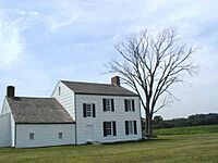
The Monmouth Battlefield Historic District is a historic area within the larger Monmouth Battlefield State Park. It's located on the border of Freehold Township and Manalapan Township.
This district preserves the site of the Battle of Monmouth. Many old farmhouses were once here, but only three from the time of the battle are still standing:
- The Sutfin Farmhouse (built 1731)
- The Rhea-Applegate House (built 1745)
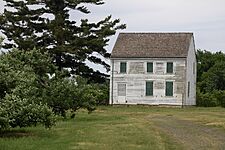
- The Craig House (built 1746)
The district was added to the National Register of Historic Places in 1966 because of its importance in military history and its old colonial buildings.
-
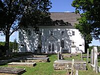
1753 Old Tennent Church
-
1746 Craig House
-
1872 Cobb House
-
Molly Pitcher Spring
-
1731 Sutfin House
-
1745 Rhea Applegate House
.JPG)


Transportation in Freehold Township
Roads and Highways
Freehold Township has many roads. As of 2010, there were over 200 miles of roadways. Major state roads include U.S. Route 9, Route 18, Route 33 (also called the Freehold Bypass), and Route 79. Several important county roads also pass through.
You can easily get to major highways like Interstate 195 and the Garden State Parkway from Freehold Township. The New Jersey Turnpike is also nearby.
_in_Freehold_Township,_Monmouth_County,_New_Jersey.jpg)
_at_the_exit_for_U.S._Route_9_SOUTH_(Lakewood)_in_Freehold_Township,_Monmouth_County,_New_Jersey.jpg)
Public Transportation
Trains
In the past, Freehold had two main railway lines. These helped make Freehold a transportation hub. Today, one of these old railway paths has been turned into the Henry Hudson Trail for walking and biking.
There's a plan called the Monmouth Ocean Middlesex Line to bring passenger train service back to the area, with Freehold Township possibly being a stop. For now, the closest train stations are on the North Jersey Coast Line (like in Aberdeen-Matawan) and the Northeast Corridor Line (like in New Brunswick).
Buses
NJ Transit provides bus service from Freehold Township to places like New York City, Newark, and Jersey City. There are also local bus routes for shopping. Freehold Township has special parking lots for residents who take the bus to commute.
Airports
For air travel, the closest small airports are Old Bridge Airport and Monmouth Executive Airport. For bigger commercial flights, the nearest major airports are Trenton-Mercer Airport and Newark Liberty International Airport.
Ferry
You can also take a ferry to New York City from Highlands, which is about a 25–30 minute drive from Freehold Township.
Healthcare

CentraState Medical Center is a large hospital located right in Freehold Township. It serves many parts of central New Jersey. It's connected with Rutgers Robert Wood Johnson Medical School. CentraState Healthcare System is one of the biggest employers in the county. Other hospitals nearby include Monmouth Medical Center Southern Campus and Raritan Bay Medical Center.
For more specialized care, major university hospitals are located in Neptune Township, Plainsboro Township, and New Brunswick.
Points of Interest
- CentraState Medical Center – A main hospital for the area.
- Freehold Raceway – One of the oldest horse racing tracks in the country.
- Freehold Raceway Mall – A very large shopping mall.
- Maplewood Cemetery – Where former New Jersey Governors and Civil War officers are buried.
- Monmouth Battlefield – A historic park where a major Revolutionary War battle was fought.
- Turkey Swamp Park – A large nature preserve with a lake and trails.
- Village of West Freehold – A historic village area.
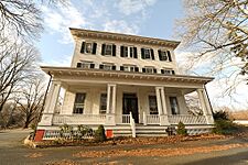
- Jewish Heritage Museum of Monmouth County – Shows the history of Jewish people and culture in the county.
-
Oakley Farmhouse, 2012
-
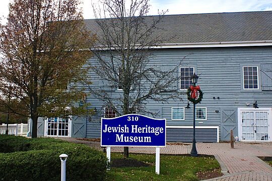
Jewish Heritage Museum at Mounts Corner, 2021

Notable people
Here are some well-known people who have lived in or are connected to Freehold Township:
- Amanda Anisimova (born 2001), professional tennis player
- Jake Areman (born 1996), soccer player
- Danny Bohn (born 1988), NASCAR driver
- Brad Brach (born 1986), professional baseball player
- Brian Brikowski (born 1989), football player
- Dave Cantin (born 1979), business person
- Danielle Colaprico (born 1992), soccer player
- Joe Dailey, American football coach
- Katie Dippold, comedy writer and actress
- Joann Downey (born 1966), attorney and former politician
- Clare Farragher (born 1941), former politician and mayor
- Michele Fitzgerald (born 1990), winner of Survivor: Kaô Rōng
- Lindsey Gallo (born 1981), former track and field athlete
- Milton Goode (born 1960), high jumper who competed in the Olympics
- Vin Gopal (born 1985), politician
- Robert Griswold (born 1996), swimmer
- Thomas Henderson (1743–1824), acting Governor of New Jersey
- William Barberie Howell (1865–1927), Chief Justice
- Robert Kolodny, film director
- Dan Lewis (1936–2015), American football player
- Caren Lissner (born 1972), novelist
- Paulie Litt (born 1995), actor and producer
- Val Majewski (born 1981), baseball player
- Catello Manzi (born 1950), harness racing driver
- Rebecca Metz, actress
- Joel Parker (1816–1888), former Governor of New Jersey
- Kal Penn (born 1977), actor
- Charles Richman, former government commissioner
- William Cortenus Schenck (1773–1821), founder of Newark, Ohio
- Peter Schrager (born 1982), sportscaster
- John A. Scudder (1759–1836), U.S. Representative
- Pamela Springsteen (born 1962), actress and sister of Bruce Springsteen
- Erik Stocklin (born 1982), actor
- Jaime Primak Sullivan (born c. 1977), reality television star
- John C. Ten Eyck (1814–1879), United States Senator
- William H. Vredenburgh (1840–1920), judge
- Emily Wold (born 1994), former field hockey player
See also
 In Spanish: Municipio de Freehold (Nueva Jersey) para niños
