West Freehold, New Jersey facts for kids
Quick facts for kids
West Freehold, New Jersey
|
|
|---|---|
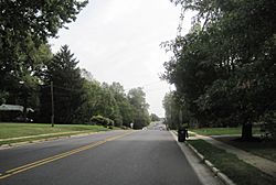
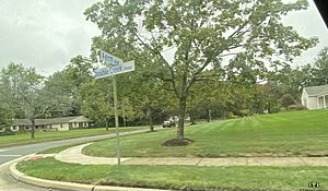
Along Schanck Road in the neighborhood of Stonehurst East
|
|
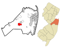
Map of West Freehold highlighted with in Monmouth County. Right: Location of Monmouth County in New Jersey.
|
|
| Country | |
| State | |
| County | Monmouth |
| Township | Freehold |
| Area | |
| • Total | 5.93 sq mi (15.35 km2) |
| • Land | 5.91 sq mi (15.31 km2) |
| • Water | 0.01 sq mi (0.04 km2) 0.24% |
| Elevation | 141 ft (43 m) |
| Population
(2020)
|
|
| • Total | 13,596 |
| • Density | 2,299.34/sq mi (887.76/km2) |
| Time zone | UTC−05:00 (Eastern (EST)) |
| • Summer (DST) | UTC−04:00 (Eastern (EDT)) |
| Area code(s) | 732/848 |
| FIPS code | 34-79100 |
| GNIS feature ID | 02390471 |
West Freehold is a community in Freehold Township, located in Monmouth County, New Jersey, United States. It is also known as a census-designated place (CDP), which means it's an area defined by the Census Bureau for statistics. In 2010, about 13,613 people lived here.
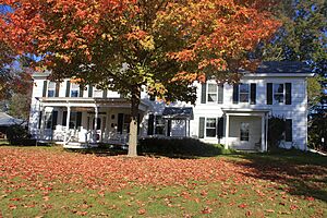
West Freehold is very close to the historic Battle of Monmouth site. Because of this, it has many important old buildings. These buildings are protected in the 'West Freehold Village Historic District'. Other historic places like Monmouth Battlefield, Clarksburg, Englishtown, Smithburg, and Tennent are also nearby.
Contents
History of West Freehold
New Jersey became a colony of England on June 24, 1664. This happened after the Duke of York gave land to Sir George Carteret and Lord John Berkely. This land is now New Jersey.
West Freehold was also known as 'Mount's Corner' a long time ago. People started settling here in the late 1600s. Many of them were English and Scottish Presbyterians, Baptists, and Quakers. They came to West Freehold to escape religious persecution in Scotland and New England.
The Burlington Path: An Old Road
A very important road in West Freehold was "The Burlington Path". This was a stagecoach route. It connected Burlington, which was the capital of West Jersey, with Perth Amboy, the capital of East Jersey. Today, much of Monmouth Road/West Main Street (County Route 537) follows the same path as this old stagecoach route. Many buildings from the colonial era are still standing in the 'West Freehold Village Historic District'. You can find them near the intersection of West Main Street and Stillwells Corner Road/Wemrock Road.
Moore's Tavern: A Historic Stop
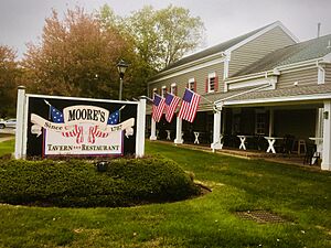
Today, this famous building is called Moore's Tavern & Restaurant. It was once a stagecoach stop on "The Burlington Path". Records show that the tavern's license was renewed in 1787. This means it was open even before that year! Moses Mount, a soldier who served with George Washington during the Revolutionary War, was the first person to run this inn.
The Levi Solomon Farmstead
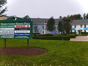
In its early days, Freehold Township was a safe place for religious groups who were being treated unfairly. The Solomon family was one of the first Jewish families to settle in New Jersey. They bought a large farm around 1720. This farm was located where the 'Mount's Corner' shopping center is today.
During the Battle of Monmouth, British soldiers damaged their home. Luckily, Hannah Solomon, who was a widow, and her two sons managed to save their house after it was set on fire. The original barn built on the farm in the 1800s is now the Monmouth County Jewish Heritage Museum. This museum teaches people about the Jewish history of the county.
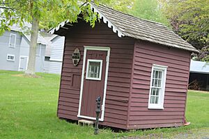
West Freehold Schoolhouse
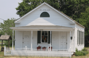
This old schoolhouse was built in 1848. It is located on Wemrock Road, next to West Main Street. Children in the community went to school here until 1937. The land where the school stands was once part of the Rulif R. Schanck Farmstead. Today, it is known as the Elizabeth Oakley Farm (Museum).
The Oakley Farmstead: Centuries of History
This farm has been in operation for hundreds of years. It is the oldest remaining farm in Freehold and one of the oldest preserved buildings in Monmouth County. It was settled in 1686. The farm covered 110 acres of land. It was owned by several families over time, including Barclay, Reid, Bowne, Clark, Walker, Combs, Schanck, Hartshorne, and Oakley.
By 1981, this farm was the largest working farm in Monmouth County. Elizabeth Oakley was the last person to live in the farmhouse. She loved its rich history and worked hard to save it. Her dream came true in 1990 when the farm was added to the National Register of Historic Places.
The Historic Toll House
There is a special Toll House on the Oakley Farmstead. It is one of only two toll houses left in New Jersey. It was built around 1850. A group of farmers who lived along "The Burlington Path" owned and ran it. The toll house separated two parts of the road. One side, heading southwest, was called the 'Freehold-Smithburg Turnpike'. The other side, heading northeast, went towards 'Elk's Point' (now Freehold Borough).
Community Life in West Freehold
West Freehold has many neighborhoods with different types of single-family homes. The two biggest neighborhoods are Stonehurst East and Stonehurst West. Homes in Stonehurst were mostly built in the 1960s and 1970s. They were built on large areas that used to be farmland.
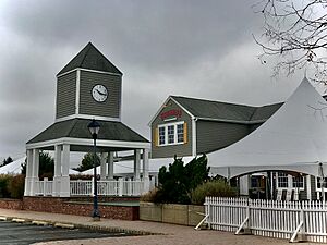
Raintree is a community with homes and shops. It is located near County Route 537. This gated community has nice condominiums built in the 1980s and 1990s. It also offers many things for its residents to enjoy. The Raintree Town Center is the main shopping area.
Geography of West Freehold
West Freehold covers about 5.93 square miles (15.35 square kilometers). Most of this area is land, with a very small amount of water.
Population and People
| Historical population | |||
|---|---|---|---|
| Census | Pop. | %± | |
| 1980 | 9,929 | — | |
| 1990 | 11,166 | 12.5% | |
| 2000 | 12,498 | 11.9% | |
| 2010 | 13,613 | 8.9% | |
| 2020 | 13,596 | −0.1% | |
| Population sources: 1980 1990–2010 2000 2010 |
|||
How Many People Live Here?
In 2010, the census counted 13,613 people living in West Freehold. There were 4,941 households, and 3,612 families. The population density was about 2,302 people per square mile.
Most people in West Freehold are White (87.06%). There are also Black or African American (3.17%), Asian (6.19%), and Native American (0.22%) residents. About 8.13% of the population is Hispanic or Latino.
About 25.1% of the people were under 18 years old. The average age was 41.4 years.
Transportation and Healthcare
Getting Around West Freehold
New Jersey Transit provides bus services in West Freehold. You can take local buses on route 307. There are also buses to Port Authority Bus Terminal in Midtown Manhattan (route 139). You can also get to Newark, Jersey City, and Hoboken areas on route 67.
Several major roads go through West Freehold. These include Monmouth Road/West Main Street (County Route 537), which has many businesses. Elton-Adelphia Road (County Route 524) is on the southern edge. U.S. Route 9 is on the eastern side and also has many businesses. New Jersey Route 79 is in the northeast corner. The New Jersey Route 33 freeway, called the "Freehold Bypass," is on the northern edge.
Healthcare Services
CentraState Medical Center is a hospital in West Freehold. It is connected with Rutgers Robert Wood Johnson Medical School. The hospital has 287 beds and is part of CentraState Healthcare System. It is one of the largest employers in the county. You can find it on West Main Street (County Route 537).
Nearby Historic Places
- Adelphia in Howell Township
- Clarksburg in Millstone Township
- Dayton in South Brunswick
- Jerseyville in Howell Township
- Lincroft in Middletown Township
- Marlboro in Marlboro Township
- Monmouth Battlefield Historic District in Freehold Township and Manalapan Township
- Monmouth Junction in South Brunswick
- Old Bridge in East Brunswick
- Perrineville in Millstone Township
- Plainsboro Center in Plainsboro Township
- Princeton Junction in West Windsor Township
- Tennent in Manalapan Township
- Wayside in Tinton Falls and Ocean Township
See also
 In Spanish: West Freehold para niños
 | William Lucy |
 | Charles Hayes |
 | Cleveland Robinson |


