Swabia Creek facts for kids
Quick facts for kids Swabia Creek |
|
|---|---|

Course of Swabia Creek
|
|
| Other name(s) | Swope Creek, Swabian Creek, Swamp Run |
| Country | United States |
| State | Pennsylvania |
| County | Lehigh, Berks |
| Physical characteristics | |
| Main source | Primary (west) branch Rittenhouse Gap 40°28′26″N 75°37′37″W / 40.4739852°N 75.6268548°W |
| 2nd source | East branch Hensingersville Dam 843 ft (257 m) 40°29′16″N 75°34′56″W / 40.487766°N 75.582127°W |
| 3rd source | Headwater of Mountain Creek Upper Milford Township 40°29′39″N 75°33′46″W / 40.4942°N 75.5628°W |
| River mouth | Little Lehigh Creek Macungie, Pennsylvania 351 ft (107 m) 40°32′09″N 75°32′19″W / 40.53584°N 75.53867°W |
| Basin features | |
| River system | Little Lehigh Creek |
| Basin size | 12.37 sq mi (32.0 km2) |
| Tributaries |
|
Swabia Creek is a stream in Pennsylvania, United States. It flows through Berks and Lehigh Counties. Swabia Creek is a smaller stream, also called a tributary, that flows into the Little Lehigh Creek. The creek is named after the "Swabia" region in Germany. Many early settlers in the area came from there.
Contents
Where Swabia Creek Flows
Starting Points
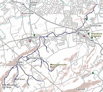
Swabia Creek has two main starting points, called branches. The west branch begins near the village of Red Lion. It meets another small stream in Maple Grove. The east branch flows through the Hensingersville Dam.
Joining Together
The west and east branches of Swabia Creek meet in Hensingersville. From there, the creek flows north towards Alburtis. It passes through Lock Ridge Park, which is a nice place to visit. The creek then turns east, running next to railroad tracks.
Through Macungie
As Swabia Creek continues, several small streams, which sometimes dry up, join it. These streams come from South Mountain. They flow past areas like "The Hills at Lock Ridge" and the Allen Organ Company headquarters. After these areas, Swabia Creek enters Macungie. In Macungie, a larger stream called Mountain Creek joins Swabia Creek.
Mountain Creek's Journey
Mountain Creek starts in Upper Milford Township, near a part of South Mountain known as "Macungie Mountain." It flows past a bird sanctuary called Reimert Memorial Bird Haven. Then, it goes through various natural springs that provide water to Macungie. Mountain Creek joins Swabia Creek in Kalmbach Park.
Final Stretch
After Mountain Creek joins, Swabia Creek turns northeast. Another small stream, Indian Creek, flows into Swabia Creek. This happens after Indian Creek passes some large petroleum storage tanks. Finally, Swabia Creek flows into the Little Lehigh Creek. Most of Swabia Creek's path is in Lower Macungie Township, Lehigh County. Some parts start in Berks County and Upper Milford Township.
Swabia Creek's Water Area
Swabia Creek has a drainage area of 12.37 square miles. This means it collects water from an area of about 12.37 square miles. The creek is part of a larger water system called the Lehigh River watershed. Mountain Creek is also part of the Swabia Creek watershed. Mountain Creek and the springs around it have historically supplied water to the town of Macungie.
Nature Around Swabia Creek
Rocks and Land
The land around Swabia Creek shows very old rocks. These rocks are found in places like South Mountain and Lock Ridge. They are mostly hard, ancient rocks like gneiss. As the creek flows, it passes over different types of rock. These include quartzite, which can have Skolithos fossils (ancient worm burrows). The creek also flows through areas with dolomite and limestone.
In the past, people mined for iron ore in the valleys and plains around Swabia Creek. Companies like the Thomas Iron Company operated many of these mines. There were also quarries for limestone and gneiss. Near Mountain Creek, Native Americans once quarried jasper, a type of rock. The soil in the flat areas near the creek is often made of fine silt.
Plants Along the Creek
Many important wetlands are found along Swabia Creek. These are areas where the land is wet, with forests, shrubs, or reeds. They are important for the environment. The Macungie watershed, where Mountain Creek flows, has special natural areas. These areas can support rare or endangered plants.
On South Mountain, common trees include tulip trees, sweet birches, and red oaks. You might also see silky dogwoods. Smaller plants like jewelweed, bulrush, and poison ivy grow underneath. In the flat areas along the creek, you can find native plants such as vervain, boneset, lobelia (including cardinal flowers), and asters. Other native plants include Joe-Pye weed, black eyed susans, and goldenrod. Some plants that are not native, like oxeye daisy, are also found. Invasive plants, such as Japanese knotweed and purple loosestrife, have been removed to help the native plants grow.
Animals in and Around the Creek
Swabia Creek is home to different kinds of fish. You can find brown trout, rainbow trout, catfish, and sunfish. Both Swabia Creek and Mountain Creek are considered "High Quality Cold Water Fisheries." This means their water is clean and cold enough for these fish to thrive.
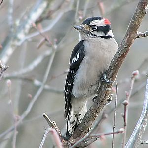
Many birds live permanently near the Mountain Creek headwater at Reimert Memorial Bird Haven. These include red-bellied woodpeckers, downy woodpeckers, and hairy woodpeckers. You might also see white-breasted nuthatches, black-capped chickadees, and tufted titmice. Other common birds are northern cardinals, blue jays, and house finches. Birds that migrate through the area include dark-eyed juncos, American robins, song sparrows, and mourning doves.
Protecting the Creek
In 2005, the Pennsylvania Department of Environmental Protection studied Swabia Creek. They found that pollution from farms and city runoff was harming the water quality. This pollution was also damaging the homes for aquatic animals and making the creek banks unstable. Because of this, Swabia Creek was put on a list of impaired waterways.
To fix these problems, experts suggested planting native plants along the creek. They also recommended using natural stream designs to improve the habitat. The department gave money to The Wildlands Conservancy. This group worked to make the stream and wetlands healthier.
The upper parts of Swabia Creek are in the Pennsylvania Highlands Region. This area is important for conservation. There are plans to create a "greenway" (a protected natural area) that would include much of the Swabia Creek watershed. The Macungie Watershed is considered an "Area of Statewide Significance" for conservation.
Macungie and Alburtis towns, along with Lower Macungie Township, are planning a 3-mile greenway and trail. This trail would run next to Swabia Creek from Alburtis to Macungie. There's also a plan for a path to extend from Macungie along Mountain Creek up to South Mountain.
History of the Area
When Europeans first arrived in this area, the Lenape people likely lived here. As the name suggests, many early European settlers came from the Swabia region of Germany. The area had a lot of iron ore, which attracted miners. Later, larger iron furnace companies came. The Catasauqua and Fogelsville Railroad was built mainly to carry this iron ore from the Swabian valley to the furnaces. An old inn in Maple Grove has been open since about 1783.
There is another stream called Schwaben Creek about 75 miles west of Swabia Creek. It is not related to this Swabia Creek.
What's in a Name?
Swabia Creek is also often called Swope Creek. The United States Geological Survey officially named it "Swabia Creek." However, they also recognize "Swabian Creek," "Swamp Run," and "Swope Creek" as other names for it. Both "Swabia Creek" and "Swope Creek" come from the fact that many early settlers were from the Swabia region in Germany. "Swope" and "Swabian" mean the same thing. In Bavaria, "Swope" or "Swab" means a person from Swabia. The name "Swope" comes from the German spelling, Schwaben, and even older Latin names for a German tribe called the Suebi.
 | Victor J. Glover |
 | Yvonne Cagle |
 | Jeanette Epps |
 | Bernard A. Harris Jr. |


