Tioga County, New York facts for kids
Quick facts for kids
Tioga County
|
|||
|---|---|---|---|

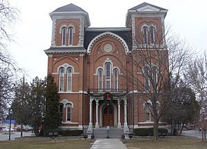
Tioga County Courthouse
|
|||
|
|||

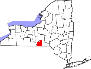
Location within the U.S. state of New York
|
|||
 New York's location within the U.S. |
|||
| Country | |||
| State | |||
| Founded | 1791 | ||
| Seat | Owego | ||
| Largest village | Waverly | ||
| Area | |||
| • Total | 523 sq mi (1,350 km2) | ||
| • Land | 519 sq mi (1,340 km2) | ||
| • Water | 4.3 sq mi (11 km2) 0.8% | ||
| Population
(2020)
|
|||
| • Total | 48,455 | ||
| • Density | 93.4/sq mi (36.1/km2) | ||
| Time zone | UTC−5 (Eastern) | ||
| • Summer (DST) | UTC−4 (EDT) | ||
| Congressional districts | 22nd, 23rd | ||
Tioga County is a county in the state of New York. In 2020, about 48,455 people lived here. The main town, or county seat, is Owego. Tioga County is part of the larger Binghamton metropolitan area. It is also part of the Southern Tier region of New York.
The name "Tioga" comes from an Iroquois word, De-yoh-ho-gah. This means "at the forks" or "where it forks." This likely refers to where rivers or paths meet.
Contents
History of Tioga County
Tioga County has a long history, starting when more people moved into the area. Before Tioga County was formed, this land was part of a much larger area called Montgomery County.
In 1789, Montgomery County was made smaller. A new area called Ontario County was created from some of its land. This new Ontario County was huge! It included many parts of what are now other counties in New York.
Then, in 1791, Tioga County was officially created. This happened when Montgomery County was divided again. At first, Tioga County was also much bigger than it is today. It included areas that are now Broome and Chemung counties. It also included parts of Chenango and Schuyler counties.
Over the years, Tioga County became smaller as new counties were formed. In 1798, Chemung County was created from part of Tioga County. Also, parts of Tioga and Herkimer counties were combined to form Chenango County. In 1806, Broome County was also created from Tioga County's land.
Geography of Tioga County
Tioga County is located in the southwest part of New York State. It is west of the city of Binghamton. It is also directly north of the border with Pennsylvania. The Susquehanna River flows through the county and then into Pennsylvania. This area is known as the Southern Tier region of New York.
The county covers about 523 square miles. Most of this area, about 519 square miles, is land. The rest, about 4.3 square miles, is water.
The highest point in Tioga County is a hill in the northern part. It is about 1,994 feet high. The lowest point is about 720 feet high. This is where the Susquehanna River crosses the state line into Pennsylvania.
Neighboring Counties
Tioga County shares borders with several other counties:
- Cortland County - to the northeast
- Broome County - to the east
- Susquehanna County, Pennsylvania - to the southeast
- Bradford County, Pennsylvania - to the south
- Chemung County - to the west
- Tompkins County - to the northwest
Main Roads
Several important roads run through Tioga County:


 I-86 / NY 17 / Southern Tier Expressway
 US 220
- New York State Route 17C
- New York State Route 38
- New York State Route 96
- New York State Route 96B
Population and People
| Historical population | |||
|---|---|---|---|
| Census | Pop. | %± | |
| 1800 | 7,109 | — | |
| 1810 | 7,899 | 11.1% | |
| 1820 | 16,971 | 114.8% | |
| 1830 | 27,690 | 63.2% | |
| 1840 | 20,527 | −25.9% | |
| 1850 | 24,880 | 21.2% | |
| 1860 | 28,748 | 15.5% | |
| 1870 | 30,572 | 6.3% | |
| 1880 | 32,673 | 6.9% | |
| 1890 | 29,935 | −8.4% | |
| 1900 | 27,951 | −6.6% | |
| 1910 | 25,624 | −8.3% | |
| 1920 | 24,212 | −5.5% | |
| 1930 | 25,480 | 5.2% | |
| 1940 | 27,072 | 6.2% | |
| 1950 | 30,166 | 11.4% | |
| 1960 | 37,802 | 25.3% | |
| 1970 | 46,513 | 23.0% | |
| 1980 | 49,812 | 7.1% | |
| 1990 | 52,337 | 5.1% | |
| 2000 | 51,784 | −1.1% | |
| 2010 | 51,125 | −1.3% | |
| 2020 | 48,455 | −5.2% | |
| U.S. Decennial Census 1790–1960 1900–1990 1990–2000 2010–2020 |
|||
2020 Census Information
In 2020, the census showed that 48,455 people lived in Tioga County. Most of the people living in the county were White.
Here's a look at the different groups of people in Tioga County in 2020:
| Race | Number | Percent |
|---|---|---|
| White (Not Hispanic) | 44,195 | 91.2% |
| Black or African American (Not Hispanic) | 434 | 0.9% |
| Native American (Not Hispanic) | 62 | 0.12% |
| Asian (Not Hispanic) | 370 | 0.8% |
| Pacific Islander (Not Hispanic) | 12 | 0.02% |
| Other/Mixed (Not Hispanic) | 2,265 | 4.7% |
| Hispanic or Latino | 1,117 | 2.3% |
Towns and Villages
Tioga County has several towns and villages where people live.
Towns
Villages
- Candor
- Newark Valley
- Nichols
- Owego (This is the county seat, the main administrative town)
- Spencer
- Waverly
Census-Designated Places (CDPs)
These are areas that are like towns but are not officially incorporated as one.
- Apalachin
- Crest View Heights
- Tioga Terrace
Hamlet
See also
 In Spanish: Condado de Tioga (Nueva York) para niños


