Toby Creek facts for kids
Quick facts for kids Toby Creek |
|
|---|---|

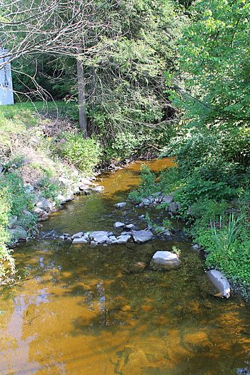
Toby Creek looking upstream
|
|
| Physical characteristics | |
| Main source | Dallas Township, Luzerne County, Pennsylvania between 1,220 and 1,240 feet (370 and 380 m) |
| River mouth | Susquehanna River in Edwardsville, Luzerne County, Pennsylvania and Larksville, Luzerne County, Pennsylvania 518 ft (158 m) 41°15′05″N 75°54′42″W / 41.2514°N 75.9118°W |
| Basin features | |
| Progression | Susquehanna River → Chesapeake Bay |
| Basin size | 36.5 sq mi (95 km2) |
| Tributaries |
|
Toby Creek (also called Toby's Creek) is a stream in Luzerne County, Pennsylvania, in the United States. It flows into the Susquehanna River. The creek is about 10.5 miles (16.9 km) long. It passes through several towns like Dallas, Kingston, Luzerne, and Edwardsville.
The area of land that drains into Toby Creek, called its watershed, is about 36.5 square miles (95 km2). This whole area is a great place for fish to live and migrate. Parts of the creek are good for coldwater fish, warmwater fish, or even for stocking trout. Toby Creek has two main streams that flow into it: Huntsville Creek and Trout Brook.
While some parts of the creek show "degraded conditions," it is not heavily polluted. It is not considered to be a seriously damaged waterway. In the town of Pringle, the creek flows through an underground pipe, but it comes back to the surface in Edwardsville.
The watershed of Toby Creek covers parts of ten boroughs and four townships. Most of this area is rural, meaning it has more natural land than cities. Major roads like Pennsylvania Route 309 and US Route 11 pass through the watershed. The huge Huntsville Reservoir, which holds two billion gallons of water, is also in the creek's drainage area. Many mills were built along the creek in the 1800s, and lots of bridges cross it today. Toby Creek caused big floods in 1942 and 1972.
Contents
Where Toby Creek Flows
Toby Creek starts in Dallas Township. It flows south, then southeast, and then east alongside Pennsylvania Route 415 through Dallas. After crossing Pennsylvania Route 309, it turns east and meets its tributary, Trout Brook, coming from the left.
The creek then flows south and slightly east, staying near Pennsylvania Route 309 and entering Kingston Township. It then turns south-southeast, crosses Pennsylvania Route 309 again, and receives another tributary, Huntsville Creek, from the right. Here, the creek enters a narrow valley called a water gap, flowing very close to Pennsylvania Route 309.
After a short distance, it gradually turns northeast, then south-southeast, briefly going through Courtdale and into Luzerne. In Pringle, the creek goes underground. It reappears in Edwardsville and flows west, then south, until it joins the Susquehanna River. This meeting point is on the border between Edwardsville and Larksville.
Toby Creek joins the Susquehanna River about 187.79 miles (302.22 km) upstream from where the Susquehanna meets the ocean.
Tributaries of Toby Creek
Toby Creek has two named streams that flow into it:
- Huntsville Creek: This creek joins Toby Creek about 5.04 miles (8.11 km) upstream from its mouth. Its watershed covers about 14.7 square miles (38 km2).
- Trout Brook: This brook joins Toby Creek about 7.60 miles (12.23 km) upstream from its mouth. Its watershed covers about 4.20 square miles (10.9 km2).
Water Quality and Flow
In the early 1900s, the lower parts of Toby Creek were polluted by waste from coal mining. However, today, no part of Toby Creek's watershed is considered seriously damaged. It has been described as having "some degraded conditions," but it is not among the most polluted streams in the Middle Susquehanna area.
The creek does have higher levels of nutrients and sodium. There is also one combined sewer overflow near the mouth of the creek, which can release untreated wastewater during heavy rains.
The amount of water flowing in Toby Creek is lowest in August and September. It is highest in April and March. During big floods, the water flow can be very high. For example, in April 1993, the average flow was 269.3 cubic feet per second (7.63 m3/s). During severe floods, the flow can even go over 3,000 cubic feet per second (85 m3/s). The average flow of the creek between 1941 and 1993 was 41.2 cubic feet per second (1.17 m3/s).
The water in Toby Creek is usually slightly alkaline, with an average pH of 7.1. The water also has some hardness, meaning it contains minerals like calcium and magnesium.
The amount of dissolved oxygen in Toby Creek's water is usually good for fish, often over 10 milligrams per liter (0.0100 oz/cu ft). The water also contains small amounts of other substances like carbon dioxide, ammonia, nitrite, nitrate, and phosphorus. The average amount of total dissolved solids in the creek is 117 milligrams per liter (0.117 oz/cu ft).
Land, Rocks, and Weather
The land around Toby Creek changes from its source to its mouth. Near where it joins the Susquehanna River, the elevation is 518 feet (158 m) above sea level. At its source, it is much higher, between 1,220 and 1,240 feet (370 and 380 m) above sea level. This means the creek flows downhill.
Toby Creek flows through a gorge between Trucksville and Luzerne. Downstream from Luzerne, it flows through wider, flatter lands. The area around the creek is generally "rough and hilly." The land has also been shaped by glaciation, which means ancient glaciers moved across it.
The creek's path is winding. The rocks around Toby Creek are made of sandstone and shale. There are also coal deposits in the lower parts of the creek.
A large basin helps to move water away from Kingston and Pringle. The creek then flows into a large underground pipe for some distance before reappearing in Edwardsville. There are also levees and other structures to help control the water flow, especially during floods. Some parts of the creek have been straightened or moved.
The amount of rain in the upper part of Toby Creek's watershed ranges from 35 to 50.4 inches (89 to 128 cm) per year. The water temperature in the creek varies with the seasons, from around 0.0 to 5.0 °C (32.0 to 41.0 °F) in winter months.
The Creek's Watershed
The watershed of Toby Creek covers an area of 36.5 square miles (95 km2). This area is located in north-central Luzerne County. Most of the watershed (59.7 percent) is covered by forests, and 17.7 percent is urban land.
Toby Creek's watershed includes parts of 14 different towns and townships. These include towns like Dallas, Kingston, Luzerne, and Edwardsville. It is next to other creek watersheds like Harveys Creek and Abrahams Creek. A long stretch of land (about 9 miles (14 km)) along the main part of Toby Creek is very developed with towns and cities. This area goes from Dallas through Shavertown, Luzerne, Kingston, and Edwardsville.
Most of the watershed is rural, with 61.3 percent being forested land. About 19.6 percent is grassland, and 16.4 percent is urban land. A small part (2.1 percent) is wetlands, and 0.6 percent is mining land, found near the mouth of the creek.
The watershed is narrow near the mouth of the creek but becomes much wider in its middle and upper parts. The area is growing, with more jobs expected by 2030. Major roads like Pennsylvania Route 309, Pennsylvania Route 118, and US Route 11 all pass through the watershed.
A lot of water is taken from Toby Creek and its smaller streams every day. Most of this water (84 percent) is used by water companies, and some is used for businesses, industry, mining, and homes. The Huntsville Reservoir, which holds about 1.915 billion gallons of water, is also in the Toby Creek watershed.
Toby Creek is a main cause of flooding in towns like Courtdale, Dallas, Luzerne, Pringle, and Kingston Township. However, in Courtdale, the floods usually cause little damage because there aren't many buildings in the flood-prone areas.
There are many swamps, lakes, and ponds in the Toby Creek watershed.
History of Toby Creek
Toby Creek was officially added to the Geographic Names Information System on August 2, 1979.
An old fort used to stand on a flat area near Toby Creek in Kingston Township. This fort was oval-shaped and measured about 337 by 272 feet (103 by 83 m). It was close to the creek and about 0.5 miles (0.80 km) from the Susquehanna River.
In the early 1800s, there were no roads in the Toby Creek valley, but one was built later. People like Peter Grubb operated gristmills (for grinding grain) and sawmills (for cutting wood) on Toby Creek. These were the only ones in Kingston until 1893. Other mills, including a paper mill and a small charcoal furnace, were also built along the creek. In the late 1800s, some of these mills were taken down because they were no longer needed.
In the early 1900s, the main jobs in the watershed were farming and coal mining. The creek's water power was also used for several mills. Railroads like the Lehigh Valley Railroad and the Delaware, Lackawanna, and Western Railroad crossed the watershed and followed the creek's path.
The two biggest floods in Toby Creek's history happened on December 30, 1942, and June 22, 1972. During these floods, the water flow was extremely high.
Many bridges have been built over Toby Creek over the years. Some were built in the 1920s, 1930s, 1940s, and later, with many being repaired over time.
After 2005, a project was done to make the streambanks of Toby Creek more stable.
Wildlife and Nature
The area of Toby Creek upstream from Huntsville Creek is known as a Coldwater Fishery and a Migratory Fishery. This means it's good for fish that like cold water and for fish that travel to different places.
From below Huntsville Creek down to Pringle (where the creek goes underground), Toby Creek is a Trout Stocking Fishery and a Migratory Fishery. This means trout are put into the creek here, and fish can migrate. From Pringle down to the creek's mouth, it's a Warmwater Fishery, suitable for fish that prefer warmer water. Wild trout naturally live and reproduce in the creek from its very beginning all the way to its mouth.
A study by the Susquehanna River Basin Commission found that a section of Toby Creek had some habitat problems. These issues included too much sediment on the bottom, not enough rocky areas (riffles), and poor streambanks. The town of Dallas plans to build a greenway (a natural path or corridor) along the creek.
 | Bayard Rustin |
 | Jeannette Carter |
 | Jeremiah A. Brown |


