
Trabancos (river) facts for kids
The Trabancos is a river in Spain. It flows between the Zapardiel and Guareña rivers and is a branch of the Duero River. The Trabancos starts in Moraña, a region in the north of the province of Ávila, near Blascomillán.
The river starts at about 1,100 meters (3,600 ft) high. It is about 85 kilometers (53 mi) long. Even though its riverbed is usually dry, it only has water flowing constantly during and right after heavy rains.
|
||||
|---|---|---|---|---|
   . |
||||
| Country | Spain | |||
| Length | 85.86 kilometres (53.35 mi) | |||
| Elevation at source | 1,120 metres (3,670 ft) | |||
| Provinces | Ávila and Valladolid | |||
| River mouth | Duero River near the Village of Pollos (Valladolid province) |
|||
| Elevation at mouth | 657 metres (2,156 ft) | |||
| River - Hydrology | ||||
Contents
How the Trabancos River Shaped the Land
From where it starts in Ávila province to where it joins the Duero River near Pollos village, the Trabancos River's path is greatly affected by a geologic fault. This fault formed a very long time ago, likely before the Pliocene era. Like most faults from that time, it runs from the north-northeast to the south-southwest.
This fault separates different types of rock. On the right side, there are materials from the Oligocene epoch. On the left side, there are materials from the Miocene epoch. The very top layer of the ground is made of materials from the Quaternary period.

Scientists have studied the areas around the Trabancos River, especially between the villages of Castrejón and Pollos. They found a series of river terraces on the left side of the river. These are like flat steps or benches formed by the river over time.
- TT-1 platform: This is the oldest terrace, about 35-40 meters (115-131 ft) above the river's flat area (floodplain).
- TT-2 platform: This terrace is about 25-30 meters (82-98 ft) above the floodplain.
- TT-3 platform: This one is about 15 meters (49 ft) above the floodplain.
- TT-4 platform: This is the newest terrace, about 10 meters (33 ft) above the floodplain.
On the right side of the river, there is a "gravel plateau." A scientist named Alfredo Pérez-Gonzalez called this the "Superficie de Alaejos" (The Plateau of Alaejos), named after a nearby village. This plateau has different materials, including red clay soil and a mix of gravel with rounded quartz and quartzite stones.
The river terraces of the Trabancos River are only found on the left side of the valley. This is because the right side has a very steep slope that has been heavily worn away by erosion. This makes it impossible for terraces to form and stay there.
The TT-3 platform has a very strong and thick rock called a conglomerate from the Miocene epoch. It is made of smooth, rounded quartzite pebbles, likely shaped by the Trabancos River long ago. These pebbles are held together by chalk and sandstone.
The fact that the Trabancos River terraces cut across some of the Duero River terraces tells us that the Duero River terraces that are cut are older than the Trabancos terraces. This helps scientists understand the history of the landscape.
History of the Trabancos River Area
Even though the eastern part of the Trabancos River isn't very important for water flow today, it played a big role in the history of the North Spanish Plateau until the 13th century.
Ancient Times in the Trabancos Valley
Scientists have found signs of people living in the Trabancos area during prehistoric times. These findings are on hillsides near Narros del Castillo (in Ávila) and Siete Iglesias de Trabancos (in Valladolid). The items found date back to the Lower Paleolithic era, which is a very old part of the Stone Age.
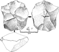
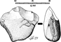
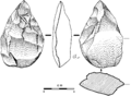
At these sites, people have found stone tools on the surface of the ground. These tools were made during the Acheulean period. They include different types of stone cores (where flakes were removed), stone flakes, chopping tools, and handaxes.
- Stone tools from the Acheulean culture found near the Trabancos River
-
Centripetal lithic core
-
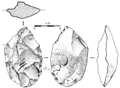
Lithic flakeHandaxe
-
Chopper
-
Another lithic flake handaxe


Not many clear signs of people from the late Roman period have been found. Some people think this is because the land and weather in the Trabancos valley were very harsh. It's possible that before the Romans, this area was a "no-man's-land" between two Hispanic tribes, the Vaccei and the Vettoni.
Some broken pieces of pottery from Spain's Iron Age have been found in Siete Iglesias de Trabancos. These pieces have comb-like decorations. Other prehistoric finds directly along the Trabancos River are rare. However, in nearby areas like Alaejos, archaeologists have found several human burial sites from the Bronze Age. Near the mouth of the Trabancos River, in Pollos village, relics from the Duero River area have been found. These include pottery from the Spanish Bronze Age, some with carved decorations.
.jpg)
.jpg)
The Romans Arrive
The Romans probably came to the Trabancos region in the 2nd century BC. However, this area was not a main focus for them. Most important travel routes were to the east (along the Eresma River) and to the west (the "Vía de la Plata" or "silver road").
Even so, we know there were several villages in the Valladolid area that might have existed before the Romans. In fact, the name 'Trabancos' itself might come from a time before the Romans arrived.
At a site called Lavachicha (in Castrejón), pieces of Roman pottery called terra sigillata hispanica have been found. In the 1980s, an excavation there uncovered a burial ground from late Roman or possibly Visigothic times. Similar Roman pottery has been found in Carpio, but only on the surface. In Nava del Rey, another town along the Trabancos, more surface finds of Roman pottery were made, including a striking red plate fragment. These plates were often carried by Roman soldiers on their military campaigns.
The Middle Ages and Forts
During the Middle Ages, the Trabancos area was not considered very important. There are no written records about the region before the 12th century. We know that between 711 and 740 AD, Berbers had troops in the Duero valley. However, most of them left because of a severe drought around 750-753 AD. Only the most important towns survived.
During the Christian reconquest, not much effort was put into settling this region. The kings at the time focused on more important areas to the south. This is why Medina del Campo remained untouched until the 12th century.
However, a professor named Tomas Mañanes found many defensive towers, or "Torrejones," in the Trabancos valley. These towers were built in the 11th century, even before official resettlement. More than ten of these defensive structures were found along the Trabancos River in Valladolid province.

What Were the Torrejones For?
Most of these towers are in areas that are empty today. Only the ones in Castrejón and Alaejos later became castles. The torrejones were simple, square or egg-shaped buildings with several floors, made of limestone or brick.
There were two main types:
- Some had small peepholes and were built in isolated areas.
- Others were small castles located in what used to be farming villages (now deserted).
Because these structures looked similar and were close enough for people to see each other, some historians believe they were on opposite sides of the border between the Kingdoms of León and Castile. These forts were made stronger in the 12th and 13th centuries because of fights between the two kingdoms. It seems there were more forts on the Castilian side (near the Trabancos) than on the Leonese side (near the Guareña River). This might mean that the local soldiers from Medina del Campo had to defend themselves, while the Leonese side could rely on help from royal troops.
The Trabancos River Area Becomes Important
Even though it had forts since the tenth century, the Trabancos area didn't become truly important until the 13th century. King Alphonse VII (1126–1157) made some changes that gave Leonese lands to the Crown of Castile. This included the rich Tierra de Campos to the north of the Duero, and the alfoz de Medina del Campo to the south. The Medina del Campo area was poor but important for defending the Duero valley passes.
After Alphonse VII died, his lands were divided among his sons, leading to constant conflicts over these areas. The wars became very intense between 1178 and 1181. A fierce battle even took place on the banks of the Trabancos River in 1179, leading to a peace treaty between Alphonse VIII of Castille and Ferdinand II of León. However, peace didn't last long.
Fighting continued after Ferdinand II died. The border became heavily militarized, with new castles built and more troops sent to the Trabancos River area. This ironically made the region more valuable. For the first time, documents mentioning the area started appearing in the records of cathedrals in Zamora, Salamanca, and Segovia. These documents mentioned places like Siete Iglesias de Trabancos (in 1178) and Alaejos (in 1167).
In 1265, a document recorded a new conflict: a battle between the dioceses of Salamanca and Segovia over control of the churches east of the Trabancos. Salamanca had used the border conflicts to take control of towns like Medina del Campo, even though it was under Castilian rule and Salamanca belonged to León.
The Trabancos River Area Today
Today, when the Trabancos River is dry, it might seem strange that it was once so important. However, the area's historical treasures are slowly disappearing.
Special Protection Area (ZEPA)
.jpg)
The middle and end parts of the Trabancos River are part of a Special Protection Area (SPA), also known as ZEPA in Spanish. This area is called Tierra de Campiñas (Land of Plains).
ZEPA SPAs are special natural areas chosen by European Union countries. They are important for protecting bird species that are at risk of disappearing. This is done following rules set by the EU's "Birds Directive."
This protected area also includes parts of the Guareña River to the west and the Zapardiel River to the east. The Trabancos River ZEPA SPA is the largest in the Autonomous Community of Castile and León. It covers almost 1,400 square kilometers (540 sq mi). This includes areas in Salamanca, Ávila, and a large part of Medina del Campo. About 73% of this ZEPA SPA is in the province of Valladolid.
Most of this protected region (97%) is farmland, mainly for growing cereal crops and other irrigated plants. The areas that are important for nature make up the remaining 3%. This region has tilled land, pastures, small pine and holm oak woods, and empty areas with salty bushes. There are also many small ponds that only have water during the winter. These ponds and parts of the Trabancos River banks are in a fragile state. However, they still support the plants and animals that live in riverside environments.
The Trabancos region is very important for its large number of great bustards (over 2,000 birds). It also has the biggest group of black-bellied sandgrouses (Pterocles orientalis) that reproduce in Castile and León (with over 200 pairs). In winter, more than 1,500 red kites (Milvus milvus) come to nest here.
There are also many birds of prey, like Montagu's harriers (50 pairs) and lesser kestrels (almost 150 pairs). Other birds of prey include hawks, goshawks, falcons, and owls. The region is also home to many gamebirds, such as the red-legged partridge (Alectoris rufa).
Even though they are important, the number of little bustards (Tetrax tetrax) in the region seems to be decreasing. This protected area is a stop for many migrating birds and a winter home for waterfowl like cranes and geese. Some even use the temporary ponds for nesting during wet winters.
_in_Spain_fields.jpg)
|
.jpg)
|

|
See also
 In Spanish: Río Trabancos para niños
