Tropical Storm Beryl (2006) facts for kids
| Tropical storm (SSHWS/NWS) | |

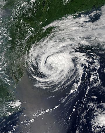
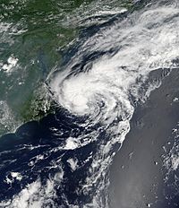
Tropical Storm Beryl near peak intensity.
|
|
| Formed | July 18, 2006 |
|---|---|
| Dissipated | July 21, 2006 |
| Highest winds | 1-minute sustained: 60 mph (95 km/h) |
| Lowest pressure | 1000 mbar (hPa); 29.53 inHg |
| Damage | Minimal |
| Areas affected | Long Island, Massachusetts, Atlantic Canada |
| Part of the 2006 Atlantic hurricane season | |
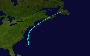
Tropical Storm Beryl was the third tropical storm of the 2006 Atlantic hurricane season. A tropical storm is a strong storm with rotating winds. It formed on July 18, 2006, from a weather disturbance. The storm moved north and got stronger. Its winds reached about 60 mph (95 km/h).
Beryl then turned northeast and became weaker over cooler water. On July 21, it hit the island of Nantucket, Massachusetts. Soon after, it changed into an extratropical cyclone. This means it became a different type of storm, more like a regular weather system. The storm's leftover parts moved through Nova Scotia in Canada. On July 22, they joined with a cold front.
Beryl caused big waves along the coast of the United States. In Massachusetts, it brought light rain and strong winds. No damage was reported there. Later, Beryl caused moderate rain and gusty winds in Atlantic Canada. This led to some small power outages but little damage. No one was reported to have died because of the storm.
Contents
How Tropical Storm Beryl Formed and Moved
A cold front moved away from the East Coast of the United States on July 16. It then stopped near the coast of North Carolina. This front slowly broke down into a low pressure system. This system created two smaller disturbances. One was near Cape Cod, and the other was south of Cape Hatteras, North Carolina.
The first disturbance quickly became an unnamed tropical storm. The second one stayed wide and messy. But by July 18, the second system became much more organized. It developed into Tropical Depression Two. This happened when it was about 220 miles (355 km) south-southeast of Cape Hatteras. A tropical depression is the first stage of a tropical storm.

The depression moved slowly to the north-northwest. It was in an area with light wind shear. Wind shear is when winds blow at different speeds or directions at different heights. This can affect how a storm forms. The storm also had good upper-level outflow, which helps storms grow. Soon, it became Tropical Storm Beryl.
At first, Beryl's center was exposed, meaning it didn't have much rain or thunderstorms around it. But the next morning, strong thunderstorms grew again. The storm kept getting better organized. With warm ocean water, Beryl slowly got stronger. Its winds reached 60 mph (95 km/h) on July 20. At this time, it was about 120 miles (190 km) east of Nags Head, North Carolina.
Beryl stayed at its strongest for about 18 hours. It moved along the coasts of the Mid-Atlantic and New Jersey. During this time, a calm, clear area like an eye formed in the middle of its thunderstorms. Later on July 20, Beryl started to get weaker. This happened as it moved over cooler ocean water.
Winds from a weather system ahead of Beryl made it speed up to the northeast. Early on July 21, the center of the storm crossed the island of Nantucket. Its thunderstorms faded as it moved into even colder waters. Shortly after noon on July 21, Beryl became an extratropical cyclone. This happened just east of Cape Cod. Hours later, it made landfall in southwestern Nova Scotia, Canada. On July 22, the leftover parts of Beryl joined with a cold front over Newfoundland.
Getting Ready for the Storm
Weather experts first thought Beryl might hit the Carolinas. So, a tropical storm watch was put in place for the eastern coast of North Carolina. This watch meant that tropical storm conditions were possible.
When it became clear Beryl would move northeast, a tropical storm watch was issued for parts of Massachusetts. This included Cape Cod, Nantucket, and Martha's Vineyard. This happened about 33 hours before the storm arrived. About 22 hours before landfall, the National Hurricane Center changed the watch to a tropical storm warning. A warning means tropical storm conditions are expected. They also issued a watch for eastern Long Island in New York.
The Massachusetts Emergency Management Agency got ready for the storm. It was like a practice run for the hurricane season. Local Red Cross groups opened their doors. Two volunteer teams were ready to help if needed. Police departments in southeastern Massachusetts had extra staff on duty. Many fishermen made their boats safe. Some business owners put boards on their windows to protect them.
Days before Beryl reached Atlantic Canada, the Canadian Hurricane Centre issued gale warnings. These were for the coastal waters off Nova Scotia and Newfoundland. They also warned about heavy rainfall for western Nova Scotia, including Halifax.
How Tropical Storm Beryl Affected Areas

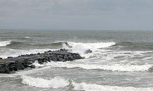
Tropical Storm Beryl caused high waves along the East Coast of the United States. Waves in the open ocean reached about 19 feet (5.97 m). Near the southern coast of Nantucket, waves were 10 feet high as the storm got closer. Four people had to be rescued by lifeguards from dangerous rip currents. High waves were also seen along the southern coasts of Massachusetts and Rhode Island.
Beryl also caused a storm surge of 0.9 feet on Nantucket. A storm surge is a rise in sea level caused by the storm's winds pushing water ashore. Winds across southeastern Massachusetts were not very strong. The strongest wind gusts were about 44 mph. Some unofficial reports said gusts reached 51 mph.
Beryl dropped moderate precipitation (rain) just offshore. The most rain in the United States was 0.97 inches (24.6 mm) on Nantucket. In Chatham, about 0.33 inches of rain fell. The only damage reported was some fallen telephone poles and tree branches. Overall, the impact was small. There were no power outages, deaths, injuries, or emergencies at sea because of the storm.
The leftover parts of Beryl brought moderate rain to Atlantic Canada. The most rain officially recorded was 2.8 inches (71 mm) in Scotts Bay, Nova Scotia. Unofficially, some places got 3.5 inches (88 mm). In some areas, 1 inch of rain fell in just one hour. This rain caused some flooding, with streams overflowing and flooding some streets. Moderate winds were reported, reaching 60 mph (96 km/h) in southern Nova Scotia. These winds knocked down some tree limbs and caused some power outages. The damage was minor.
Related pages
- NHC's archive on Tropical Storm Beryl
|
Tropical cyclones of the 2006 Atlantic hurricane season |
||||||||||||||||||||||||||
|
|
|||||||||||||||||||||||||
|
|
||||||||||||||||||||||||||
See also
 In Spanish: Tormenta tropical Beryl (2006) para niños


